

The original “Beltway Bandits” had nothing to do with defense contractors. Before Booz Allen Hamilton ever submitted a consulting proposal, a Fairfax County career criminal named Joseph Francis Fearon was using I-495 as his getaway road, robbing suburban homes across the region and disappearing into traffic before police could catch him.
That’s where the name actually came from. The defense industry meaning came almost a decade later.
But let’s start with the road itself.
The Fort Circle That Never Was
The first serious proposal for a ring road around Washington shows up not in a highway plan but in a parks story. On March 30th, 1930, the Baltimore Sun described the city’s grand ambition to connect the old Civil War forts:
One of the most ambitious plans for park improvement within the District is the proposed acquisition of all of the twenty-four remaining Civil War forts which circle the city … Fourteen of the twenty-four already have been bought and when funds are available to purchase the rest a parked drive will be constructed joining them all. This park drive would extend in a circle around the city, but well within the District line, and in addition to providing a pleasure route for motorists, would be a highly practical circumferential highway counted upon to facilitate the movement of traffic along the rim of the district.
Those forts had been ringing Washington since the 1860s, built to protect the capital from Confederate attack. By 1919, the Commissioners of the District were already pushing Congress to acquire what remained and link them with a “Fort Circle” system of parks. Congress passed a version of the bill in 1925 and land acquisition began.
Then the Depression hit. Then World War II. Then the suburbs happened faster than anyone expected.
A Road for a Growing Region
By 1951, the math had changed completely. The postwar suburban explosion had pushed development so far out from the city that the old fort circle route was useless as a traffic solution. Washington needed something bigger.
In March 1951, the Senate Public Works Committee asked the Public Roads Bureau to draft a map for a high-speed loop around the capital. The goal was a limited-access circumferential highway for the growing army of federal workers commuting in from Maryland and Virginia.
Senator Spessard L. Holland of Florida became the loudest advocate. He argued the road would solve space shortages in the District, clear out the temporary World War II buildings still cluttering the Mall, reduce Washington’s attractiveness as a nuclear target by dispersing federal agencies, and ease the region’s traffic. He wanted the route set “an arc about 11 air miles from the White House zero mark.” That foresight about dispersal and nuclear targeting is a little unsettling in retrospect.
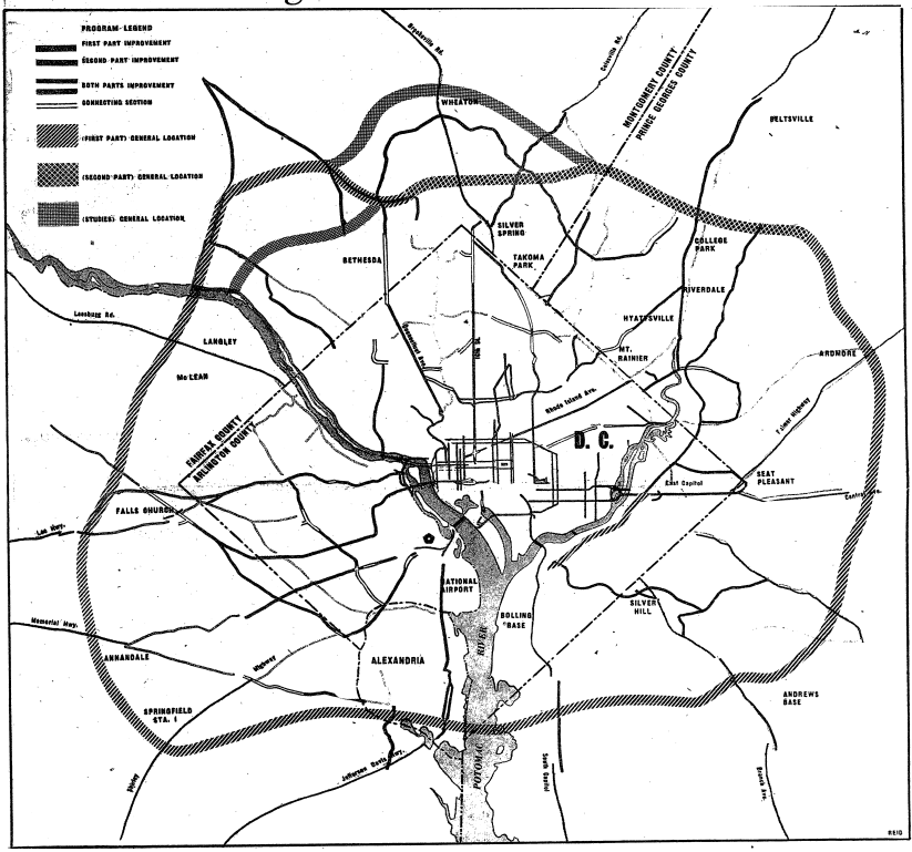
In December 1952, the Washington Post published the Regional Highway Planning Committee’s full proposal: a four-lane ring road around the nation’s capital, plus major upgrades to the primary roads feeding into the District. Total price tag: $328 million.
That same package included a $26,200,000 upgrade to Rock Creek Parkway. Worth every penny.
The Fight Over Rock Creek Park
Approving the road was one thing. Building it through Montgomery County was a different problem entirely.
Maryland’s plan was to route the highway through as little developed land as possible to keep costs manageable. In Prince George’s County, that worked fine. In Montgomery County, it ran directly into Bethesda’s affluent subdivisions and large homes. Carving a highway through expensive property was neither financially nor politically viable.
That left one option: cut through three miles of federally owned Rock Creek Park.
The backlash was immediate. A letter to the Washington Post editor in May 1955 captured the mood:
Your paper tells us of the determination of the Maryland State Roads Commission to wade into Rock Creek Park with its highway program in spite of protests. So, score another point in favor of arrogant defiance by public officials in the war against law, orderly procedure and the public interest. The Maryland State Roads authorities defied not only the thousands of friends of Rock Creek Park but the congress, the Department of the Interior, the Courts of the District and Maryland, and the law itself. “Here we go,” they seemed to say, “try and stop us.”
Twenty-one residents of Parkwood Drive in Bethesda unified behind a petition to halt development in the park. Mr. and Mrs. Robert Brownell filed suit in April 1955 to stop it. They lost.
The alternative route, a mile further north, would have been better traffic engineering. It was also politically impossible given the neighborhoods it would have cut through. Rock Creek Park was the path of least resistance.

On September 28th, 1955, the federal government gave final approval for what it was calling the “Belt Highway.” Segments had been opening since 1957. If you want more on DC’s other highway battles from this era, the 1968 war over DC’s interstate highway system nearly tore the city apart, and the Three Sisters Bridge, a Potomac crossing that was supposed to feed that system, was never built at all.
Completion and the Name Fight
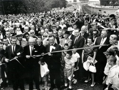
On August 17th, 1964, the final link in Maryland connected and the full 64-mile loop was complete. Governor J. Millard Tawes cut the ribbon near the New Hampshire Avenue interchange and called it “a road of opportunity.” Administrator Rex Whitton called it “a huge wedding ring for the metropolitan area.” Representative Carlton R. Sickles of Maryland made the day’s briefest speech: “I’m so happy, I can’t express myself.” Virginia’s last segment had dedicated on April 2nd of the same year. (FHWA has the full opening day record.)
Nine years of construction. Thousands of displaced families. One complete ring around the nation’s capital.
Now what to call it?
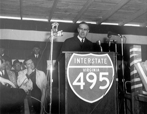
Maryland had settled on “Capitol Beltway.” Virginia proposed “Capital Ring,” with some officials pushing for a name honoring George Washington or George Mason. In the interest of uniformity, Virginia eventually accepted “Capitol Beltway.” Then someone raised a distinction: “Capitol” referred specifically to the building housing Congress, while “capital” referred to the city itself. Using “Capital” would be more accurate.
On June 22nd, 1960, both Maryland and Virginia officially adopted “Capital Beltway.” That was the name that stuck.
“Colonial Beltway” was also on the table at one point. Not a huge loss. Imagine being stuck in traffic on the Capital Ring. The soul-crushing quality would be identical.
“Inside the Beltway”
The phrase “inside the Beltway” first appeared in print in a 1977 Washington Post headline about trout fishing: “Inside-the-Beltway Trout Fishing Nears.” A sentence that requires some imagination today.
The political meaning moved in fast. By the late 1970s and through the Reagan years, the phrase became shorthand for the insular culture of Washington’s permanent class: the lobbyists, staffers, consultants, and journalists who orbited the federal government and increasingly spoke a language that meant nothing to people in the rest of the country.
By the 1994 midterms, it was a reliable political attack. “Inside the Beltway” meant out of touch, disconnected, captured by Washington consensus. The Washington Post ran a piece that year examining whether the phrase had already become a cliche.
It had. It hasn’t stopped being used.
The Real Beltway Bandits
While all that political culture was developing, Joseph Francis Fearon of Fairfax was busy earning the name the hard way.
In the late 1960s, Fearon led a crew that police dubbed the “Beltway Bandits.” The method was straightforward: use the new Capital Beltway to travel from suburb to suburb across the region, burglarize homes along the route, and escape back onto the highway before police could respond. By the time authorities caught up with the gang, they had stolen an estimated $500,000 worth of goods.
In May 1968, Fearon was convicted in Fairfax County on several burglary charges and sentenced to five years in the Virginia State Penitentiary. That alone would make a career. Fearon wasn’t done. He picked up a separate conviction in Arlington for threatening to dynamite the home of a county detective in 1967. His lawyer argued he was joking. The court gave him a $100 fine and 90 days in the county jail.
He was also shot by FBI agents while fleeing through Hillcrest Heights in Prince George’s County. Fearon had been staying at the Prince George’s Motor Hotel at 3714 Branch Avenue (today a CVS, as these things always go) when an unidentified woman spotted two undercover agents in the lobby and tipped him off. He bolted across Branch Avenue toward Iverson Mall and took a round while running.
In 1981, facing new charges for robbing a local resident at gunpoint, Fearon received a 38-year sentence. Here’s how the Washington Post described his record at that point:
Fearon gained notoriety in the late 1960s after police identified him as the alleged ringleader of a gang that authorities dubbed the “Beltway Bandits.” The group was said to have stolen $500,000 worth of goods and used the Capital Beltway to escape while traveling from suburb to suburb to burglarize homes. Charged and convicted in Fairfax County in May 1968 for several burglaries, Fearon was ultimately sentenced to five years in the Virginia State Penitentiary. He was later convicted of several other charges including one in Arlington in which he was found guilty of threatening to dynamite the home of a county detective in 1967.
38 years. For a man who had already been convicted, already been shot, already served time in state prison. At some point you run out of highway.
Then the Meaning Changed
The defense contractor meaning of “Beltway Bandit” first appeared in print in a January 25th, 1978, Washington Post article. The tone at the time was joking, almost admiring. These were the consulting firms that had clustered along I-495 near the Pentagon, the CIA, and the NSA, landing contracts for weapons systems, electronic warfare, and policy analysis.
The numbers grew fast. By 1979, the federal government was awarding 13,848 contracts for outside expertise, totaling more than $9.3 billion. Over 1,000 advising firms were operating in the Washington area by 1980.
The Reagan administration’s military buildup poured fuel on all of it. Defense-related service contracts exploded as agencies managed annual budgets exceeding $300 billion by mid-decade. The firms in the Northern Virginia and Maryland office parks grew enormous on Pentagon money. The early joking tone of “Beltway Bandit” sharpened into something more pointed as critics documented the revolving door between government agencies and contractors: senior officials leaving to join the firms they’d previously overseen, building in structural conflicts of interest that nobody seemed particularly motivated to resolve.
Booz Allen Hamilton. SAIC. Leidos. Mitre. The Pentagon itself had its own strange origin story, for that matter.
The names changed. The traffic didn’t.
The Beltway didn’t just enable office parks; it also opened up huge tracts for residential development. A 1961 Washington Post map shows the city’s suburbs starting to spill across both rivers, and a few years later Robert E. Simon broke ground on Reston as a planned community out Route 7.
Back at the end of the last century, my friend and former boss Douglas B. Feaver wrote this article about the Beltway’s early evolution:
http://www.washingtonpost.com/wp-srv/local/2000/beltway083099.htm
I remember when the part of The Beltway was “finished” but not opened at University Blvd. It was only 2 lanes. Virginia opened sooner, and everyone realized how inadequate 2 lanes were. So (can’t remember) if one or 2 lanes were added – before that stretch was opened. Spent some time watching them move a number of houses from that location to new lots. One is still at the NW corner of Burnt Mills Ave & Rt 29.
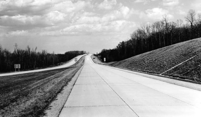
Doug, the segment of the Beltway between Md. 97 (Georgia Avenue) and Md. 193 (University Boulevard) opened about two years before the full 64 miles was completed in 1964. It was four lanes wide then, but was widened to 6 lanes by the time the rest of the Maryland Beltway was completed in 1964.
Other segments of the Beltway were also built and opened ahead of the rest of the highway, including the Cabin John Bridge (now called the American Legion Bridge) and the Wilson Bridge, and the section of the Beltway between the present-day Pooks Hill Interchange (I-270 and Md. 355 today) and Connecticut Avenue (Md. 193 then, Md. 185 now).
Most of the Capital Beltway in Northern Virginia (in particular between Springfield and the American Legion Bridge) was only four lanes wide through the mid-1970’s, when it was widened from 4 lanes to 8 lanes in one massive project.
I have it on reliable authority that the late federal highway engineer W. Lee Mertz told the Virginia Department of Highways (VDH) that a four lane Beltway would be adequate, which is why it was narrower than the rest of the road.
On a somewhat related note, I was once told that Mike Causey (the guy who does the federal reports on WTOP) was the one who coined the phrase “Inside the Beltway.”
I remember roller skating on the yet unfinished beltway as a young teenager. We climbed down the embankment for the overpass on Fernwood Road in Bethesda and had a glorious time.
I was a young kid but before the Beltway Route 66 was the main thorofare out of DC heading into Va.
This article is not really complete without some before and after ariel shots….don’t you agree?
From Hyattsville, MD we always travelled through the District (including SE) to get anywhere. To this day, I’m familiar with District roads and usually travel “through” rather than “around.”
I wasn’t clear as I should have been – 2 lanes (each direction) originally built and MD added a 3rd lane (inner and outer) before that segment (near MD 193 towards MD 97) of the beltway was opened. Also no one at that time had an inkling that 495 would have any local traffic using it. Most everyone thought it was going to be just a bypass around DC.
Perhaps because the Beltway was to be accompanied by various radial routes, all of which were cancelled in the northern arc from the Potomac River to the B-W Parkway.
While the highway was in final design in the late 1950s, Virginia officials requested that Bureau of Public Roads (BPR) federal highway officials approve a six-lane design on the entire 22-mile Virginia section of the Beltway, but the BPR approved only four lanes on the above 14.5-mile segment, an action that by the late 1960s was seen by many people to have been a mistake due to the frequent peak period traffic congestion that had affected that segment by then, although it can be argued that when the final design had to be frozen in preparation for construction in the late 1950s, that the traffic projections justified no more than four lanes on that segment, given the modest level of residential and business development that existed at that time in Northern Virginia. The entire eastern portion of the Beltway east of I-95 was built with six lanes (three each way), so an ‘I-95 bypass’ section of the Beltway was built with six lanes from the outset.