
GoDC buddy Wayne once emailed and asked the question that everyone asks. Why is there no J Street in DC? Walk north on 16th Street from Lafayette Square and you cross H Street, then I Street, then K. J just isn’t there.
Everybody has a theory. We went looking for the evidence instead: the commissioners’ 1791 letter, the first engraved map of the city, and a century of Washington newspapers. The record tells a better story than any of the theories.
Was it a grudge against John Jay?
Many believe the missing J Street is a snub. The story goes that Pierre L’Enfant, the French-born engineer who planned the city, left out J to insult John Jay, the first Chief Justice of the Supreme Court.

Why would L’Enfant hold such contempt for Jay? The usual answer is the Jay Treaty, signed with Great Britain on November 19, 1794. It got British troops out of their forts in the Northwest and sent other disputes, including the border with Canada, to arbitration. It was hugely unpopular.
Jefferson’s side favored France. Hamilton’s side favored Britain. L’Enfant was a Frenchman, and Jefferson was deeply involved in the new city. Put those together and you get a tidy theory. It’s a nasty, but subtle, way to get back at a political enemy, and one that lasts as long as the city does.
Sorry to burst your bubble. Thomas Jefferson told L’Enfant in a letter dated February 27, 1792 that “your services must be at an end.” That was more than two and a half years before the treaty was signed.
And there’s a bigger problem, because L’Enfant never named the streets at all. We’ll get to that below.
The grudge story doesn’t seem to be very old, either. We searched the Library of Congress’s digitized Washington newspapers and found readers asking about J Street again and again between 1911 and 1951. Not one answer we found blamed John Jay, and by 2000 it was already being debunked.
Is K for kilo?
Here’s a cleverer one. The street that sits where J should be is the grand one. K Street was planned at 147 feet wide, which the Park Service calls “unusually broad.” Its neighbors, I and L, were 90 feet.
So maybe the planners skipped to K on purpose. After all, K is the universal symbol for 1,000.
Well, this too is false. K stands for kilo, the metric prefix from the Greek for thousand, and France adopted the metric system, kilo and all, in 1795. Washington’s lettered streets were decided in 1791.
A theory that makes you sound really intelligent while telling it at bars, but … sorry, false.
Blame it on the alphabet
This is the best bet. As you’ll see, though, nobody in 1791 wrote it down.
In the 1700s, I and J were not quite separate letters. Samuel Johnson’s 1755 Dictionary of the English Language files them together, with I words and J words mixed in one run. Johnson himself wrote that the two “may be more properly accounted two letters.” Which tells you they weren’t always counted that way.
Even in 1828, Noah Webster’s American Dictionary said J “has been added to the English Alphabet in modern days.”
Printers worked the same way. Early printers marked their sheets with a 23-letter alphabet that treated I and J as one letter. And old Roman numerals often ended in a j, as in iij for 3 or viij for 8.
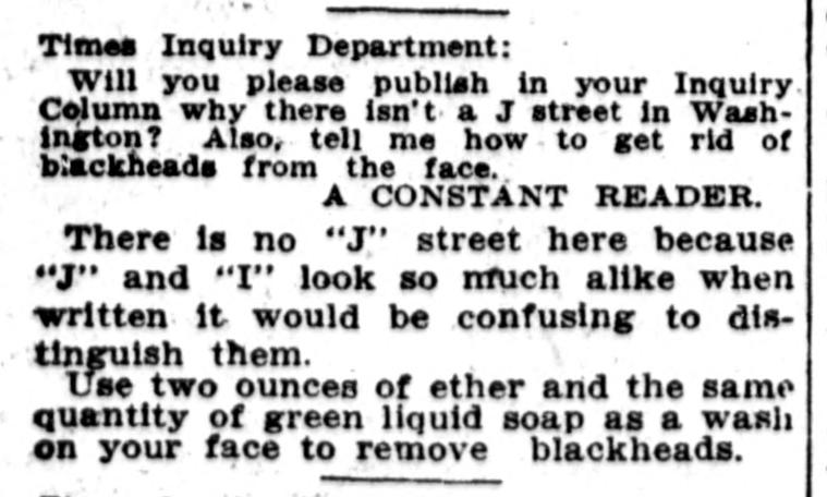
Washington’s newspapers gave this answer for decades. In 1911 the Washington Times told a curious reader there was no J Street “because “J” and “I” look so much alike when written it would be confusing to distinguish them.”
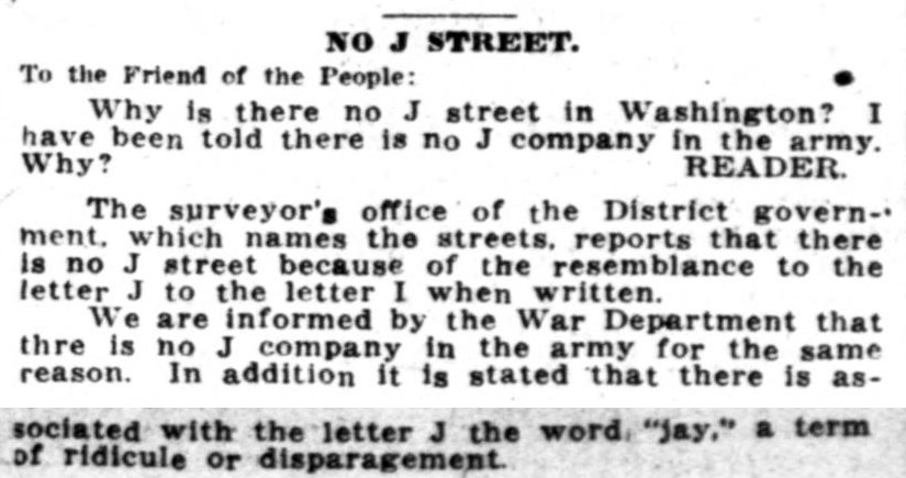
In 1922 the Washington Herald went to the District surveyor’s office, which named the streets. Its answer: J and I looked too much alike when written. The War Department said there was no J company in the Army “for the same reason.” And J, the paper added, carried “the word “jay,” a term of ridicule or disparagement.”
Not everyone bought it. “Really, it wasn’t too good an idea,” Evening Star columnist Charles E. Tracewell wrote in 1951, “for it would have been confused no more than Q street is with O street.”

What the record shows
So who did name the streets, if not L’Enfant? On September 8, 1791, the three commissioners in charge of the new city, Thomas Johnson, David Stuart and Daniel Carroll, settled on the city’s name and its street system. The next day they wrote to L’Enfant from Georgetown:
“We have agreed that the federal District shall be called “The Territory of Columbia,” and the federal City “The City of Washington”: the title of the map will, therefore, be “A Map of the City of Washington in the Territory of Columbia.” We have also agreed the streets be named alphabetically one way, and numerically the other; the former divided into North and South letters, the latter into East and West numbers from the Capitol.”
That’s it: letters one way, numbers the other, and not a word about J. And L’Enfant’s own 1791 manuscript plan at the Library of Congress doesn’t letter its streets at all.
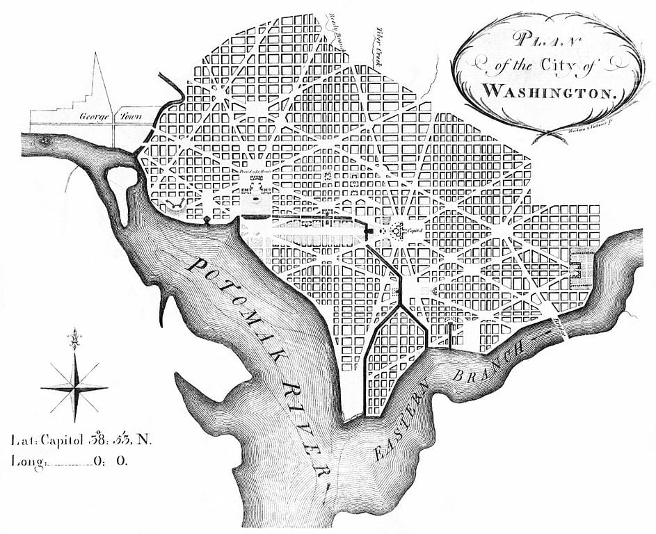
Then L’Enfant was out. Surveyor Andrew Ellicott and his brothers redrew the plan for engraving, and Thackara & Vallance printed it in Philadelphia in 1792. Look at the small letters on the streets north of the President’s House.

There it is, i and then k. This is one of the first engraved maps of the city, and J is already gone, with no note and no explanation.

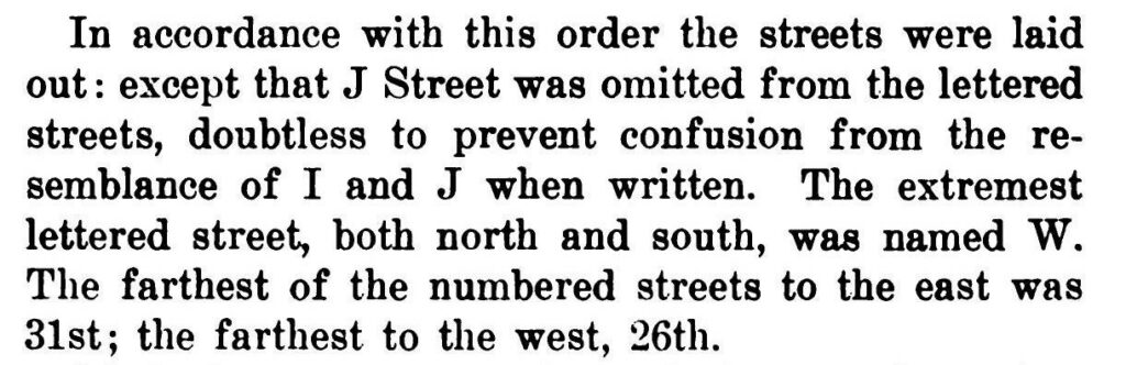
The first written explanation we could find came more than a century later. On May 3, 1897, Justice Alexander B. Hagner read a paper on Washington’s street names to the Columbia Historical Society. J Street, he said, “was omitted from the lettered streets, doubtless to prevent confusion from the resemblance of I and J when written.”
“Doubtless.” A good guess, but a guess. Today the National Park Service’s own history of the L’Enfant Plan still hedges: “Most likely the letter was omitted due to its visual similarity to the letter “I.””
Loose ends
A few wrinkles keep the case open.
J did make it onto a map of Washington once, by mistake. On J.H. Colton’s 1855 map of the city, the streets just west of North Capitol Street run L, J, I, H. There’s no K. The engraver put a J where K Street belongs.

Look at the block between New Jersey Avenue and North Capitol Street, square 621. Read down: L Street, J Street, I Street, H Street.

The same slip turns up on Johnson’s 1862 map of Washington, which reused the same engraving. For a few years, if you went by the map, Washington had a J Street after all.
The letters stop at W for a plainer reason. The northernmost and southernmost lettered streets in the plan both happened to be W Street. The city simply ended there, so there’s no X, Y or Z.
Later, as the city grew past its original boundary, the Highway Plan of 1898 carried the alphabet outward with names: one, two, then three syllables. Those names use J freely, with Jackson Street NE, Jefferson Street NW, and Jenifer, Jocelyn, Juniper and Jonquil streets NW.
But in Columbia Heights and Mount Pleasant, the two-syllable run goes Irving, then Kenyon, so there’s no J there either. We haven’t found anything that explains why.
Washington isn’t alone, since Anchorage skipped J Street too. Sacramento, on the other hand, has a J Street downtown.
And then there’s Jay Street
There is a Jay Street in Northeast, in Ward 7. In 1936 a Washington Times reader insisted it “was named after the Chief Justice of the United States Supreme Court, John Jay,” as “every old resident of the District knows.” We haven’t been able to confirm that. But if he’s right, the man supposedly snubbed by the city got a street after all.
Now head to the city’s eastern edge, where Jay Street runs. Just across Eastern Avenue, in Fairmount Heights, Maryland, there’s a J Street. It’s a real one, single letter and all, a few blocks from Jay Street NE.
Washington never got its J Street. Its neighbor did.
For how the rest of the city’s streets got their names, see our history of DC street names.
We use AI to help research, write and edit stories across our sites. Here’s how we use AI.Suggest a correction