Skip to content
Ghosts of DC

Ghosts of DC

  • The Best Of
  • Neighborhoods
    • Southwest DC
      • Waterfront
    • Maryland
      • Gaithersburg
      • Rockville
      • Bethesda
      • Hyattsville
      • Silver Spring
      • Bladensburg
    • Virginia
      • McLean
      • Falls Church
      • Alexandria
      • Vienna
      • Arlington
    • Southeast DC
      • Congress Heights
      • Navy Yard
      • Capitol Hill
      • Anacostia
    • Northeast DC
      • Trinidad
      • Woodridge
      • Deanwood
      • Brookland
    • Northwest DC
      • Tenleytown
      • Park View
      • Friendship Heights
      • Brightwood
      • Crestwood
      • Sheridan-Kalorama
      • The Palisades
      • Logan Circle
      • Petworth
      • Glover Park
      • Bloomingdale
      • Georgetown
      • Woodley Park
      • Dupont Circle
      • Columbia Heights
      • Cleveland Park
      • Adams Morgan
      • Mt. Pleasant
      • Chevy Chase
      • Cathedral Heights
      • Chinatown
    • Lost Neighborhoods
      • Hell’s Bottom
      • Swampoodle
      • Murder Bay
  • Notable People & Places
    • Places
      • Washington Monument
      • Library of Congress
      • The White House
      • The Capitol Building
      • Dulles Airport
    • People
      • Franklin D. Roosevelt
      • Calvin Coolidge
      • Officer Sprinkle
      • Dwight D. Eisenhower
      • Warren G. Harding
      • William McKinley
      • Abraham Lincoln
      • John F. Kennedy
      • Teddy Roosevelt
      • Woodrow Wilson

GoDCers Love Maps

Cool old historical maps of Washington, D.C.

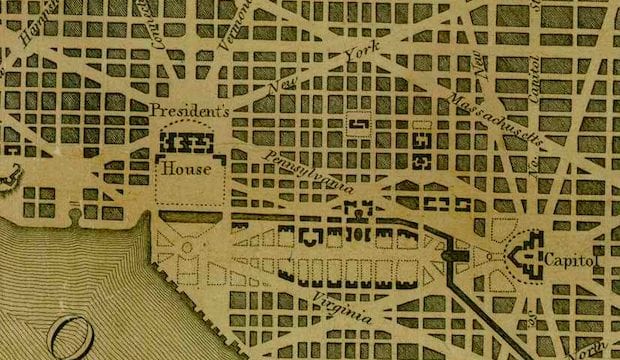
Explore DC in 1903: A Map of the Department of State Location

November 21, 2021May 28, 2014 by ghostsofdc
1903 map of Foggy Bottom

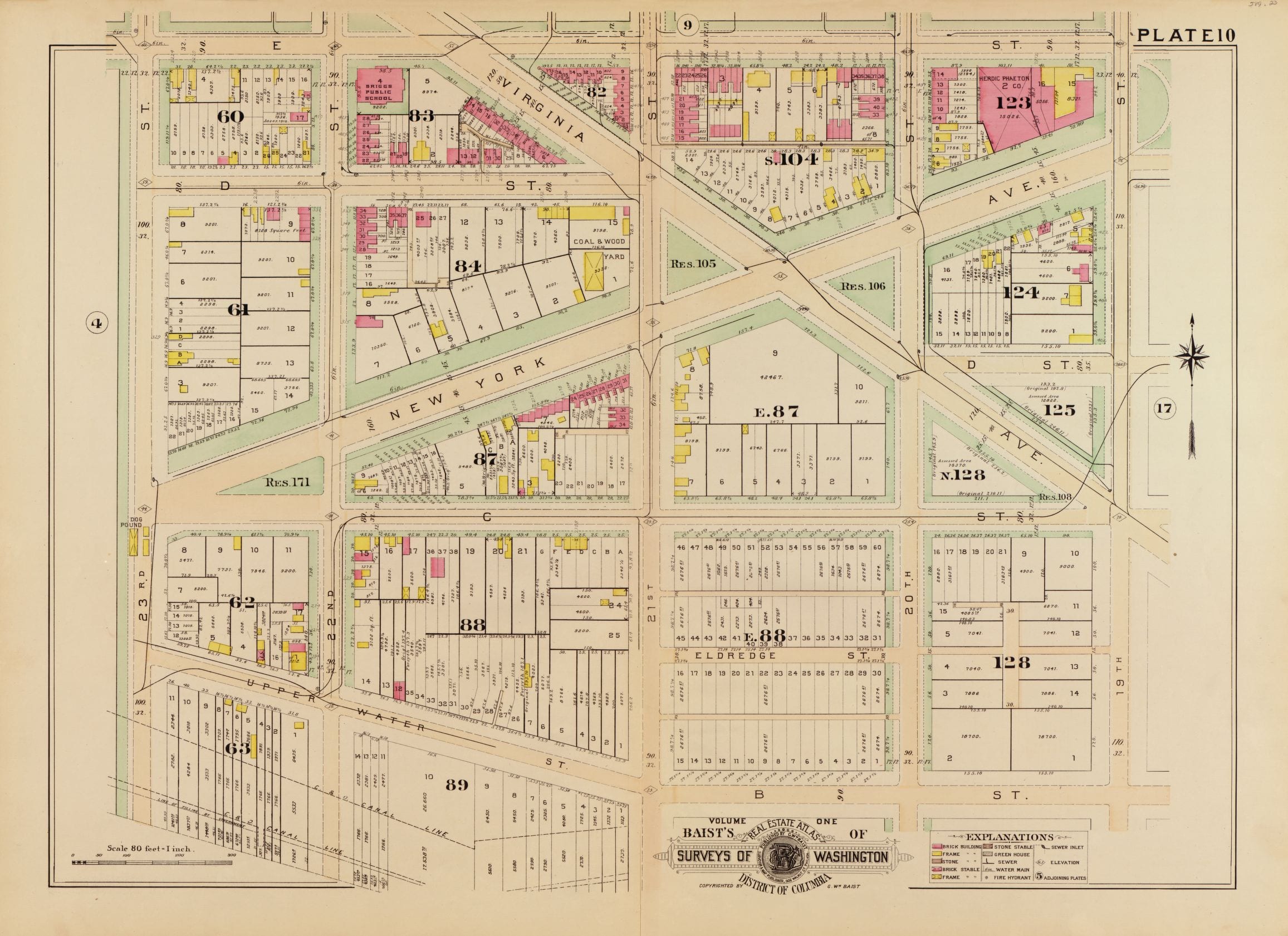
Take a look back in time to explore DC in 1903 with this map of the Department of State! See the dog pound at 23rd and C St. and the Herdic-Phaeton building at 19th and E St.

Categories GoDCers Love Maps Tags 1900s, Department of State, Foggy Bottom

Exploring the Area Around Union Market and Gallaudet University in 1907

December 8, 2021May 19, 2014 by ghostsofdc
1907 map of Gallaudet University

Take a journey back in time to 1907 with this map showing the area around Union Market and Gallaudet University. Learn more with this exploration of the past!

Categories GoDCers Love Maps Tags 1900s, Gallaudet University, Trinidad

A Look at the 1861 Civil War Map of the D.C. Area

December 8, 2021March 14, 2014 by ghostsofdc
District of Columbia and the seat of war on the Potomac (1861)

Take a look at this 1861 Civil War map of the D.C. area to explore the District’s history of war. Source: Library of Congress.

Categories GoDCers Love Maps Tags 1860s, The Civil War 1 Comment

Evolution of Carlin Springs Subdivision in Alexandria (Now Arlington County)

December 8, 2021March 13, 2014 by ghostsofdc
Plat of Curtis & Burdett's subdivision of Carlin Springs, Alexandria County, Virginia : 260 ft. above sea level

Take a look at the evolution of Carlin Springs Subdivision in Alexandria, now Arlington County. See a map from 1890 and compare it to a map from today. Visit the Library of Congress to learn more.

Categories GoDCers Love Maps Tags 1870s, Arlington VA 2 Comments

Exploring Washington in the 1850s: Mapping Buildings, Roads, and Rural Property

December 8, 2021March 12, 2014 by ghostsofdc
Entered according to Act of Congress in the year 1861, by D. McClelland, Blanchard & Mohun, Hugh B. Sweeny, and Thos. Blagden, in the Clerks Office of the District Court of the District of Columbia.

Take a journey back in time to 1850s Washington with this detailed map which marks all the buildings, roads, and rural property owners. Discover fascinating large plots of land outside Boundary Street with this map from the Library of Congress.

Categories GoDCers Love Maps Tags 1850s 1 Comment

Exploring East Capitol Street in 1888: A Map of Wood and Brick Buildings

December 19, 2021March 11, 2014 by ghostsofdc
1888 map of East Capitol St.

Explore East Capitol Street in 1888 with this historic map. Find wood and brick buildings from over a century ago. Discover a piece of DC history with this interactive map from the Library of Congress.

Categories GoDCers Love Maps Tags 1880s, Capitol Hill 3 Comments

Welcome to Map Week! Check Out This 1903 Map of Judiciary Square

October 23, 2021March 10, 2014 by ghostsofdc

Welcome to Map Week! Every morning, we’ll share a map with the GoDC community. Check out this great 1903 map of Judiciary Square, featuring the Pension Building and City Hall in the middle. Source: Library of Congress.

Categories GoDCers Love Maps Tags 1900s, Judiciary Square 2 Comments

Uncovering the Past: A Look at a Historic Map from the Harvard University Online Archives

November 27, 2021March 7, 2014 by ghostsofdc

Explore a piece of history with a fascinating map from the Harvard University online archives. Take a look back to explore the District of Columbia in the late 1800s.

Categories GoDCers Love Maps Tags 1930s

Exploring Washington DC in 1901: A Map of the District of Columbia

January 1, 2020March 6, 2014 by ghostsofdc
Portion of "Map of the District of Columbia" No. D-287, Commission on the Improvement of the Park System, 1901

Take a journey back in time and explore Washington DC in 1901 with this map of the District of Columbia. See what’s missing and what’s still there! Click to explore!

Categories GoDCers Love Maps Tags 1900s 1 Comment

A Rare 1795 Map of the Territory of Columbia and the City of Washington

December 7, 2021March 3, 2014 by ghostsofdc

Explore a rare map from 1795 showing the Territory of Columbia and the City of Washington surrounded by Maryland. Click to view a larger version and learn more about this piece of history.

Categories GoDCers Love Maps Tags 1790s 3 Comments
Older posts
Newer posts
← Previous Page1 … Page7 Page8 Page9 … Page19 Next →
© 2026 Ghosts of DC • Built with GeneratePress