
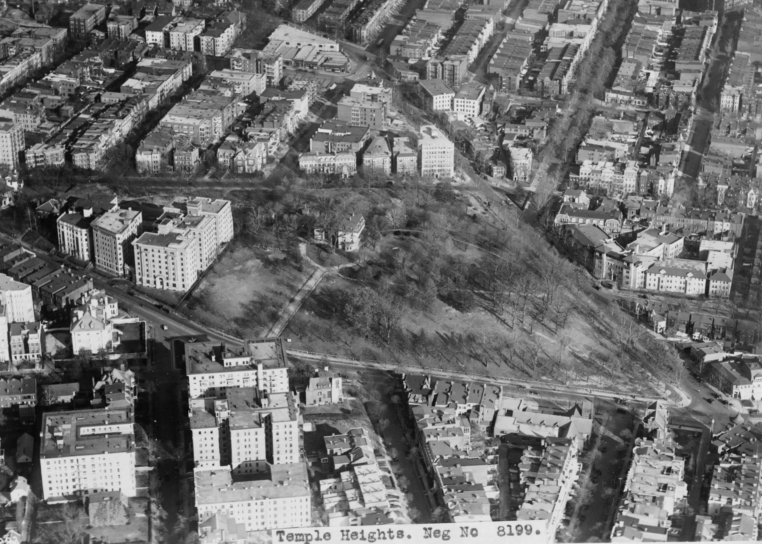
This is an aerial photograph of the empty, triangular, 10-acre parcel that used to sit between 19th Street, Columbia Road, Connecticut Avenue, and Florida Avenue NW. The lettering in the lower margin reads “Temple Heights, Neg No. 8199.” The photograph dates to the early 1930s.
The dense blocks around the edges are the apartment buildings of Kalorama and Adams Morgan, already mostly filled in. The green wedge in the middle is what was left of Oak Lawn.
Oak Lawn
The original house on the site was a modest Federal-style farmhouse built around 1820 by Colonel Michael Nourse. The Nourse family had acquired a 600-acre tract from the Holmead family, which stretched north from the edge of the developed city well into what is now Adams Morgan. In 1866 the 10-acre core of the estate, with its house, passed to Thomas P. Morgan, who in 1873 wrapped the original farmhouse in a four-story Second Empire mansion. He named the new place Oak Lawn after a single huge tree on the property called the Treaty Oak, said, probably without foundation, to have sheltered a 17th-century treaty between early settlers and the Nacotchtank.
The estate changed hands again in 1874, when Edward C. Dean, president of the Potomac Terra Cotta Company, bought it. For the next fifty years the property was known interchangeably as Oak Lawn or the Dean Estate. Around the turn of the 20th century, as Connecticut Avenue filled in with apartments and the surrounding blocks of Kalorama and Adams Morgan got platted and built, Oak Lawn became the conspicuous hole in the middle of the map: ten forested acres in the middle of downtown.
Temple Heights
In July 1922 a Masonic organization bought the Dean tract for $900,000. They promptly renamed it Temple Heights and announced plans to build, on that ten acres, a $3 million neoclassical complex with a central tower, flanking temples, and a 3,000-seat auditorium. The commission went to the prominent New York architect Harvey W. Corbett, who was already at work on the George Washington Masonic National Memorial rising in Alexandria.
The design ignored the District’s 1910 Heights of Buildings Act. The Masons applied for exceptions. The Commission of Fine Arts balked. The Federation of Citizens’ Associations objected. The project sat in hearings for most of the 1920s.
Approvals finally came in October 1929. The stock market crashed the same month.
The Masons held the land. They didn’t build. In the fall of 1940, Frank Lloyd Wright drew a glass city for the same hill and lost the same zoning fight. Through the Depression, through the New Deal, through the Second World War, the parcel stayed empty. Generations of Washington children tobogganed down its slopes in the winter. Mary Foote Henderson, operating her own monumental real-estate ambitions a few blocks east on 16th Street, wrote letters complaining about the Dean Estate’s weeds.
The aerial photograph in this post is what that long, stalled period looked like from the air. A green hole. Rowhouses marching up to its edges. The trees of Oak Lawn still visible in the middle, decades after anyone had lived there.
The Sale
In 1947 the Masonic group sold the land for $915,000, a nominal $15,000 above what they had paid twenty-five years earlier. In real terms they had lost fortunes.
The Oak Lawn house itself came down in April 1948. The Treaty Oak, allegedly four hundred years old, was felled in 1953 during construction preparation. Both removals happened without much ceremony.
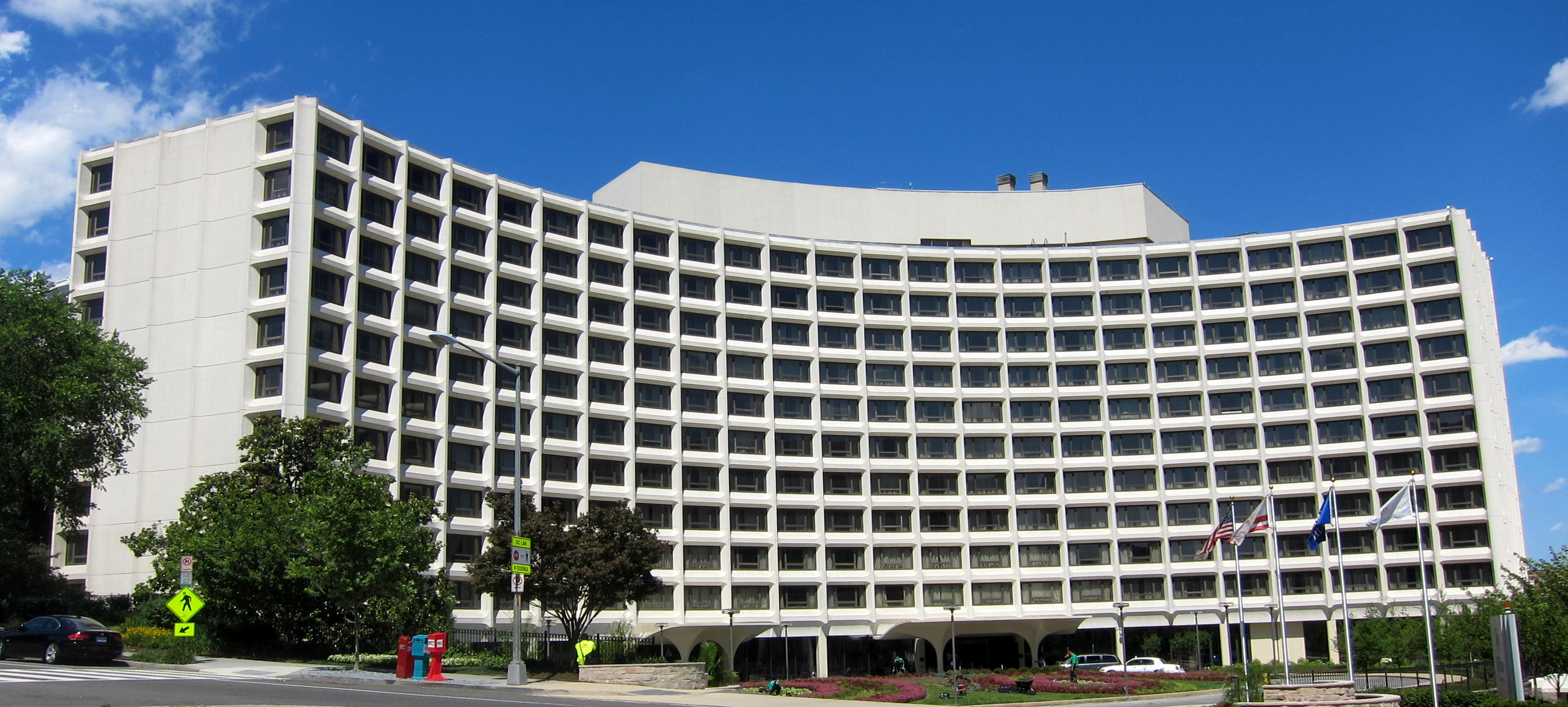
The Hilton
Groundbreaking for the Washington Hilton was held on June 25, 1962. The architect was William B. Tabler, the developer was Uris Buildings Corporation, and the design was pure mid-century Modern: a concave curving facade of precast concrete panels wrapping a column-and-slab concrete frame. The hotel had over a thousand rooms and an International Ballroom big enough to seat the whole Democratic or Republican National Committee with room to spare. It opened March 25, 1965.
For the next sixteen years it was one of the busiest convention hotels in Washington. The Beatles, touring the capital in February 1964, did not stay there, since construction was still underway. They stayed at the Shoreham.
March 30, 1981
Ronald Reagan gave a speech to the AFL-CIO’s Building and Construction Trades Department at the Washington Hilton on the afternoon of March 30, 1981. Coming out the side entrance onto T Street, walking to his limousine, he was shot by John Hinckley Jr. Press Secretary James Brady, Secret Service Agent Tim McCarthy, and DC Metropolitan Police Officer Thomas Delahanty were also hit. Six shots. About 1.7 seconds.
The side entrance where it happened is called “President’s Walk.” It now has an enclosed canopy for no one-walks-to-a-limousine reasons that are obvious in retrospect.
Since then, the hotel has been semi-affectionately known as the Hinckley Hilton.
One Parcel, Three Lives
Oak Lawn: a family house with a big oak tree.
Temple Heights: a Masonic dream that never got built because the owners took out too much leverage in 1929.
Washington Hilton: the convention hotel where a presidential assassination attempt happened on a Monday afternoon in 1981.
The aerial photograph in the middle of this post is the moment between lives. The Nourse farmhouse and Morgan’s Second Empire mansion were still standing. The Masonic complex had been drawn up and paid for and approved and then stopped. The Hilton was still thirty years away. The parcel was just a wedge of trees in the middle of the city, waiting.
Today the ten acres are under concrete, and the curving facade of the Hilton runs along the same property line where the Dean Estate fence used to run. When you drive north on Connecticut Avenue past Florida, you are passing the place where three entirely different Washington landmarks used the same dirt.
What WAS Oak Lawn? (If I’m orienting myself correctly – is that Conn Ave. in the foreground, meeting S Street on the lower right?)
Almost the site of a Frank Lloyd Wright development: Crystal Heights (Crystal City)
http://www.prairiemod.com/prairiemod/2009/08/what-might-have-been-crystal-city.html
http://pc.blogspot.com/2009/08/crystal-city-frank-lloyd-wright.html
I think that’s Conn. Ave. in the foreground, and Columbia Rd. heading to the upper left. 19th St. behind the land and Florida Ave. on the right. T St. heading off in the 1 o’clock direction.
Anyone know why it was called Temple Heights? Or Oak Lawn? I’ve always wondered why the post office at T and Florida was called the Temple Heights Station.
Most of the buildings pictured still exist. The Hilton and Universal Buildings are hideous. Though I’ve seen the images of FLW’s Crystal complex and am not a huge fan…I think they would have stood the test of time better than what was built.