
Long before there was a Washington, there were 40 stones.
A survey team led by Major Andrew Ellicott, with the free Black astronomer Benjamin Banneker at his side, planted them one every mile around the diamond-shaped boundary of the new federal district in 1791 and 1792. They are the oldest federally placed monuments in the United States, and 36 of the original 40 are still in the ground.
You can walk up to most of them today. A few are tucked behind iron fences planted by the Daughters of the American Revolution more than a century ago, sitting at the edge of a cemetery or in a quiet residential yard along the Maryland line, looking like nothing more than a worn chunk of sandstone. They are, in fact, the original corners of Washington, D.C.
A Diamond on the Potomac
The boundary stones exist because of the Residence Act of 1790, the congressional compromise that put the permanent capital on the Potomac River. The law gave President George Washington the authority to pick a 100 square mile site on either side of the river, “for the permanent seat of the Government of the United States.”
Washington picked a square. Ten miles on each side, oriented so that the corners pointed north, south, east, and west. On a map it shows up as a diamond.
The site straddled the river. The Maryland half held the planned City of Washington, Georgetown, and a chunk of countryside. The Virginia half pulled in Alexandria and the rolling land out past what is now Arlington and Falls Church.
To stake out a 100 square mile diamond, somebody had to survey it. Washington appointed three commissioners and put a Pennsylvania surveyor named Andrew Ellicott in charge of the field work.
The Survey Begins at Jones Point
On March 30, 1791, Washington issued a proclamation naming the southern point of the diamond. It was to sit at “Jones’s point, the upper cape of Hunting Creek in Virginia,” the southeast corner of old Alexandria where Hunting Creek meets the Potomac.
Two weeks later, the survey team showed up to plant the first stone.
On April 15, 1791, the Alexandria Masonic Lodge ran a Masonic ceremony to dedicate the south cornerstone at Jones Point. Ellicott was there. So were federal commissioners Daniel Carroll and David Stuart.
The stone went into the ground at the exact spot Ellicott had calculated as the corner of the future federal district.
That cornerstone is still there. It sits in the seawall just south of the Jones Point Lighthouse, a few feet from the Potomac, with the Woodrow Wilson Bridge looming overhead.
One small footnote on the cornerstone story. The original 1791 stone was replaced in 1794 by a slightly larger marker, which is the one in the seawall today. The dedication was first, the permanent stone came second.
Benjamin Banneker, the Astronomer Who Started the Survey
Ellicott did not run the survey alone. Among his assistants were his brothers Joseph and Benjamin Ellicott, Isaac Roberdeau, George Fenwick, Isaac Briggs, and a free Black astronomer from Maryland named Benjamin Banneker.
Banneker was 59 years old and largely self-taught. Ellicott hired him to run the astronomical observations that fixed the precise location of the south corner at Jones Point. The whole survey depended on getting that first point right, and the first point depended on Banneker’s stargazing.
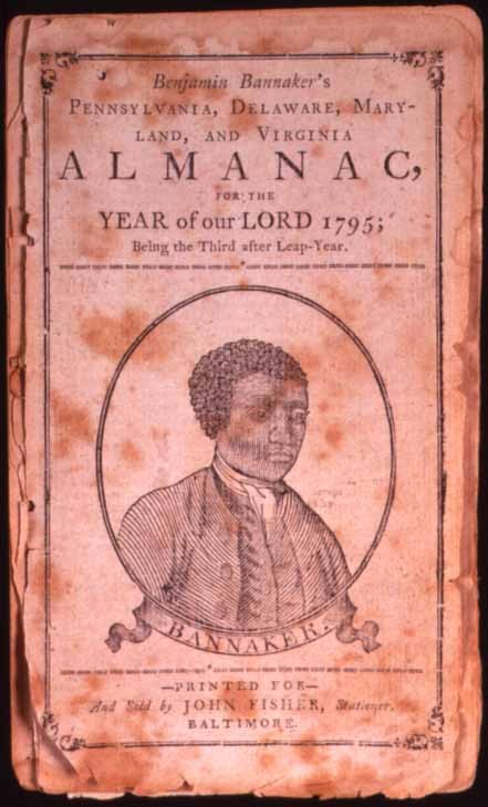
He worked through the bitter winter of 1791 at Jones Point, sleeping in an unheated tent and tracking stars across his observation window. By the time the team was ready to head out and plant stones around the rest of the boundary, his health had given out.
Banneker left the survey in April 1791 and returned to his farm in Maryland. He went on to publish his famous series of almanacs and to write the letter to Thomas Jefferson that pressed the question of slavery and Black intellect directly to the Secretary of State. The boundary stones are the marker he left on the ground in Washington.
How They Marked Each Mile
After Jones Point, the survey team cut a corridor through the woods and worked clockwise around the diamond. At each mile they planted a marker. Four cornerstones at the points of the diamond, 36 intermediate stones along the sides.
The stones were sandstone, quarried at the Public Quarry on Government Island near Aquia Creek in Virginia. The same quarry would later supply the stone for the White House and the original Capitol.
Most of the intermediate stones weighed about half a ton. The four cornerstones were slightly larger.
The Virginia stones went into the ground in 1791. The Maryland stones followed in 1792.
Each stone was inscribed on all four sides.
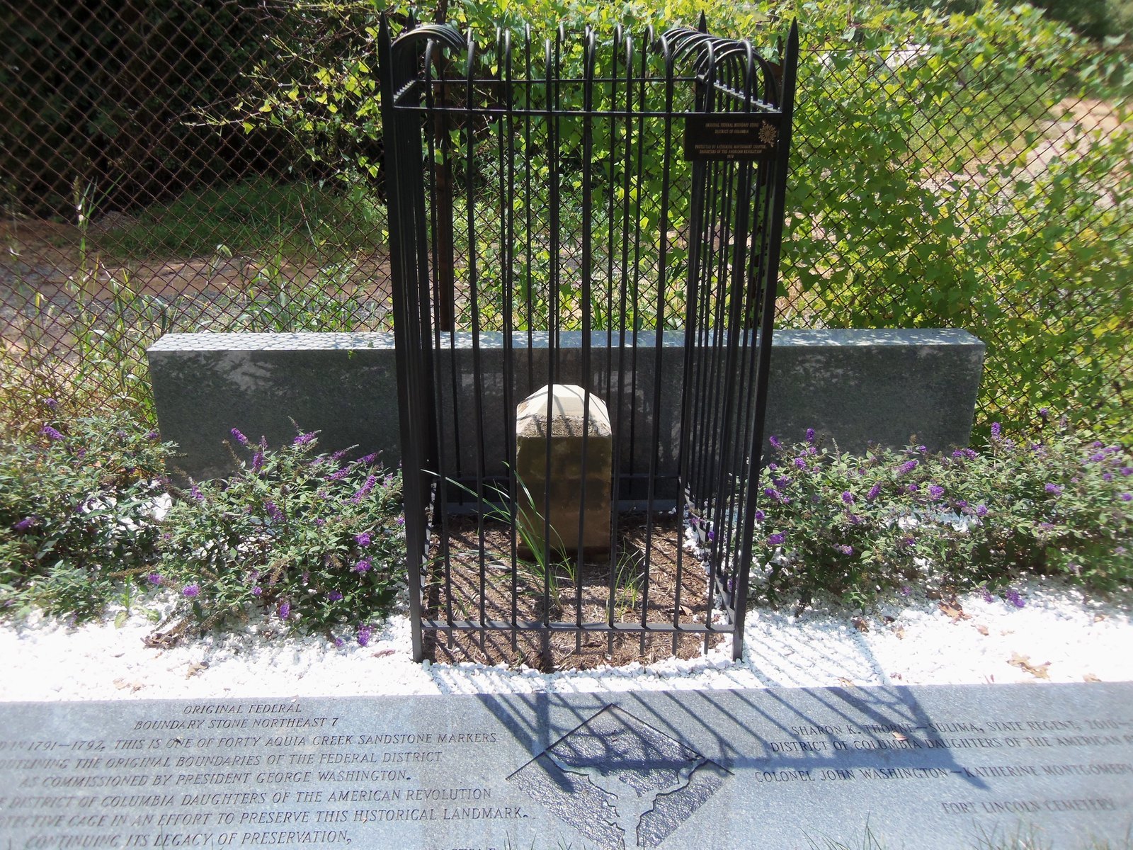
The side facing into the federal district read “Jurisdiction of the United States,” with the distance in miles and poles back to the previous corner. The opposite side, facing out, read “Virginia” or “Maryland.”
The third side carried the year, 1791 or 1792. The fourth carried the magnetic variation of the compass at that spot, recorded as “Var.”
On January 1, 1793, Andrew Ellicott reported to the commissioners that the survey was complete and every stone was in the ground. He filed a map showing the boundary, the major streets of the future City of Washington, and the location of every marker. The federal district had corners.
The Virginia Retrocession Cut the Diamond in Half
For about 50 years, all 40 stones did what they were placed to do. They marked the line where federal jurisdiction ended.
Then Virginia asked for its land back.
In 1846, Congress passed the District of Columbia retrocession, which returned the portion of the diamond south and west of the Potomac to the Commonwealth of Virginia. Alexandria and what is now Arlington went back. The stones along the southwest and northwest sides of the diamond, plus the south cornerstone and the west cornerstone, were no longer marking the boundary of D.C.
The original 40 became, technically, 13 stones in Virginia and 23 along the new D.C./Maryland line. The northeast cornerstone and the southeast cornerstone stayed on the active boundary.
The Virginia stones stayed in the ground, even though they no longer marked anything legal. That is why a walk around the original 1791 boundary takes you through three jurisdictions today.
Fred E. Woodward Goes Looking for the Stones in 1906
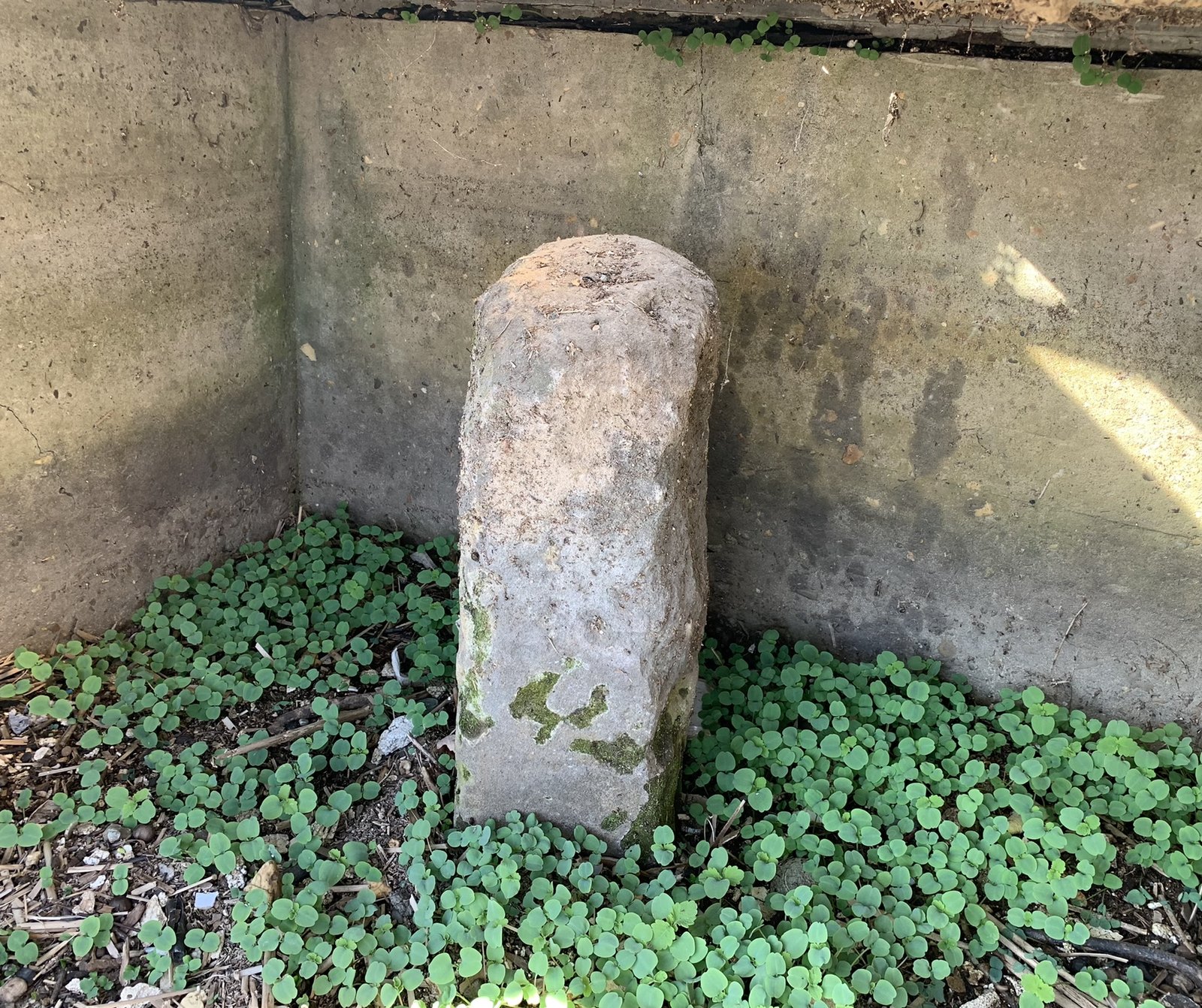
By 1906, the stones had been in the ground for 115 years. Some had been overgrown, undermined by road grading, knocked over, or sunk so deep they looked like ordinary fieldstone.
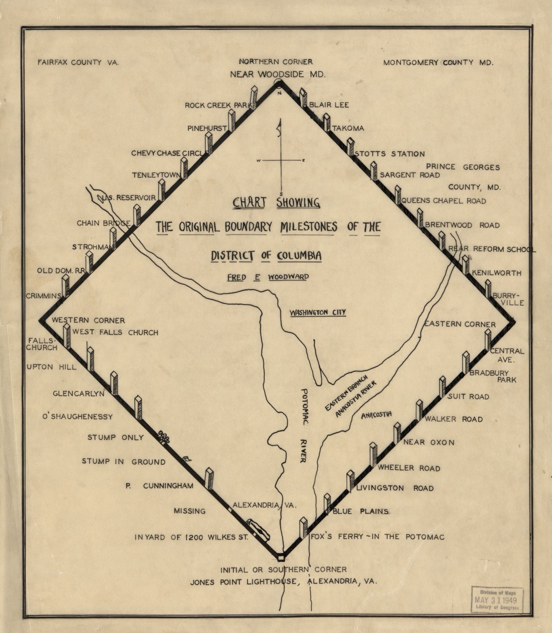
That year, Fred E. Woodward walked the entire boundary, photographed every surviving marker, mapped their locations, and wrote a paper for the Columbia Historical Society documenting the condition of each one. The “Records of the Columbia Historical Society,” Volume 10, published his findings in 1907.
The paper closed with a recommendation that read like a small civic alarm:
Important as these ancient boundary stones are to the historian or antiquary, they are singularly unprotected and should at once be safeguarded against further injury or damage other than the necessary exposure to the elements. Such protection might be afforded by a small enclosure about five feet square and five feet high, suitably made of wrought iron of approved national design, to be placed around each stone.
Woodward also produced a chart of every original boundary milestone, marking which stones still stood and which had been reduced to stumps. The Library of Congress has the original. It is the canonical map of the surviving boundary stones and the one we’ve featured at the top of this post.
Three years later, in 1909, USGS surveyor Ernest A. Shuster published an article in National Geographic Magazine reporting his own visit to the 36 remaining stones and pressing for the same thing: somebody, please, protect these.
The DAR Takes Over the Stones
In 1915, the Daughters of the American Revolution agreed to be the stewards.
Local DAR chapters began installing the small iron fences Woodward had proposed, one around each surviving stone. The fences were a uniform national design, and each chapter that adopted a stone got its name on a plaque. The dedications took place over 1916 and 1917, with the East Boundary Stone adopted by the DC DAR on April 15, 1916, the 125th anniversary of the original 1791 cornerstone laying.
The DAR also placed a marker stone at the calculated center of the original federal territory, about half a mile from the White House and near the DAR’s Memorial Continental Hall on 17th Street NW. That center stone is still there.
For most of the 20th century, that fence design and that volunteer stewardship were the only thing standing between the stones and the bulldozers.
The 36 Stones That Survived
Today, 36 of the original 40 boundary stones are still in the ground. Four are gone or have been replaced with substitute markers placed in the early 1900s.
The four corners are easy to find. The South Corner is the cornerstone in the seawall at Jones Point. The West Corner sits in Andrew Ellicott Park in Arlington, off North Arizona Street.
The North Corner is at East-West Highway in Silver Spring, Maryland. The East Corner is at Southern Avenue and Eastern Avenue, on the D.C./Prince George’s County line.
In between, the intermediate stones are scattered through every kind of setting Washington’s growth could throw at them.
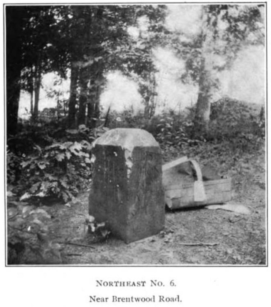
Northeast No. 2 stands in the front yard of a house at 6980 Maple Street NW in Takoma. Northeast No. 7 is along the fence line of Fort Lincoln Cemetery, southwest of the mausoleum.
Southeast No. 7 sits along a tree line at Indian Head Highway and Southern Avenue in Oxon Hill, Maryland. Southwest No. 7 is in someone’s back yard on South Manchester Street in Arlington.
Northwest No. 9 is at the edge of a Maryland subdivision, right where the diamond’s northwest line crossed what is now Western Avenue.
Most homeowners with stones on their property are happy to let people get a closer look if you ask. A few stones sit in parks. One is buried in the seawall.
The National Park Service, the District Department of Transportation, the Northern Virginia Regional Commission, and the local DAR chapters share stewardship today. All 40 stones, including the missing four, were added to the National Register of Historic Places in the 1990s.
The site at boundarystones.org is the best practical guide to finding each stone in person. It includes an interactive map, current photographs, and notes on what to look for at each location.
Southwest No. 9: The Banneker Stone
One stone has a name. Southwest No. 9, on the Virginia side of the diamond in Falls Church, is officially the Benjamin Banneker: SW-9 Intermediate Boundary Stone.
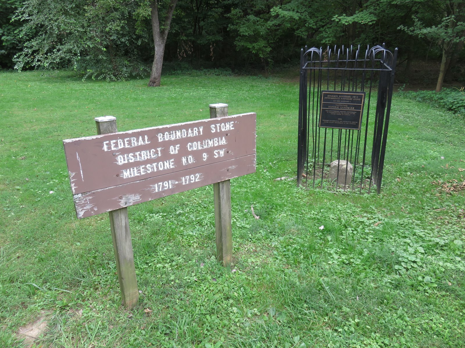
In 1976, the Afro-American Bicentennial Corporation pushed to formally tie one of the stones to the survey’s most famous member. SW-9 was selected, listed on the National Register of Historic Places, and named a National Historic Landmark that same year. It was the first boundary stone to receive the recognition.
The stone sits on the west side of Benjamin Banneker Park at 1701 North Van Buren Street in Falls Church. The DAR-style iron fence is still around it. The inscription has weathered down to ghosts of letters, but if you crouch and look at the right angle, you can still read “Jurisdiction of the United States” cut into the sandstone.
How Accurate Was the Survey?
In 2011, the D.C. GIS program ran a Global Positioning System survey of the original boundary at an accuracy of about two inches horizontally. They wanted to see how close Ellicott’s 1791 work had come to the modern measurement.
The answer was that Ellicott’s team did very well.
The northwest stones sit between 4.4 and 9.6 feet outside the modern boundary line. The northeast stones sit 6.6 to 18.4 feet inside. The southeast stones sit 12.75 to 18.48 feet outside.
The distance between Southeast 6 and Southeast 7, surveyed in 1792, measures 5,280.824 feet today. A statute mile is 5,280 feet.
Ellicott was off by ten inches over a mile, working with chains and stars.
That accuracy is why the stones are still the reference. The line they marked is, give or take a few feet, still the line.
The Diamond Is Still There, in Sandstone
Walk Western Avenue in upper Northwest and you are tracing the line Ellicott’s team cleared in 1792. Walk Eastern Avenue from Cedar Hill out to Maryland and you are tracing the line they cleared a few months before that. Drive South Glebe Road in Arlington and you are crossing what was the southwest face of the federal diamond.
The Virginia retrocession took half of the diamond off the map. The other half is the boundary D.C. still has.
Either way, the stones are still in the ground at every mile.
For the related GoDC story on the Virginia half of the diamond going back, see our piece on the 1846 retrocession of Alexandria. For the bigger story of how the L’Enfant city fit inside this diamond, the L’Enfant Plan posts are a good companion.
Two hundred and thirty-five years after Banneker laid down at Jones Point to fix the first point with stars, his stones are still the corners of Washington.
It’s interesting to see how big the original boundries of DC were so far into Virginia (and probably Maryland).
The boundaries haven’t changed. The Virginia portion, of course, was ceded back and is now Arlington County and Alexandria City.
For lots of cool information about the boundary stones, including photos, go to http://www.boundarystones.org/
You beat me to this. It is a great resources with articles and other cool things. The article “The Boundary Monuments of the District of Columbia” was my personal favorite because it has a lot of images of the stones from the turn of the century I think.
Have you ever visit any of the boundaries? My goal is to visit all one day.
I’d really love to. Have you or Mike?
There’s one on Southern Avenue. It’s in a fence and was right in front of an apartment building my cousin lived in, and down the street to where I lived on PA Ave years ago. It was never encased in the fence before they built the Apartments back in the 1960’s and people didn’t even know what it was. Then one day they put a fence around it.
Check out the Boundary Stones Bike Ride hosted by Boundary Stone Public House! The 3rd annual will be this September. You can start training for the 60 mile ride now. 🙂
I visit all 40 site in a day on the first Sunday in May and have done so for the last 10 years. Amazing and Educational. I could go on and on about the history of the survey, the history of the preservation effort, and the current status of each of the stones and what has transpired with them since 2005.
I discovered the stones back in the seventies while doing land surveys in Arlington. It was cool both visiting them and actually using and referencing them in my surveys.
I’ve been to a few. One on Western Avenue (“Tenleytown” in the map above) is actually on the Maryland side of Western Avenue a block from River Road, near Fessenden St., in a little cage to protect it from vandalism.