
Do you know why the county is named Arlington? How about Ballston?
I have a soft spot for Ballston. It is where I first lived when I moved to the area, so in tribute to my old neighborhood, I went digging into how it got its name.
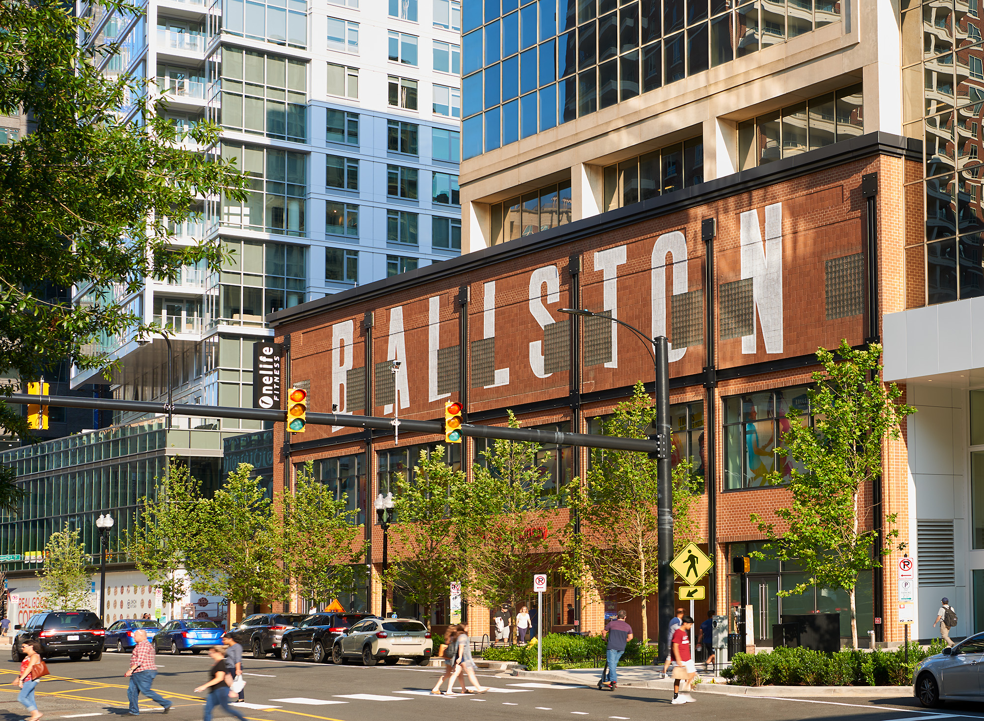
Stand at the corner of Glebe Road and Wilson Boulevard today and you are in one of the densest square miles in the Washington region. Glass towers, a Metro station, DARPA, a mall turned inside out.
The name on all of it traces back to a family of farmers and a two-story log tavern that once stood at this exact crossroads.
George Washington’s surveyor “cousin”
The Balls got here early. John Ball and his younger brother Moses, sons of John Ball of Stafford County, took up land along Four Mile Run in the 1740s. Moses patented 91 acres in 1748.
Their property line ran right up against a young surveyor’s tract. That surveyor was George Washington.
In 1775, Washington bought a 1,200-acre parcel he called Washington Forest, next to the Ball land near Carlin Springs. He and Moses Ball ran surveys together more than once. In his own diaries, Washington mentions Moses four times, and each time he calls him “cousin.”
Now, Washington was generous with the word. Historians note he called just about any Ball a cousin. Family tradition makes Moses a distant cousin of Washington’s mother, Mary Ball Washington, but nobody has ever proven it. What is not in doubt is that the two men knew each other, surveyed the same ground, and that Washington owned the tract next door.
The family left its mark all over the area. One John Ball built the one-room log house, with its sleeping loft, that still stands in Glencarlyn as the Ball-Sellers House, the oldest building in all of Arlington.
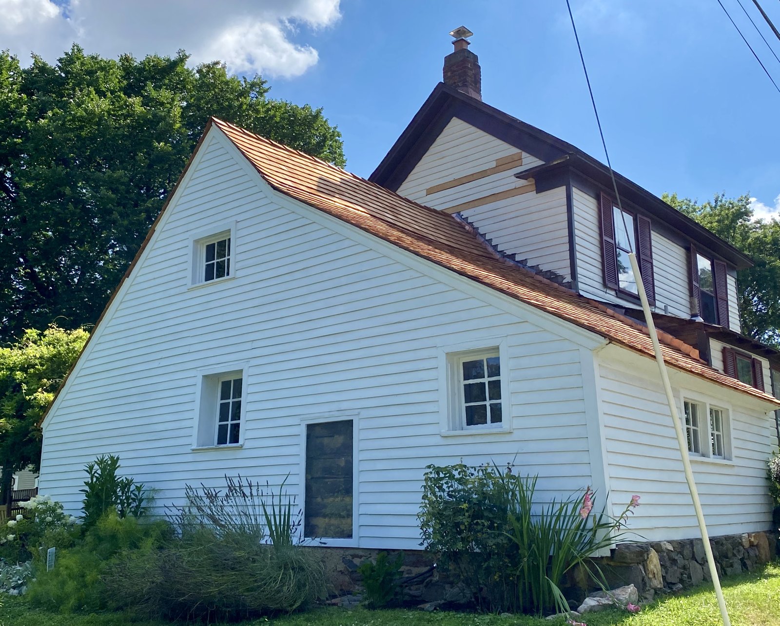
Moses had a son, also named John, because there are a lot of John Balls in this story. The younger John built his own log house in 1773 and then marched off to the Revolution as an ensign in the 6th Virginia. Ensign John Ball, who lived from 1748 to 1814, is buried in an old Ball family burial ground that still sits on Washington Boulevard, ringed by a modern neighborhood.
Birch’s Crossroads becomes Ball’s Crossroads
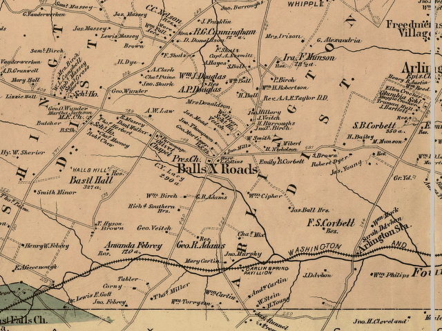
Here is the part the old histories, and an earlier version of this post, tended to blur. The crossroads was not always Ball’s.
It started as Birch’s Crossroads, after Joseph and Janet Birch, who owned much of the central and eastern ground here through the 1700s.
The two roads that crossed had drawn traffic since about 1740. One ran from the future site of Alexandria out to the mouth of Pimmit Run, and it picked up the name Glebe Road because it passed the glebe, the church farm, of Fairfax Parish. The other ran from a ferry landing at what is now Rosslyn to The Falls Church, and was later named Wilson Boulevard for President Woodrow Wilson.
Sometime in the early 1800s, a Ball descendant, probably a grandson of John or Moses, put up a two-story log inn at the southwest corner. Ball’s Tavern.
It became the center of everything. A gathering place, then a voting precinct, then a general store, and by 1896 a branch of the Georgetown post office. The tavern’s name crept out over the whole settlement, and shortly after the Civil War, everyone called it Ballston.
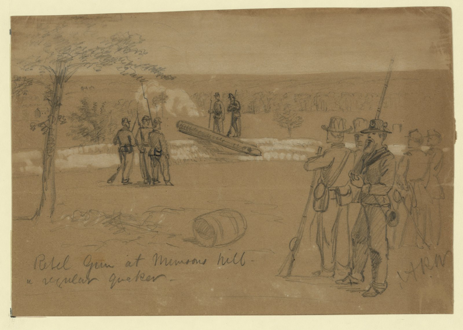
A skirmish at the crossroads
For a few weeks in 1861, this quiet farm corner sat on the front line of the Civil War.
After the Union rout at Bull Run that July, Confederate troops pushed east and dug in on Munson’s Hill and Upton’s Hill, within sight of Washington itself. The ground between the armies turned into no-man’s-land, and the pickets shot at each other almost nightly.
On August 27 and 28, the fighting around Ball’s Crossroads boiled into one of the largest clashes Arlington would see in the entire war. Newspaper accounts counted more than a thousand men in it.
A captain in the 23rd New York, William Dingleday, wrote home about it a few days later. His letter, dated “Arlington Heights, September 1st, 1861,” is the best seat in the house.
Between the hours of two and four p.m. the scouts and pickets came in double quick, with the intelligence that a large body of rebels were about to attack us… The firing then commenced in good earnest. The entertainment was brief but exceedingly interesting, and, after a short time, it was evident that the rebels were more anxious to retreat than our own men… We learned today from a lady whose residence is near where the conflict took place, that the rebels acknowledge a loss of eleven killed and many wounded. From her statement, they outnumbered us two to one, but were all under the influence of liquor, which proved a serious disadvantage to them. All is quiet now, however, and peace reigns again in Israel.
Generals McDowell, Keyes, and Wadsworth rode out to see what the fuss was about. By the end of September, the Confederates had slipped off Munson’s and Upton’s Hills in the dark.
When Union troops moved in, they found that some of the “cannons” aimed toward Washington had been logs painted black all along, the famous “Quaker guns.” The crossroads went back to being a crossroads.
The trolley the Orange Line still follows
Ballston was a transit town long before the Metro existed.
In 1896, the Washington, Arlington and Falls Church Railway strung electric wire along what is now Fairfax Drive and started running interurban trolley cars. Fairfax Drive took its name from where those cars were headed, Fairfax City.
A village called Central Ballston grew up around the line. By 1910 the railway had built a car barn, a railyard, workshops, and a power substation near Glebe Road and Fairfax Drive, and the west end of the neighborhood went by the name Lacey.
The Fairfax trolley shut down in 1939. Here is the part that should make any transit nerd sit up straight: when Metro’s Orange Line came through Arlington decades later, it ran the same route.
The corridor was built for rail before most of us were born. Metro just electrified the idea all over again.
Parkington, Hecht’s, and a chimp named Zippy
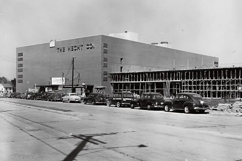
In 1951, the crossroads got something it had never seen before. A shopping center the size of a small airport.
It rose on the southeast corner, on the site of the old Ballston Stadium, where the semi-pro Ballston Skulls had played football and the Washington Redskins had held workouts back in 1938.
They called it Parkington, and the name was about as subtle as a billboard. The whole pitch was the parking. A four-tier garage, reputed to be the largest in the country, with stores tucked in underneath.
Hecht’s anchored it and opened on November 2, 1951. The five-story store got hailed as a “miracle of planning,” and it was the largest suburban retail space on the East Coast. The BBC actually sent a crew to film it as the future of American shopping.
For a couple of decades it was the place to be. In 1959 alone the center did $223 million in business. Hecht’s turned its three-story glass wall into a giant message board, 87 canvas panels stitched together for holiday greetings and civic causes.
And the famous people came. Abbott and Costello. Norman Rockwell. Charles Schulz. And, more than once, Zippy the Chimp, the roller-skating star of the Ed Sullivan and Howdy Doody shows.
One detail never made the brochures. When crews graded the ground for Parkington between 1949 and 1951, the old John Mills family cemetery, which had sat in a grove of trees on Glebe Road, disappeared during the work. Eleanor Lee Templeman’s 1959 history notes only that it was gone.
The Metro turns the corner
By the 1970s, Parkington was tired. The Washington Post called it “shabby.” The blocks around it had slid into what a 1979 Post article described as a “dreary collection of used car lots, small businesses and aging garden apartments.”
Arlington had a plan, and it was a bet. The county zoned for dense, mixed-use towers right on top of its future subway stops, chasing what its planners called growth “without urban blight.”
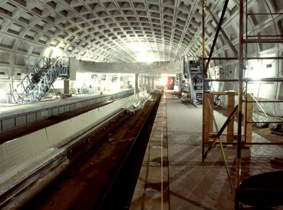
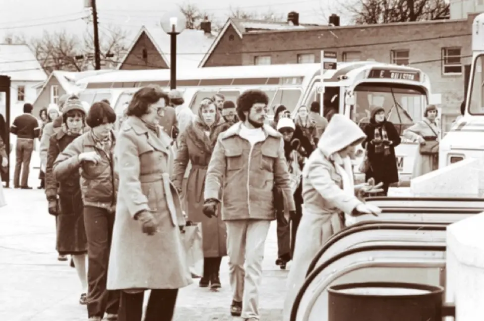
The Ballston Metro station opened on December 1, 1979, as the western end of the Orange Line. For about seven years it was literally the end of the line, until the trains pushed on to Vienna in 1986.
The bet paid off. A $13 million county investment in 1982 anchored a roughly $100 million overhaul of old Parkington, which reopened in October 1986 with a new name chosen in a local contest: Ballston Common.
The towers followed. Then DARPA, the Office of Naval Research, Accenture’s headquarters, and so many research outfits and agencies that Ballston became, by some measures, the densest neighborhood in the entire Washington region.
The crossroads is still a crossroads
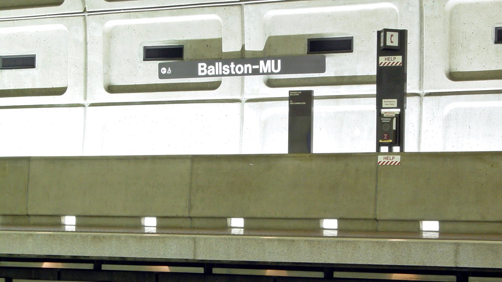
The mall has changed names again, to Ballston Quarter, and the Capitals practice on top of the parking garage now. The station picked up a second name, Ballston-MU, for the Marymount University campus next door.
But the bones are the same. Two old roads still cross at Glebe and Wilson. A Ball family graveyard still sits a short walk away, in the shade of the high-rises.
Two and a half centuries on, people still pull off at Ball’s corner to get their business done. The tavern just got a lot taller.
Surprised you didn’t mention Ballston’s time as Parkington.
Ballston was my first location, too, in 1985. I called it “the Ballston starter kit” because I felt I needed to get some grounding in the area before making the desired jump to DC.
And the Balls family is buried across from Ballston. Or was, the last time I was in that area.
One slight correction: during colonial times traffic heading east would have been going to Georgetown, then a commercial center. The city of Washington didn’t yet exist, and during the colonial period was farmland and some scattered houses.
Indeed. I lived in Arlington through most of the 1960s, and I never heard anyone use the name Ballston to refer to that area of the county during that time. The shopping center with the enclosed parking was called Parkington. I’m not sure which came first, Ballston Common or the Ballston Metro station, but I suspect it was the latter that started people calling the area Ballston. The same thing happened with Tenleytown; I never heard anyone call that part of Washington by that name until the Metro station opened, although, as with Ballston, the name has a long history.
anyone in the family ever named Harry?
The area has been referred to as Ballston since the late 1800’s. The Ballston Volunteer Fire Dept was formed in the early 1900’s and served the Ballston community. Geographically in Arlington the area of Ballston has been referred to as “Ballston” for as long as I remember. I have been in Arlington since 1963.
It’s been Ballston as long as I can remember. And it was a “rural” community for a long time. Just as Sterling and other communities were.
Nope, we never called it Ballston either. Not until the Metro came and we’ve been Arlingtonians since the 50’s.
The metro station opening preceded the mall redevelopment by a few years. (it’s likely the former caused the latter)
My own round trip on names is how I never heard anyone call the area around Drew school ‘Nauk’ growing up, just Green Valley. (and maps from the 40s and 50s use Green Valley vice Nauk). Though, of course, Nauk is an older name.
sorry, ‘Nauck’.
I was born in Ballston in 1942, on S. Stewart st. in a home across from the old firehouse. Moved in with my grandparents on Fairfax dr. when my father went into the service during WWll. That house was on the corner of Fairfax dr and Vermont st.. Part of Fairfax dr was still dirt.
It’s still there ~ I checked it out this summer!! My mother (a geneologist) had me find that “Ball Buring Ground” back in ’62 when I first lived in the area. At that time it was a mess ~ full of broken markers and beer cans ~ she had a fit and contacted someone in the area and the Kiwanis Club cleaned it all up and put up an historical marker and a large marker with the names of all those buried there. Some of the old headstones are still there over in a corner.
There’s a historic marker next to the church across Fairfax Dr from the metro station in the small plot of Ball graves.
Ballston MALL was Parkington. Ballston, the area, is not just a mall.