

You cannot take this picture today. The airspace over the White House has been a federal no-fly zone for decades, locked down tighter after September 11, 2001. So when you see the South Lawn, the West Wing, and the Old Executive Office Building from directly above, you are almost always looking at a photograph made before private aircraft were banned from the sky over 1600 Pennsylvania.
The Library of Congress holds a remarkable run of those photographs. Government photographers, the Harris and Ewing studio, the National Photo Company, and later Carol Highsmith all flew over the Executive Mansion and brought back images that, stacked in order, work like a flipbook of the property changing under each president.
Here are nine of the best.
The Earliest Known Aerial: Between 1909 and 1932
This bird’s-eye view from the National Photo Company is one of the earliest published aerial photographs of the White House. The Library of Congress dates the negative to sometime between 1909 and 1932. The Wright brothers had only flown publicly for the first time in 1908, and within a generation photographers were routinely aloft over the Executive Mansion with cameras.
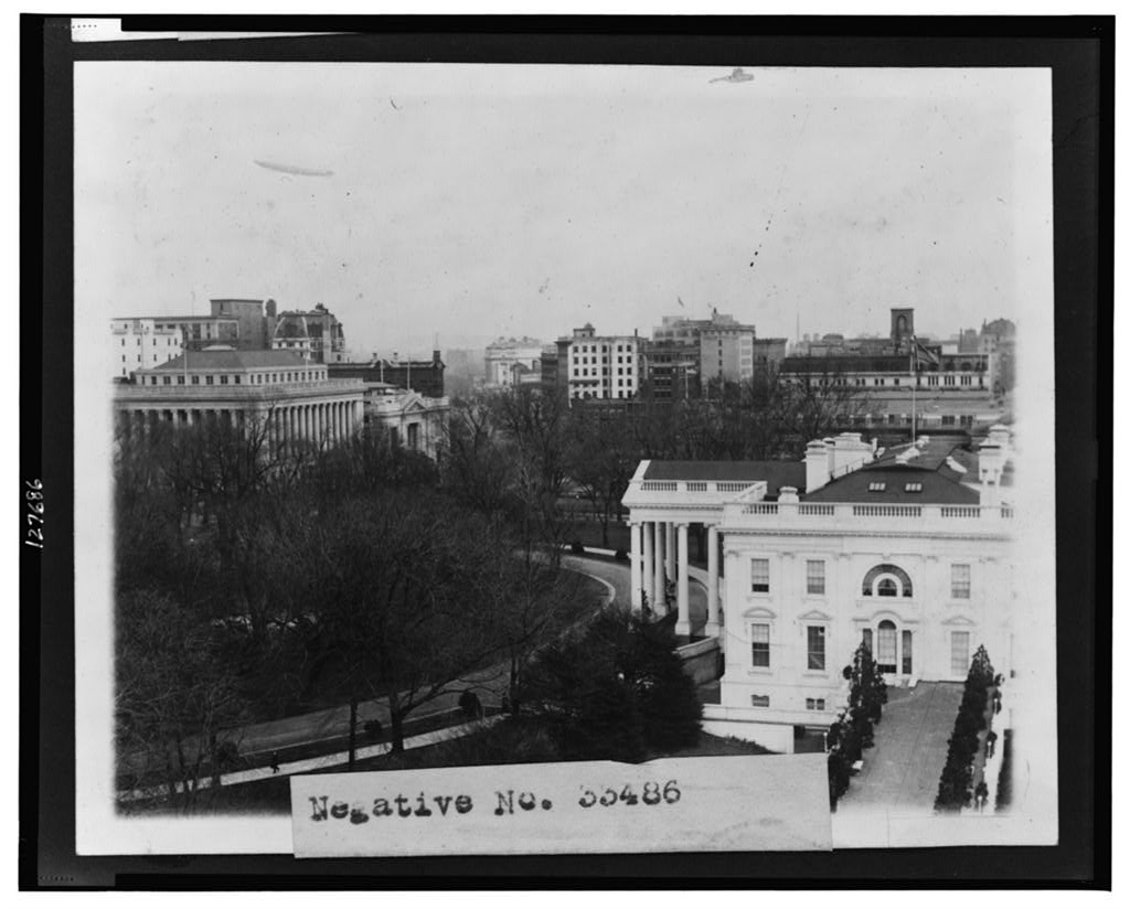
What jumps out is how much of the modern complex is already in place. The 1902 Theodore Roosevelt renovation, designed by McKim, Mead and White, had just added the original West Wing. The East Terrace, used by Roosevelt to clear out the family quarters for office staff, is already there. The Old Executive Office Building, finished in 1888, dominates the left edge of the frame.
The South Lawn looks empty by modern standards. There is no swimming pool, no helicopter pad, no tennis court, no Rose Garden in the form we recognize today.
Harris and Ewing, Between 1915 and 1923: The Mall in Black and White
By the mid-1910s, the commercial photography firm Harris and Ewing was sending its photographers up in aircraft and balloons over downtown Washington. This view, which LOC dates to sometime between 1915 and 1923, looks south across the White House grounds toward the Washington Monument, with the unfinished Lincoln Memorial site still raw at the far end of the Mall.
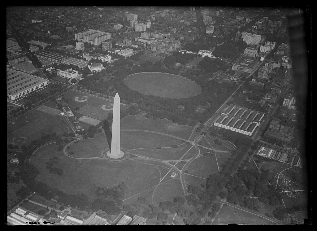
Look at the scale of the empty space between the monument and the river. The Reflecting Pool would not be completed until 1923. The Tidal Basin’s gates were operational by 1890; Congress designated the surrounding parkland in 1897, formally establishing what would become the Tidal Basin recreational area. This is Washington before the West Potomac Park monuments filled in.
The White House itself sits at the center, anchored by the South Portico Benjamin Henry Latrobe designed in 1817 and James Hoban completed under James Monroe in 1824.
The 1920s Aerials: Harris and Ewing Goes Aloft Regularly
In the early 1920s, Harris and Ewing photographers were over the White House often enough to capture both quiet days and presidential events from above. Two of their best aerials, made within months of each other during the Harding and Coolidge era, show the executive complex in sharp detail.
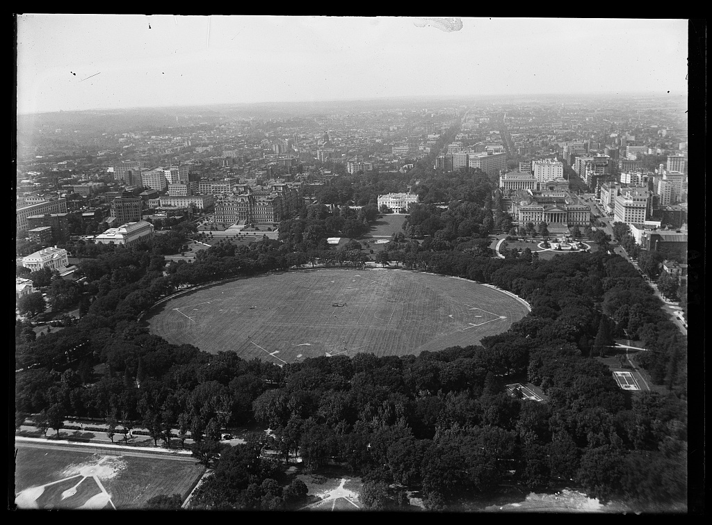
The first, looking down on the South Lawn, shows the property roughly the way it had stood for a generation. The original West Wing is still a low single story. The East Wing exists only as a coat-check terrace, not yet the working office space it would become.
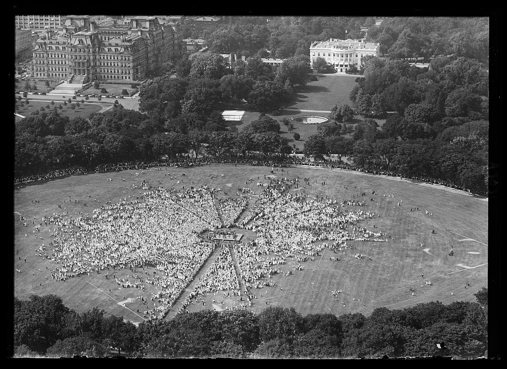
The second aerial shows a gathering in progress on the South Lawn, with carriages and automobiles drawn up along the curving south drive. Harris and Ewing was the most prolific Washington news photography studio of the era, and a slow-shutter aerial of a White House event was the kind of image their wire-service clients paid well for.
A few months later, in January or February 1922, the same studio brought back one of the most striking White House photographs in the LOC collection: the property under snow, photographed from directly above.
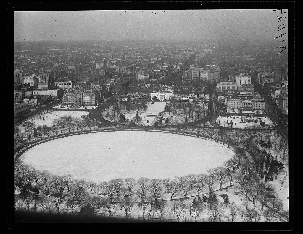
Almost nothing reads as 1922 in the picture except for the absences. There are no trees along the east colonnade. The South Lawn fountain is uncovered. The street between the White House and the Old Executive Office Building, now closed off as part of the security perimeter, is visible as a working public route.
1928: The City Around the House
By the late 1920s, Harris and Ewing was producing aerials that placed the White House inside the larger city, not as the only subject. This 1928 view looks north toward the property with downtown Washington stacked behind it.
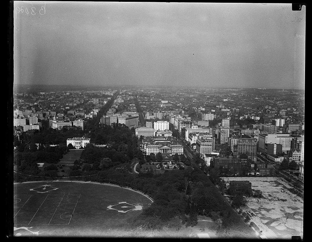
You can pick out the Treasury Department building immediately east of the White House, the rising bulk of Lafayette Square’s town houses to the north, and the spires of St. John’s Episcopal Church, the so-called Church of the Presidents.
The Department of Commerce building on Pennsylvania Avenue had not yet been constructed. The Federal Triangle that now fills the south side of the avenue was still the low-rise neighborhood once known as Murder Bay, the city’s nineteenth-century red-light district.
1934: Snow Again, FDR in the House
The next great Harris and Ewing snow aerial in the collection is from 1934, with Franklin Roosevelt a year into the presidency.
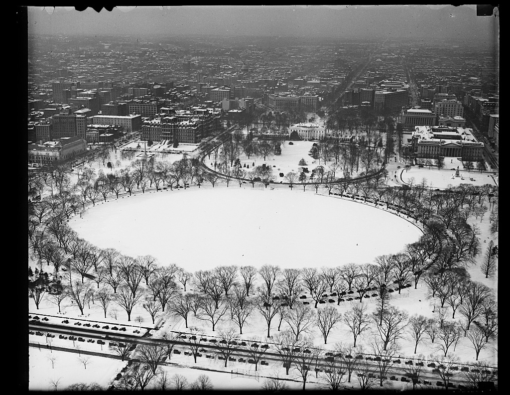
By this point the original West Wing had been expanded by Roosevelt’s predecessor Herbert Hoover, who used a 1929 Christmas Eve fire as the trigger for a quiet enlargement. FDR would push the next major expansion in 1934, moving the Oval Office to its current southeast corner location. The aerial, taken before that work began, shows the West Wing in its earlier footprint one last time.
The East Wing had not yet been built up either. That came in 1942, when FDR commissioned a second-floor addition partly to disguise the construction of the underground shelter that, decades later, became the Presidential Emergency Operations Center used on September 11.
The Hidden Era: The Truman Renovation, 1948 to 1952
There is a gap in the aerial record that matters. From late 1948 through early 1952, the White House interior was completely gutted and rebuilt. Engineers found the original 1817 timber framing dangerously overloaded by a century of additions, and Harry Truman moved across the street to Blair House while contractors stripped the building down to its exterior sandstone walls and rebuilt a steel structural skeleton inside.
From the air during those years, the South Lawn would have looked like a construction site, with the iconic exterior masking a hollow shell.
We covered that renovation in detail at Truman White House Renovation, 1949-1952: Interior and Exterior Photos, and you can see the building immediately before the gutting in A Rare Look at the White House Before the Truman Renovation.
Eisenhower’s Putting Green, Nixon’s Press Room
Two later changes are easy to spot in any aerial taken after 1969.
The first is the practice green Dwight Eisenhower added off the Oval Office in 1954, paid for by the United States Golf Association. It is still there, kept on as a quiet courtesy to the office by every president since.
The second is the swimming pool. Franklin Roosevelt’s indoor therapeutic pool, built in 1933 between the Residence and the West Wing, was covered over by Richard Nixon in 1970 to create the press briefing room you see today on television. The James S. Brady Press Briefing Room sits directly on top of the old FDR pool.
If you look at any post-1970 aerial, the briefing-room roof shows as a flat span between the West Wing and the Residence that earlier photographs do not have.
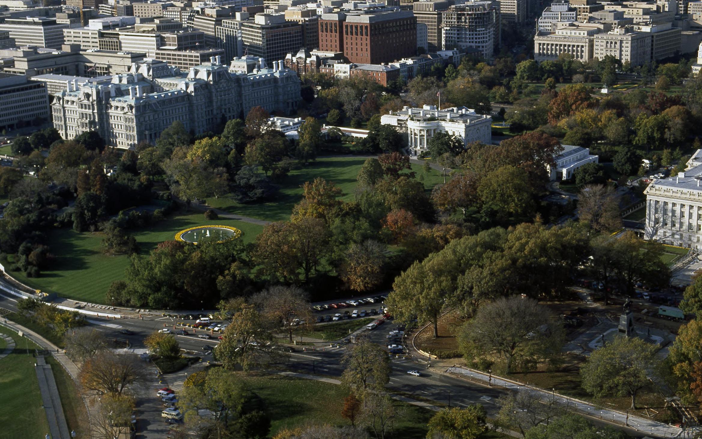
Modern Aerials: Highsmith and the Restricted Sky
After September 11, the FAA imposed a permanent flight restriction over the White House and the Capitol that pushed almost all aerial photography of the property into the hands of the federal government or its contractors. Carol Highsmith, the photographer whose decades-long archive sits in the Library of Congress for public use, captured the property from above during the looser pre-2001 period.
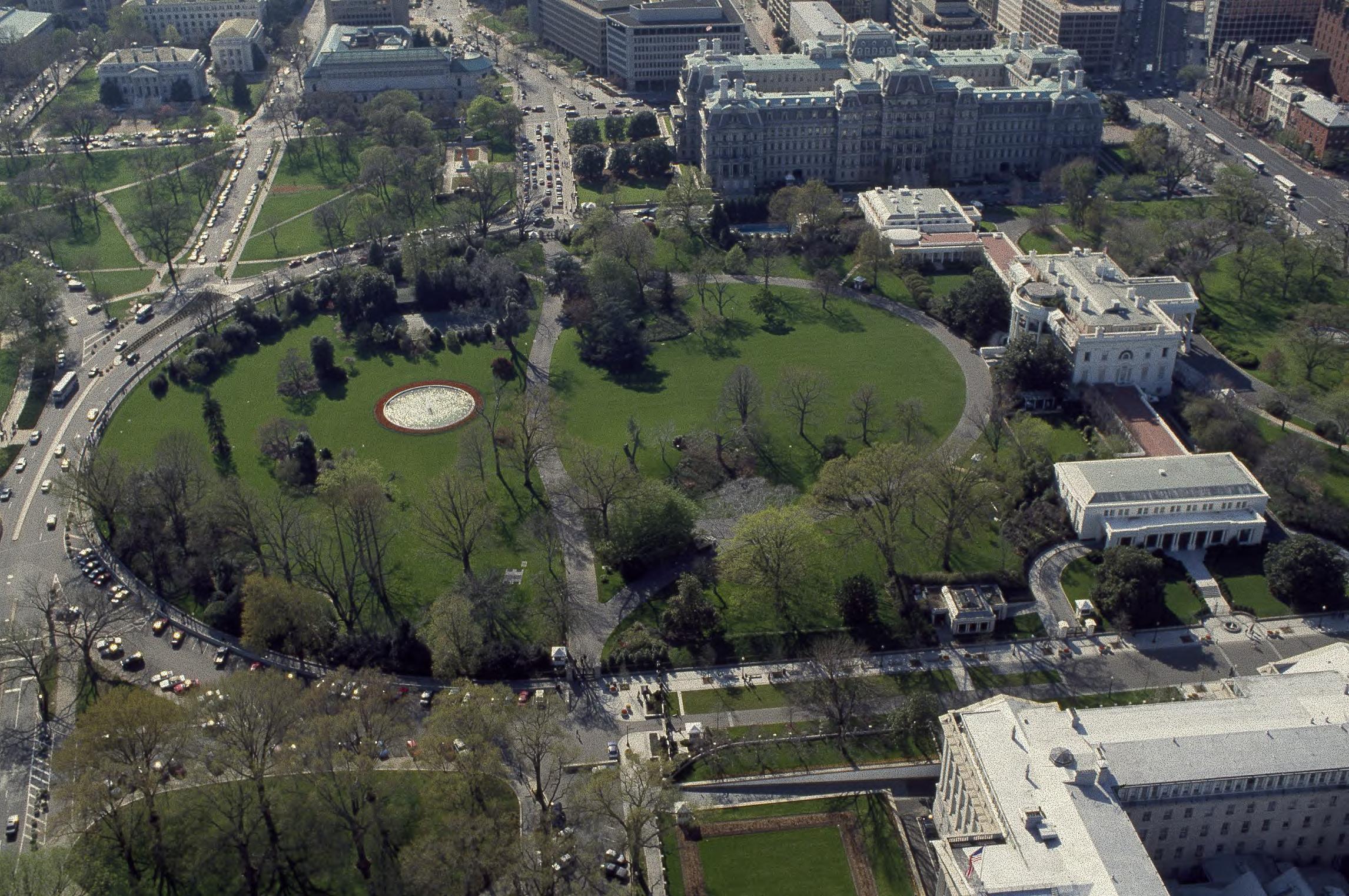
In her aerial, you can finally see the post-Truman, post-Nixon, post-Reagan property in one frame. The press briefing-room flat roof. The expanded East Wing. The Rose Garden as Jacqueline Kennedy and Bunny Mellon redesigned it in 1962.
The outdoor swimming pool that Gerald Ford installed in 1975 sits south of the West Wing. The Children’s Garden that Lady Bird Johnson commissioned in 1969 hides in the southeast corner.
A second Highsmith aerial, made on an autumn day with the trees in color, shows the East Wing in the form that stood until 2025. The Trump administration began demolishing the original East Wing in October of that year as the first phase of a planned ballroom expansion, a project we covered at The White House East Wing: From Jefferson’s Vision to a $250 Million Ballroom.
That Highsmith aerial may already be a historical document of a building that no longer exists.
Why You Cannot Take This Picture Today
If you tried to fly a Cessna over the White House today, you would be intercepted within minutes. After September 11, 2001, the FAA established a temporary Air Defense Identification Zone over Washington. That regime was replaced in February 2009 by the permanent Special Flight Rules Area, a thirty-nautical-mile ring centered on Reagan National in which general aviation must file flight plans, run transponders, and stay in contact with ATC. Inside that, a tighter Flight Restricted Zone covers central DC. Inside that, a prohibited area called P-56 covers the White House and the Capitol with the most absolute ban in the country.
The drone era did not loosen any of that. The FAA classifies the entire District of Columbia as a no-drone zone, and the Secret Service has authority to disable any unmanned aircraft that enters the airspace over the President’s residence.
Which is why the Harris and Ewing aerials from the 1920s, taken when a photographer could simply pay a pilot to circle the South Lawn at a thousand feet, are not just historically interesting. They are the only kind of view that will ever exist of the White House from directly above.
That’s an outstanding photo. Yes, it is rare, and will most likely be even more so from now on.
When was this pic taken? Thanx…..
I think in the 1980s.