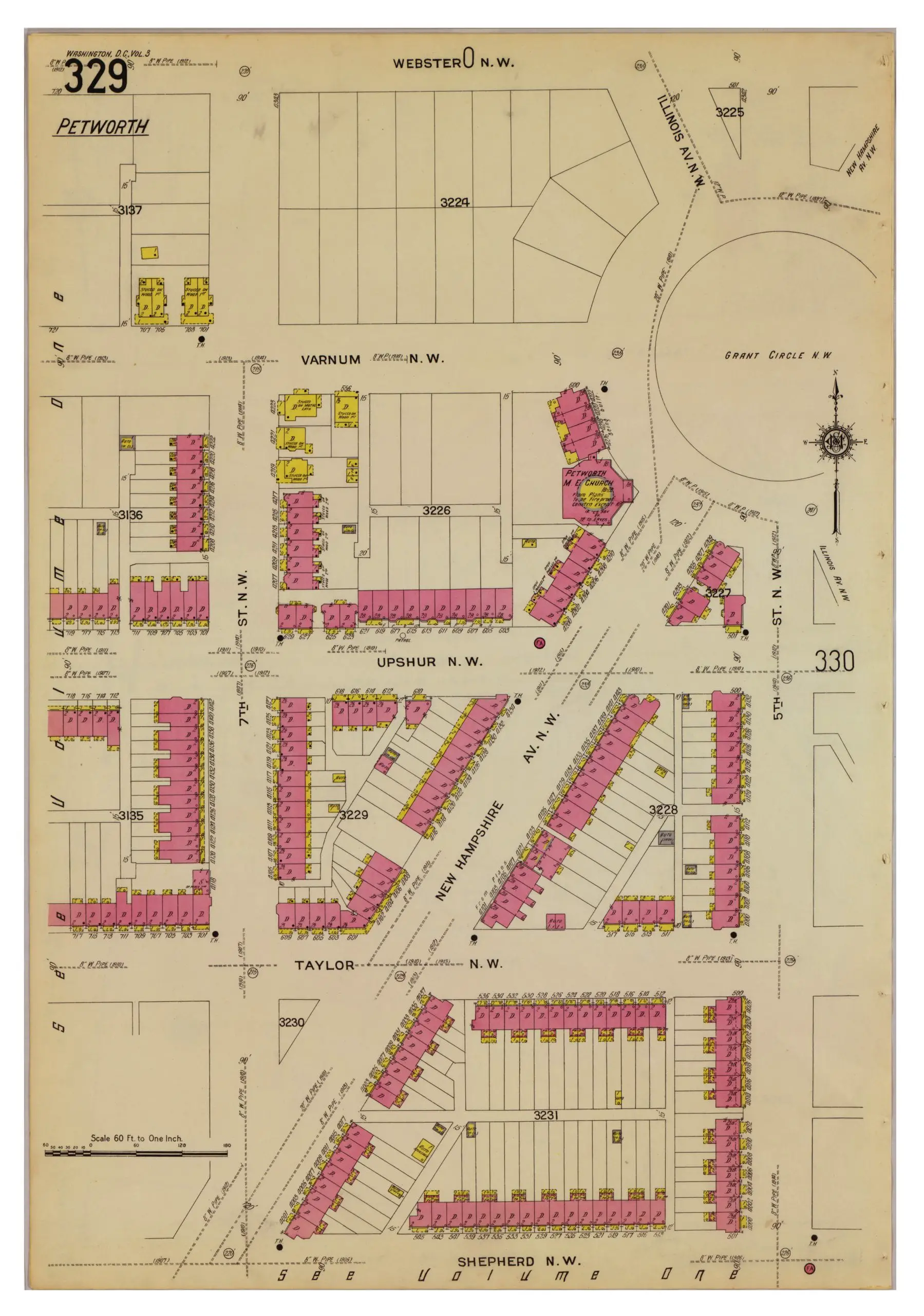
Neighborhoods
Northwest DC
Adams Morgan
Bloomingdale
Brightwood
Cathedral Heights
Chevy Chase
Chinatown
Cleveland Park
Columbia Heights
Crestwood
Dupont Circle
Friendship Heights
Glover Park
Logan Circle
Mt. Pleasant
The Palisades
Park View
Petworth
Sheridan-Kalorama
Tenleytown
Woodley Park
Georgetown
Northeast DC
Brookland
Deanwood
Trinidad
Woodridge
Southeast DC
Anacostia
Capitol Hill
Congress Heights
Navy Yard
Southwest DC
Waterfront
Maryland
Bethesda
Bladensburg
Gaithersburg
Hyattsville
Rockville
Silver Spring
Virginia
Alexandria
Arlington
Falls Church
McLean
Vienna
Lost Neighborhoods
Hell’s Bottom
Murder Bay
Swampoodle
Notable People & Places
People
Abraham Lincoln
Calvin Coolidge
Dwight D. Eisenhower
Warren G. Harding
John F. Kennedy
William McKinley
Franklin D. Roosevelt
Teddy Roosevelt
Officer Sprinkle
Woodrow Wilson
Places
The Capitol Building
Dulles Airport
Library of Congress
Washington Monument
The White House
The Best Of
Menu
Neighborhoods
Northwest DC
Adams Morgan
Bloomingdale
Brightwood
Cathedral Heights
Chevy Chase
Chinatown
Cleveland Park
Columbia Heights
Crestwood
Dupont Circle
Friendship Heights
Glover Park
Logan Circle
Mt. Pleasant
The Palisades
Park View
Petworth
Sheridan-Kalorama
Tenleytown
Woodley Park
Georgetown
Northeast DC
Brookland
Deanwood
Trinidad
Woodridge
Southeast DC
Anacostia
Capitol Hill
Congress Heights
Navy Yard
Southwest DC
Waterfront
Maryland
Bethesda
Bladensburg
Gaithersburg
Hyattsville
Rockville
Silver Spring
Virginia
Alexandria
Arlington
Falls Church
McLean
Vienna
Lost Neighborhoods
Hell’s Bottom
Murder Bay
Swampoodle
Notable People & Places
People
Abraham Lincoln
Calvin Coolidge
Dwight D. Eisenhower
Warren G. Harding
John F. Kennedy
William McKinley
Franklin D. Roosevelt
Teddy Roosevelt
Officer Sprinkle
Woodrow Wilson
Places
The Capitol Building
Dulles Airport
Library of Congress
Washington Monument
The White House
The Best Of
Support
-ad 626-
Published
March 20, 2013
in
GoDCers Love Maps
Grant Circle and Petworth in 1916
1916 map of Grant Circle and surrounding neighborhood of Petworth.
1910s
,
Grant Circle
,
Petworth
Search
-ad 188-
Share on facebook
Facebook
Share on twitter
Twitter
Share on pinterest
Pinterest
This is a set of maps from
1916
, showing a very different, and sparsely developed
Petworth
.
map of Grant Circle in 1916
-ad 197-
map of Grant Circle in 1916
READ:
Five Shot on 7th St. NW; Death Momentarily Expected
-ad 617-
Recommended for You
Drunk Guy Falls Off Key Bridge Railing
Mid-1990s Photo of Arlington
What Does DC Mean in Washington, DC?
What Is the History of CIA’s Langley Headquarters?
Babe Ruth Runs Into Wall; Knocked Unconscious
World War I Soldier Ogling Woman
D.C.’s Diagonal Street Names, Letters, and Numbers
Fire and Explosions Threaten to Destroy Rosslyn
-ad 618-
Today's Featured Posts
Arrival of First Japanese Embassy at the Navy Yard (1860)
1879 Map of Alexandria County
Interior Photos of Truman Reconstruction of White House
Photo of Hyattsville Hardware in 1940
Reader’s Choice: Why is Syracuse University in Woodley Park?
Incredible View of Memorial Bridge Under Construction
-ad 619-
Search
-ad 615-
Metro’s 17-Foot Long “Experimental Station” in 1968
Why Is It Named Trinidad?
Map of Washington Subdivisions in 1961
The Story of Russian Oligarch Oleg Deripaska’s Mansion
Street Car Extensions and a Columbia Heights Building Boom (1902)
Robert Todd Lincoln at His Father’s Memorial Dedication
Remember Au Pied de Cochon?
Video Visualizing Early Washington, D.C.
Abraham Lincoln in Color (1865)
Senior Prom at the White House
-ad 616-
Best of Ghosts of DC
Opening Dedication Ceremony of Dulles Airport in 1962
1886 Plan to Fill In and Build Over Rock Creek
1935 Map of Juvenile Delinquents in Washington
1891 Map of Street Sweeping
Mormon Temple Outside D.C.: Three Great Stories
Cool 1916 Bird’s-Eye View of Washington
-ad 189-