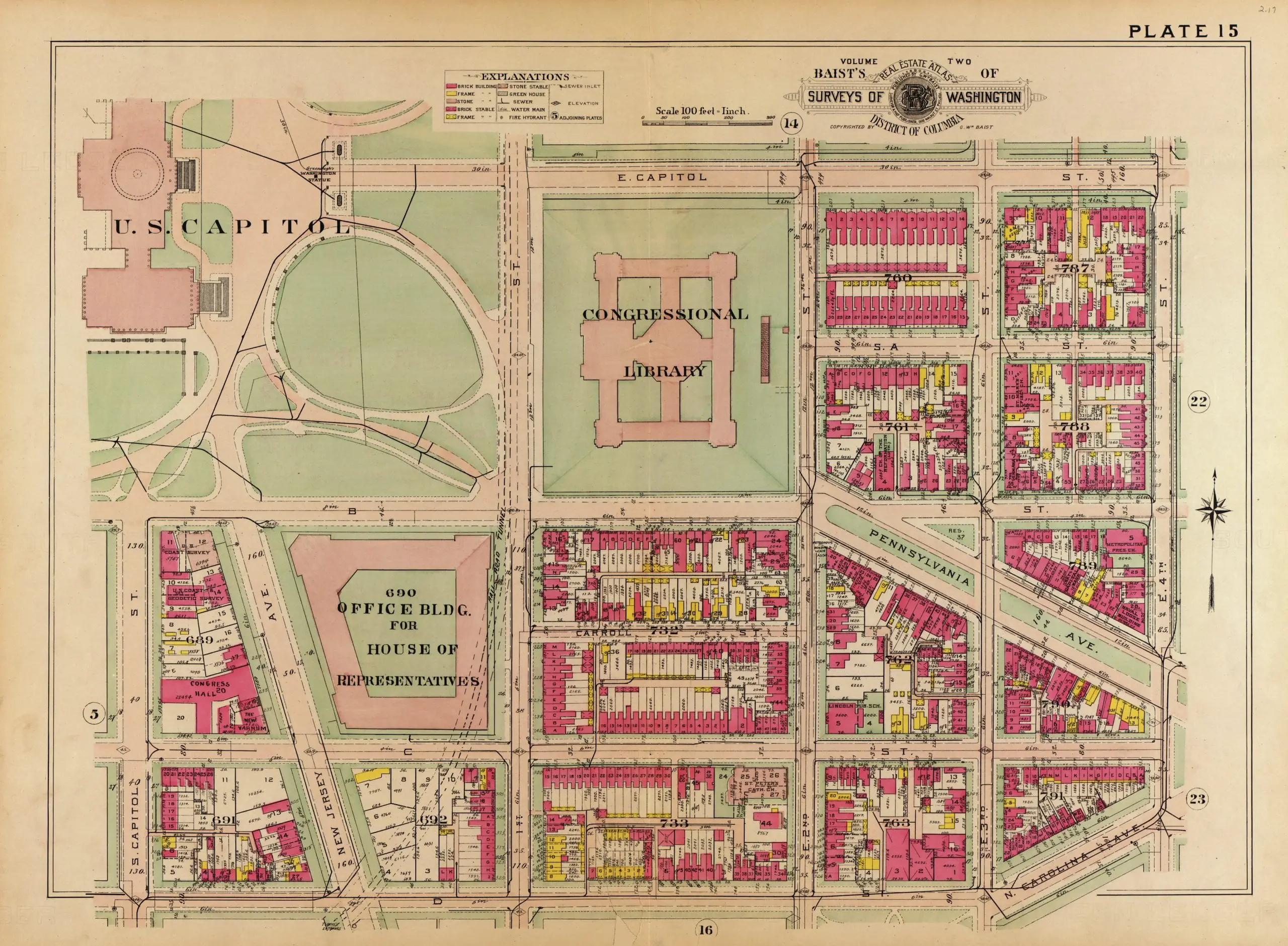
Skip to content
The Best Of
Neighborhoods
Southwest DC
Waterfront
Maryland
Gaithersburg
Rockville
Bethesda
Hyattsville
Silver Spring
Bladensburg
Virginia
McLean
Falls Church
Alexandria
Vienna
Arlington
Southeast DC
Congress Heights
Navy Yard
Capitol Hill
Anacostia
Northeast DC
Trinidad
Woodridge
Deanwood
Brookland
Northwest DC
Tenleytown
Park View
Friendship Heights
Brightwood
Crestwood
Sheridan-Kalorama
The Palisades
Logan Circle
Petworth
Glover Park
Bloomingdale
Georgetown
Woodley Park
Dupont Circle
Columbia Heights
Cleveland Park
Adams Morgan
Mt. Pleasant
Chevy Chase
Cathedral Heights
Chinatown
Lost Neighborhoods
Hell’s Bottom
Swampoodle
Murder Bay
Notable People & Places
Places
Washington Monument
Library of Congress
The White House
The Capitol Building
Dulles Airport
People
Franklin D. Roosevelt
Calvin Coolidge
Officer Sprinkle
Dwight D. Eisenhower
Warren G. Harding
William McKinley
Abraham Lincoln
John F. Kennedy
Teddy Roosevelt
Woodrow Wilson
Published
August 12, 2013
Exploring the Beauty of Old Baist Maps
Discover the beautiful old Baist maps of Capitol Hill. Learn more about the history of the region and take a look at the 1909 Baist map of Capitol Hill, sourced from the Library of Congress.
Exploring the Frozen Past: Walking on the Tidal Basin in the Early 1900s
Unveiling a Tacky Proposal to Finish the Washington Monument (Dated 1889)
No posts found
We love these old
Baist maps
.
1909 Baist map of Capitol Hill
Source:
Library of Congress
More For You
Why Is It Named Anacostia?
Fascinating Costumes and Facial Expressions from a Century Ago
No posts found
The Bizarre Incident Where a Man Took a Streetcar for an Illegal Joyride on Pennsylvania Ave.
Milking a Cow on the Capitol Grounds: An Odd Story from the Early 20th Century
No posts found
1890s Map of Diarrhea Deaths in Washington
Exploring the Washington Navy Yard Through an Old Plan From 1881
No posts found
Exploring the Development of Chevy Chase in 1907
A Look at a 1907 Map of Petworth
No posts found
If You're a D.C. History Nerd, You'll Find This Fascinating: A Look at the Capitol in 1814
Amazing View From Capitol Dome in 1863
Map of All D.C. Boundary Stones From 1906
No posts found
More 1964 Photos of The Beatles in Washington, D.C.
Glebe Road: History of Modern Day Arlington County
Why Is It Named Centreville?
No posts found
Metro's 17-Foot Long "Experimental Station" in 1968
Babe Ruth Runs Into Wall; Knocked Unconscious
1917 Film Footage of 180-Mile Journey Down Chesapeake and Ohio Canal
No posts found
Popular Posts
Where Was Murder Bay in Washington, DC?
No posts found
Exploring Washington's Lost Neighborhoods of the Late 19th Century
Three Sisters Island Legend in the Potomac
This Retro Metro Infomercial from the 1970s Is Amazing!
Metro Trains Were Almost Bright Red!
No posts found
Enjoy daily
Ghosts of DC stories.
SUBSCRIBE
No thanks.