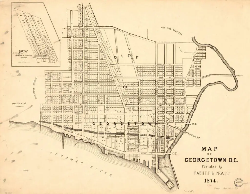
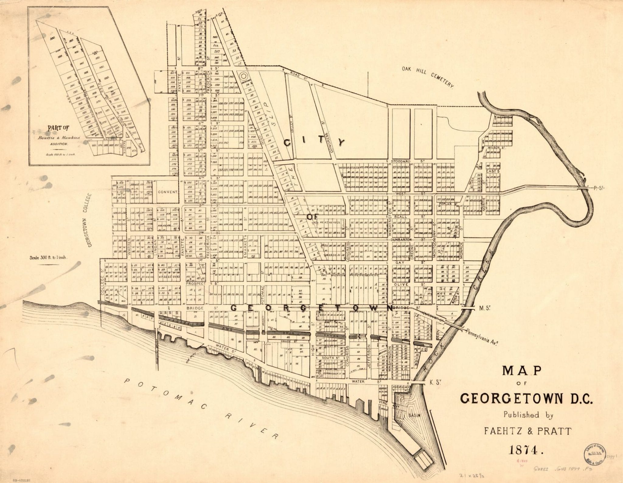
Neighborhoods
Northwest DC
Adams Morgan
Bloomingdale
Brightwood
Cathedral Heights
Chevy Chase
Chinatown
Cleveland Park
Columbia Heights
Crestwood
Dupont Circle
Friendship Heights
Glover Park
Logan Circle
Mt. Pleasant
The Palisades
Park View
Petworth
Sheridan-Kalorama
Tenleytown
Woodley Park
Georgetown
Northeast DC
Brookland
Deanwood
Trinidad
Woodridge
Southeast DC
Anacostia
Capitol Hill
Congress Heights
Navy Yard
Southwest DC
Waterfront
Maryland
Bethesda
Bladensburg
Gaithersburg
Hyattsville
Rockville
Silver Spring
Virginia
Alexandria
Arlington
Falls Church
McLean
Vienna
Lost Neighborhoods
Hell’s Bottom
Murder Bay
Swampoodle
Notable People & Places
People
Abraham Lincoln
Calvin Coolidge
Dwight D. Eisenhower
Warren G. Harding
John F. Kennedy
William McKinley
Franklin D. Roosevelt
Teddy Roosevelt
Officer Sprinkle
Woodrow Wilson
Places
The Capitol Building
Dulles Airport
Library of Congress
Washington Monument
The White House
The Best Of
Menu
Neighborhoods
Northwest DC
Adams Morgan
Bloomingdale
Brightwood
Cathedral Heights
Chevy Chase
Chinatown
Cleveland Park
Columbia Heights
Crestwood
Dupont Circle
Friendship Heights
Glover Park
Logan Circle
Mt. Pleasant
The Palisades
Park View
Petworth
Sheridan-Kalorama
Tenleytown
Woodley Park
Georgetown
Northeast DC
Brookland
Deanwood
Trinidad
Woodridge
Southeast DC
Anacostia
Capitol Hill
Congress Heights
Navy Yard
Southwest DC
Waterfront
Maryland
Bethesda
Bladensburg
Gaithersburg
Hyattsville
Rockville
Silver Spring
Virginia
Alexandria
Arlington
Falls Church
McLean
Vienna
Lost Neighborhoods
Hell’s Bottom
Murder Bay
Swampoodle
Notable People & Places
People
Abraham Lincoln
Calvin Coolidge
Dwight D. Eisenhower
Warren G. Harding
John F. Kennedy
William McKinley
Franklin D. Roosevelt
Teddy Roosevelt
Officer Sprinkle
Woodrow Wilson
Places
The Capitol Building
Dulles Airport
Library of Congress
Washington Monument
The White House
The Best Of
Support
-ad 626-
Published
March 5, 2019
in
Faces & Places of Yesterday
1877 Map of Georgetown
1870s
,
Georgetown
Search
-ad 188-
Share on facebook
Facebook
Share on twitter
Twitter
Share on pinterest
Pinterest
This is a great old map of Georgetown. Click on it for greater details.
-ad 197-
Source:
Library of Congress
READ:
Proposed National Zoo in Rock Creek Park
-ad 617-
Recommended for You
What Is the History of CIA’s Langley Headquarters?
What Did Petworth Look Like in the 1930s?
Shark Attacks in the Potomac in 1911?
Washington Monument Construction Photo From 1877
1967 Map of Unbuilt D.C. Highways
Photos of Columbia Heights After ’68 Riots
Photos of 1940s Boarding House Living
Lincoln Memorial Originally Built on Marsh Land
-ad 618-
Today's Featured Posts
U.S. Senate Imposes 50 Percent Tariff on Foreign Cars
Examining 1870s Photograph of Ford’s Theatre
Awesome West Front View of Capitol in 1908
1865 Photo of Alexandria Slave Pen
Sketches of Abraham Lincoln’s Assassination
For President, Abram Lincoln. For Vice President, Hannibal Hamlin
-ad 619-
Search
-ad 615-
Metro’s 17-Foot Long “Experimental Station” in 1968
Why Is It Named Trinidad?
Map of Washington Subdivisions in 1961
The Story of Russian Oligarch Oleg Deripaska’s Mansion
Wreck at Columbia Rd. and Sherman Ave. NW
Robert Todd Lincoln at His Father’s Memorial Dedication
Remember Au Pied de Cochon?
Video Visualizing Early Washington, D.C.
Abraham Lincoln in Color (1865)
Senior Prom at the White House
-ad 616-
Best of Ghosts of DC
Beautiful 1913 Night Photo of Pennsylvania Ave.
Fire and Explosions Threaten to Destroy Rosslyn
Anti-Flirt Club: Don’t Undress Me With Your Eyes
Murder Bay, the Rough-and-Tumble Lost Neighborhood
Why Is It Called Chain Bridge?
History of the Drinking Age in Washington, D.C.
-ad 189-