Skip to content
The Best Of
Neighborhoods
Southwest DC
Waterfront
Maryland
Gaithersburg
Rockville
Bethesda
Hyattsville
Silver Spring
Bladensburg
Virginia
McLean
Falls Church
Alexandria
Vienna
Arlington
Southeast DC
Congress Heights
Navy Yard
Capitol Hill
Anacostia
Northeast DC
Trinidad
Woodridge
Deanwood
Brookland
Northwest DC
Tenleytown
Park View
Friendship Heights
Brightwood
Crestwood
Sheridan-Kalorama
The Palisades
Logan Circle
Petworth
Glover Park
Bloomingdale
Georgetown
Woodley Park
Dupont Circle
Columbia Heights
Cleveland Park
Adams Morgan
Mt. Pleasant
Chevy Chase
Cathedral Heights
Chinatown
Lost Neighborhoods
Hell’s Bottom
Swampoodle
Murder Bay
Notable People & Places
Places
Washington Monument
Library of Congress
The White House
The Capitol Building
Dulles Airport
People
Franklin D. Roosevelt
Calvin Coolidge
Officer Sprinkle
Dwight D. Eisenhower
Warren G. Harding
William McKinley
Abraham Lincoln
John F. Kennedy
Teddy Roosevelt
Woodrow Wilson
-ad 189-
Published
January 23, 2018
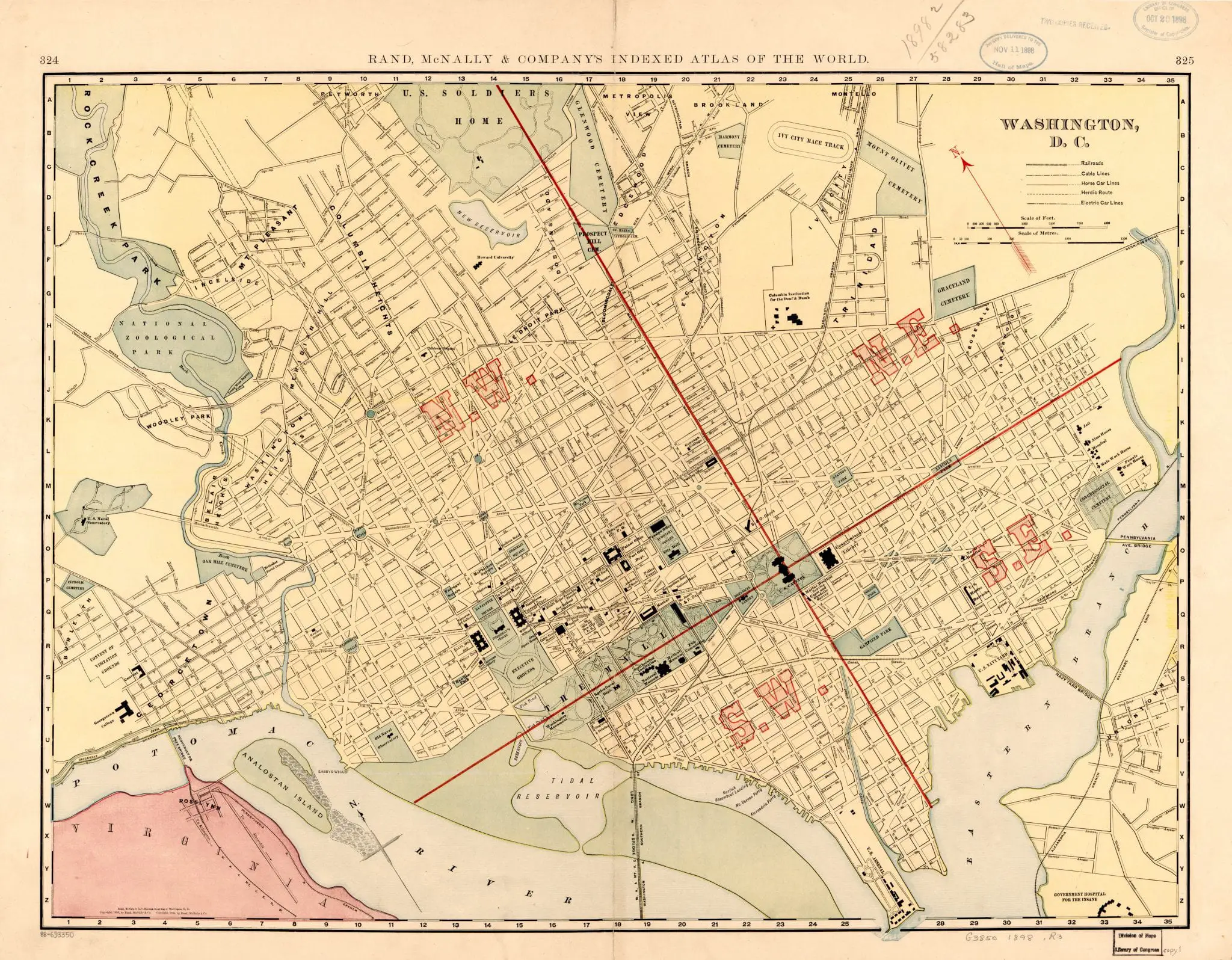
A Look at Washington, DC in 1898 Through a Historic Rand McNally Map
Take a look back in time to 1898 with this historic Rand McNally map of Washington, DC. Get a glimpse of the city as it was over 100 years ago.
50 Years Ago Today: The Washington Post Printed an Article on the Upcoming State Visit of West Germany's Chancellor
Uncovering the History of Phoebe Hearst Elementary School
No posts found
-ad 188-
This terrific old map of Washington by Rand McNally is from 1898.
1898
Washington, DC
Source:
Library of Congress
-ad 617-
More For You
A Glimpse Into the Past: Park View in 1924, Captured Just Before Thanksgiving
Exploring the Historic National Hotel: Where Presidents, Assassinations, and Dueling Were Once Plotted
No posts found
A Rare Photo of the Potomac River from 1898
Imagine Living Blocks from Adams Morgan's 18th Street and Owning a Home for $8,500 - Even in Today's Dollars!
No posts found
Uncovering the Opium Den Scene in Washington DC in 1894
Exploring Washington Before the Retrocession of the Western Portion to Virginia
No posts found
1847 Map of Washington
Exploring an 1874 Map of Mt. Pleasant and Columbia Heights Before the Streets Were Renamed
No posts found
Petworth in the 1930s
A Trip Down Memory Lane - Exploring the "Lawyers' Row Block" in Arlington from the Early 1990s
Why Is It Named Ballston?
No posts found
-ad 615-
Who Was Frank Morris? He Escaped Alcatraz.
A Closer Look at Thomas Circle in the 1920s
Au Pied de Cochon: D.C.'s Iconic Culinary Landmark
No posts found
-ad 616-
A Bird's Eye View of Washington, Looking Toward the Northeast
Senior Prom at the White House
Metro's 17-Foot Long "Experimental Station" in 1968
No posts found
-ad 630-
Popular Posts
Dulles Airport Opening Dedication Footage From 1962
No posts found
A Rare Look Back: The Lincoln Memorial in 1917 During Construction
When Did Metro Open in D.C.?
Washington Was Originally Named Rome, Maryland
Hear the Voice of Walter Johnson, The Greatest Pitcher of All Time
No posts found
Enjoy daily
Ghosts of DC stories.
SUBSCRIBE
No thanks.
x