
If you have ever wondered why Columbia Heights breaks the alphabetical letter-pattern that orders the rest of Washington north of Florida Avenue, the answer is that for two decades it was a different neighborhood entirely. Its streets carried the names of generals, asphalt magnates, and Eastern colleges.
Then in the summer and fall of 1905, the District Commissioners published a schedule of changes that rewrote almost the whole map.
The neighborhood lost most of its original names across two announcements three months apart.
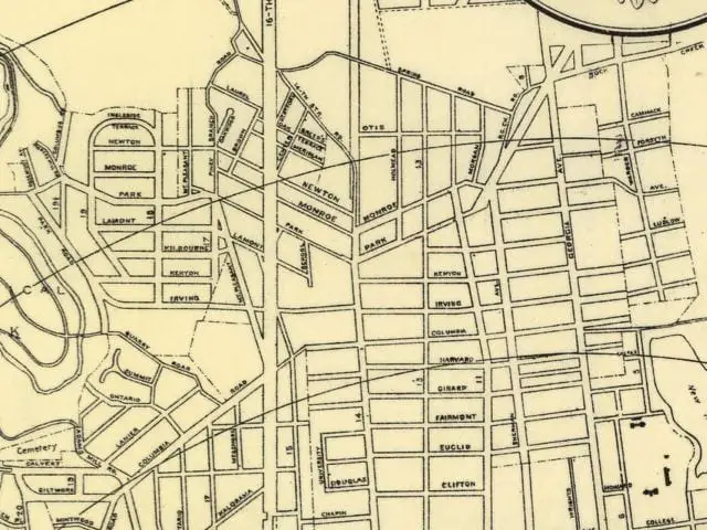
The map that does not match
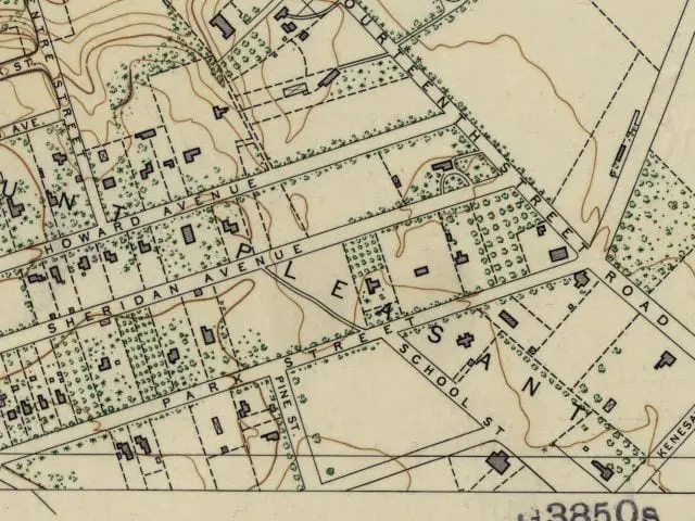
Pull up an 1892 to 1894 U.S. Coast and Geodetic Survey of Columbia Heights and the street names look wrong. Kenesaw Avenue runs where Irving Street is now. Whitney Avenue is Park Road. Howard is Newton, Sheridan is Monroe, and Lydecker is Monroe too. Yale, Harvard, Princeton, and Dartmouth march in a row through what is now Fairmont, Girard, and the streets nearby.
Only Meridian and Harvard and Kenyon survived intact.
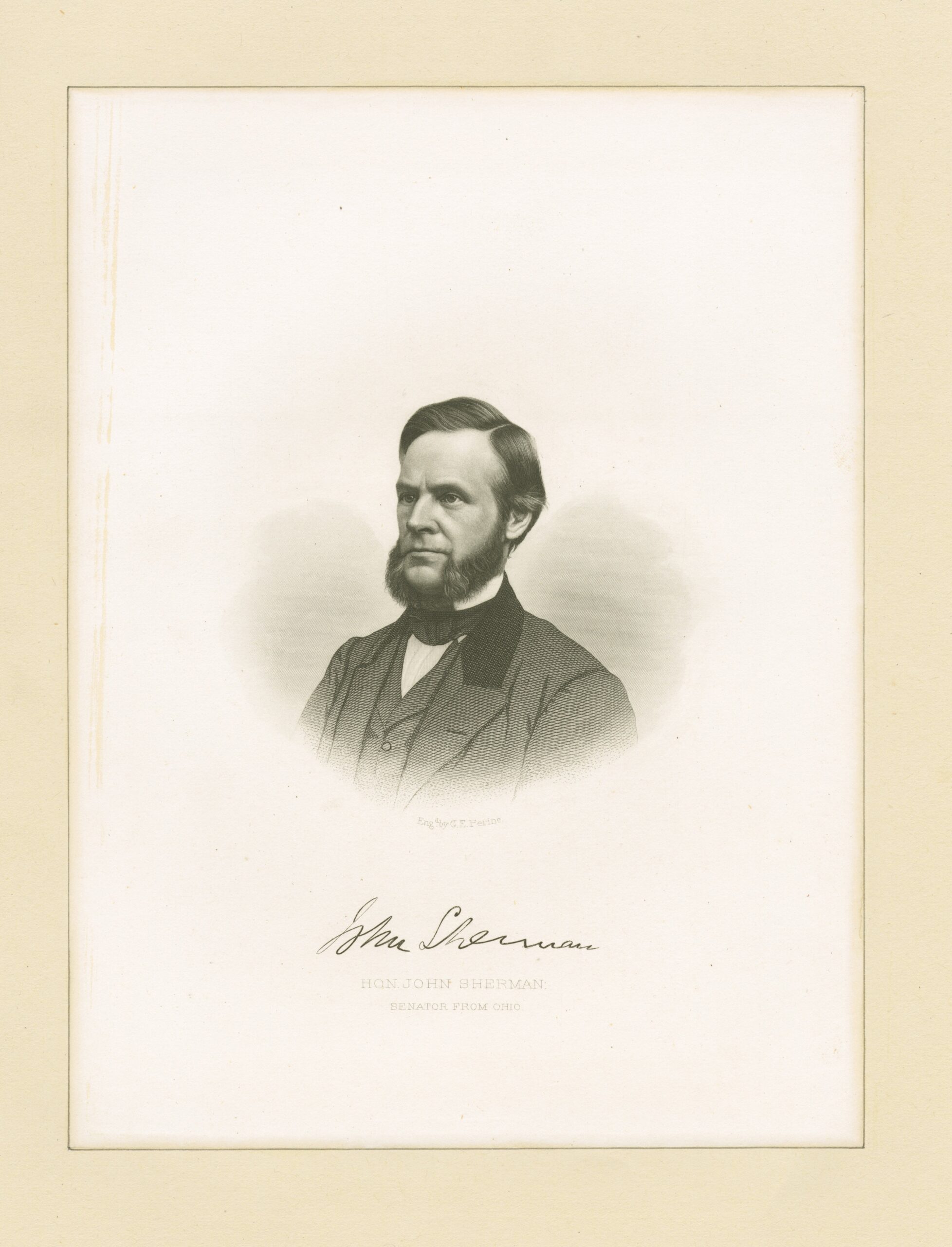
The neighborhood was platted that way deliberately. On November 1, 1881, U.S. Senator John Sherman of Ohio recorded the Plat of Columbia Heights covering the 120-acre Stone Farm that he and asphalt magnate Amzi L. Barber had bought together the year before.
Yes, that Sherman. Author of the Sherman Antitrust Act.
Sherman named the subdivision for Columbian College, the institution that would later become George Washington University. Its campus sat near the heart of the original tract.
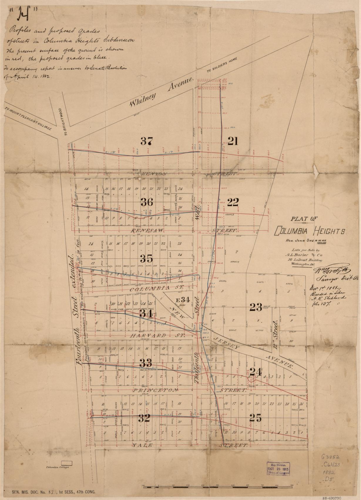
The street names were a deliberate signal. Yale, Harvard, Princeton, and Dartmouth advertised the cultural aspirations of the development. Kenesaw honored the Battle of Kennesaw Mountain in Senator Sherman’s brother William’s Atlanta Campaign.
Sheridan honored Phil Sheridan. Howard honored Oliver O. Howard, founder of the university a few blocks east. Lydecker honored Colonel Garrett Lydecker, the Army Engineer who served as Engineer Commissioner of DC from 1882 to 1886.
The names told you whose Washington this was supposed to be.
Sherman and Barber put up the land
Sherman provided the political and financial weight. Amzi L. Barber provided the engineering.
Barber was known nationally as the “King of Asphalt” because his Barber Asphalt Paving Company controlled the bulk of the asphalt market in late-nineteenth-century American cities, including Washington’s own pavements. He had the capital, the infrastructure connections, and a long-running interest in upper Northwest real estate.
Their partnership platted the subdivision, then sold lots into a market that boomed once electric streetcar service reached the heights in the early 1890s. You can see the neighborhood in transition on this 1887 map of Mt. Pleasant and Columbia Heights.
By the time the renaming fight began, the neighborhood had several thousand residents and a citizens association with a real political voice.
The 1893 Highway Act and a decade of waiting
The Permanent Highway Act of March 2, 1893 extended the L’Enfant grid system into Washington’s unregulated suburban subdivisions. In principle, that put Columbia Heights on track for renaming the moment the District Commissioners chose to act, fitting it into the city’s broader alphabetical and numbered street system.
In practice, nothing happened for eleven years.
That changed in May 1904, when Congress passed authorizing legislation specifically empowering the Commissioners to rename the streets in the Columbia Heights suburbs under the existing nomenclature system. The Commissioners had the legal trigger, but they did not yet have a finished schedule.
The citizens push back
The Columbia Heights Citizens Association was furious before the schedule was even drafted.
The College Streets were the neighborhood’s branding. Kenesaw was the most prominent address. Whitney Avenue was a marker of association with the Cleveland-era political class.
The clearest surviving voice from the protest is Judge McCalmont, speaking against the proposed Kenesaw-to-Irving change at a citizens meeting reported by the Washington Post on May 4, 1904:
Judge McCalmont led the opposition to the resolution. “This thing of having mathematical accuracy to everything I do not believe in,” he said, with considerable emphasis. “The scheme of naming these streets Yale, Harvard, and Princeton was a good one. They are significant of nice schools, names of colleges held in affection, and why should they not remain? I believe that the people should have something to say in the naming of their streets. Our people know enough to find the way home.”
McCalmont held up for ridicule the A-B-C system and what he saw as the lack of sentimentality in the proposed names.
The argument did not carry. The Commissioners had the statutory authority, the engineering staff had the schedule in progress, and the alphabetical sequence was already being extended across the rest of the suburbs.
The August 1905 announcement
The first comprehensive schedule landed on August 2, 1905. The Washington Post published the full list of pending changes covering the section of the city bounded by Rock Creek Park and the Zoological Park on the west and North Capitol Street on the east.
The numbered streets extended northward to the District line. The lettered streets, as far as the end of the alphabet, were extended into the District outside of the old city limits of Florida Avenue. Then came two-syllable names alphabetically arranged, and then three-syllable names.
For Columbia Heights proper, the August list called for:
| Original name | August 1905 rename |
|---|---|
| Clifton Street | Douglas Street |
| Roanoke Street | Euclid Street |
| Yale Street | Franklin Street |
| Princeton Street | Girard Street |
| Harvard Street | not changed |
| Columbia Street | Columbia Road |
| Kenesaw Street | Irving Street |
| Kenyon Street | not changed |
| Dartmouth Street | Lawrence Street |
| Whitney Avenue | Marshall Road |
Wait, you are not recognizing half of these new names, are you? That is the point. Columbia Heights was only one of a dozen subdivisions getting reorganized at the same time, and the Post ran the whole sprawling schedule. Here it is in full:
A revolution in the names of streets in the section of Washington bounded generally by Rock Creek Park and the Zoological park on the west and North Capitol street on the east is shown by many new names which were announced yesterday by the Commissioners. The numbered streets extend northward to the District line and the lettered streets, as far as the end of the alphabet, are extended into the District outside of the old city limits of Florida avenue. Until the alphabet is exhausted names of two syllables, alphabetically arranged, are given, and then names of three syllables are selected.
Columbian College Grounds, north part—Bacon street changes to Harvard street, and Binney street changed to Girard street.
Columbian College grounds, south part—Chapin street unchanged, and Staughton street changed to Buford street.
Columbia heights—Clifton street changed to Douglas street, Roanoke street changed to Euclid street, Yale street changed to Franklin street, Princeton street changed to Girard street, Harvard street not changed, Columbia street changed to Columbia road, Kenesaw street changed to Irving street, Kenyon street not changed, Dartmouth street changed to Lawrence street, and Whitney avenue changed to Marshall road.
Denison & Leighton’s subdivision—Kenesaw avenue changed to Irving street, and Grant street changed to Lawrence street.
Gass subdivision—Whitney avenue changed to Marshall road, and Scott avenue changed to Newton place.
Haw’s subdivision—Grant avenue changed to Barry place.
Howard University subdivision—Wilson street changed to V street, Pomeroy street changed to W street, Trumbull street, east of Fourth, changed to Bryant street; Howard avenue changed to Howard place, Lincoln street changed to Franklin street, Sumner street changed to Girard street, Colfax street changed to Gresham place, and Morris street changed to Hobart place.
Holmead Manor—Rock Creek Church road changed to Marshall road, Lydecker avenue changed to Monroe street, Holmead avenue changed to Holmead place, Eslin avenue changed to Eleventh street, Morgan avenue changed to Tenth street, and Lamar place changed to Otis place.
The August list did not stick.
The October 1905 revision
Three months later the Engineer Commissioner went back over his own work. Col. John Biddle, who served as Engineer Commissioner from 1901 to 1907, submitted a revised schedule to his colleagues on the District Board, which adopted it that Wednesday with six names held under consideration until the following day.
The Washington Post published Biddle’s final version on October 15, 1905.
For Columbia Heights proper, the October revision changed several of the August names:
| Original name | August 1905 (initial) | October 1905 (final) |
|---|---|---|
| Clifton Street | Douglas Street | retained as Clifton |
| Roanoke Street | Euclid Street | Euclid Street |
| Yale Street | Franklin Street | Fairmount Street |
| Princeton Street | Girard Street | Girard Street |
| Harvard Street | not changed | not changed |
| Columbia Street | Columbia Road | Columbia Road |
| Kenesaw Street | Irving Street | Irving Street |
| Kenyon Street | not changed | not changed |
| Dartmouth Street | Lawrence Street | Lamont Street |
| Whitney Avenue | Marshall Road | Park Road |
The systemic schedule Biddle handed in is worth reading at length. The Post ran it on October 15, 1905:
Col. John Biddle, the Engineer Commissioner, submitted to his colleagues of the District board yesterday the completed schedule of changes in the names of streets in the suburban territory north and northwest of Florida avenue. The schedule was practically adopted by the board last Wednesday, six names being held under consideration until yesterday. The list of streets and names follows:
Columbian College Grounds (North part)—Bacon to Harvard, Binney to Girard.
Columbian College Grounds (South part)—Chapin unchanged, Staughton to Belmont.
Columbia Heights—Roanoke to Euclid, Yale to Fairmount [sic], Princeton to Girard, Harvard not changed, Columbia street to Columbia road, Kenesaw to Irving, Kenyon not changed, Dartmouth to Lamont, Whitney avenue to Park road.
Denison and Leighton’s subdivision—Kenesaw avenue to Irving street, Grant to Lamont.
Gass subdivision—Whitney avenue to Park road, Scott avenue to Newton place.
Halls’ subdivision—Eighth to Ninth.
Haw’s subdivision—Grant avenue to Barry place.
Howard University subdivision—Wilson to V, Pomery to W, Trumbull, east of Fourth, to Bryant; Trumbull, west of Sixth, not changed; Howard avenue to Howard place, Lincoln to Fairmount, Sumner to Girard, Colfax street to Gresham place, Morris street to Hobart place.
Holmead Manor—Rock Creek Church road not changed, Lydecker avenue to Monroe street, Holmead avenue to Holmead place, Eslin avenue to Eleventh street, Morgan avenue to Tenth street, Lamar place to Otis place.
Three streets changed names twice in three months. Yale was Yale, then briefly Franklin, then settled as Fairmount (later spelled Fairmount and then Fairmont on the modern map). Dartmouth was Dartmouth, then briefly Lawrence, then Lamont. Whitney was Whitney, then briefly Marshall, then finally Park Road.
This sounds like a horribly chaotic process for naming the streets. I can imagine sitting in the meeting where two men are fighting over calling Dartmouth Street Lawrence or Lamont Street. Does it matter in the long run? No. But if the guy’s name was Lawrence, he is probably still pissed.
The Holmead Manor section and adjoining subdivisions saw their own renamings in the October schedule. Lydecker Avenue to Monroe Street. Holmead Avenue to Holmead Place. Eslin Avenue to Eleventh Street. Morgan Avenue to Tenth Street. Lamar Place to Otis Place. Rock Creek Church Road kept its name.
The Tillman Joy complaint, twenty-four years later
The renaming did not satisfy everyone, and the irritation lingered.
On Christmas Day 1929, a Columbia Heights resident named Tillman Joy wrote a letter to the Washington Post complaining that the systematic plan had been undermined by sentimentality and exception:
Quite a number of years ago the authorities adopted a scheme for the systematic naming of streets added to those already regularly lettered, numbered and otherwise named. Naturally, it was thought that in its future growth the city would be free from the antiquated, unsystematic arrangement with which it was threatened. But it was not to be. At least, it was not to be, so far as Columbia Heights, where I reside, is concerned. For some reason, or no reason, old local names were retained, and in the case of new streets names were fixed according to the sentimental wishes of individuals or the whim of the street-naming expert.
Joy went on to list the survivors. Brown, Center, Oak, and Pine Streets. Hiatt Place, Meridian Place, Mozart Place, Ingleside Terrace.
And the duplications. Spring Road, Spring Place, Park Road, Park Place, Parkwood Place. All within one neighborhood.
The duplications survived him.
Why this matters for the map you read today
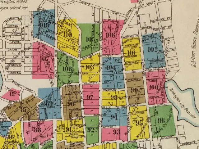
The 1903 Baist Real Estate Atlas captures the neighborhood two years before the renaming. The lot lines, block widths, and most of the alleys match the modern map. What changed is what the streets are called. There is also a related 1885 map of north Columbia Heights that shows the subdivision in its earliest commercial form.
The Kenesaw Apartments at 16th and Irving kept the old name on its façade after the avenue underneath had been renamed. That building is the most visible ghost of the original plat.
The Columbia Heights pattern is the same one that turned B Street into Constitution Avenue: a systematic plan, applied unevenly, with the survivors carrying the memory of what was changed. The Columbia Heights Heritage Trail, nineteen markers beginning at 14th and Irving, surfaces some of this history at street level. Bring an 1894 map if you want to feel the disorientation properly.
I used to live on Clifton Street and always wondered why it wasn’t something like “Davis” since it is between Chapin and Euclid. Now I know it was supposed to be Douglas (I assume named after Frederick) but no reasoning given as to how it stayed Clifton.
Funny in the old Statutes at Large I ran across something July 2, 1864 (355) about making Colfax a street. It said: “that from and after the passage herof, the alley, which is sixty feet wide, across square seven hundred and twelve, and which connects L and M streets north, and west line of which is two hundred and twelve feet east of the east line of First street, shall be known as Colfax street”
Section two said “that congress may hereafter, at any time, amend or repeal this act”
Staughton, Chapin, Binney – former presidents of Columbian College, now George Washington U.