Skip to content
Ghosts of DC

Ghosts of DC

  • The Best Of
  • Neighborhoods
    • Southwest DC
      • Waterfront
    • Maryland
      • Gaithersburg
      • Rockville
      • Bethesda
      • Hyattsville
      • Silver Spring
      • Bladensburg
    • Virginia
      • McLean
      • Falls Church
      • Alexandria
      • Vienna
      • Arlington
    • Southeast DC
      • Congress Heights
      • Navy Yard
      • Capitol Hill
      • Anacostia
    • Northeast DC
      • Trinidad
      • Woodridge
      • Deanwood
      • Brookland
    • Northwest DC
      • Tenleytown
      • Park View
      • Friendship Heights
      • Brightwood
      • Crestwood
      • Sheridan-Kalorama
      • The Palisades
      • Logan Circle
      • Petworth
      • Glover Park
      • Bloomingdale
      • Georgetown
      • Woodley Park
      • Dupont Circle
      • Columbia Heights
      • Cleveland Park
      • Adams Morgan
      • Mt. Pleasant
      • Chevy Chase
      • Cathedral Heights
      • Chinatown
    • Lost Neighborhoods
      • Hell’s Bottom
      • Swampoodle
      • Murder Bay
  • Notable People & Places
    • Places
      • Washington Monument
      • Library of Congress
      • The White House
      • The Capitol Building
      • Dulles Airport
    • People
      • Franklin D. Roosevelt
      • Calvin Coolidge
      • Officer Sprinkle
      • Dwight D. Eisenhower
      • Warren G. Harding
      • William McKinley
      • Abraham Lincoln
      • John F. Kennedy
      • Teddy Roosevelt
      • Woodrow Wilson

Waterfront

Aerial Views of the Washington Navy Yard Before, During, and After President Kennedy’s Assassination

November 9, 2022September 9, 2015 by ghostsofdc
Aerial view of the Washington Navy Yard, looking east (top). This shot shows the Navy Yard’s borders: M Street on the north (left); the waterfront on the south; 11th street on the east, and 2nd street on the west (foreground). On the right bank of the river is Anacostia, September 1963. NHHC Photograph Collection, Navy Subject Files, Washington Navy Yard. (214).

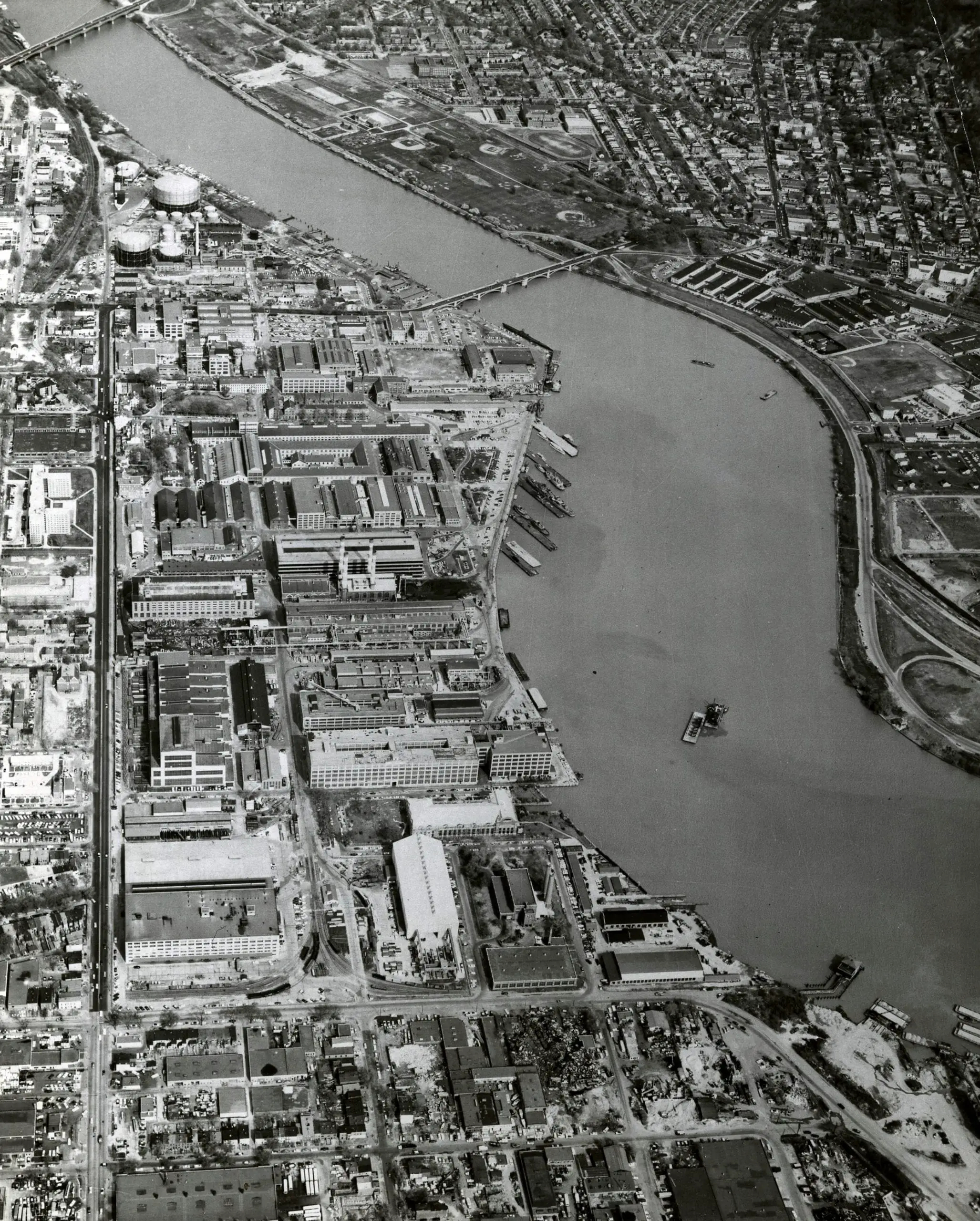
Take a look at the Washington Navy Yard before, during, and after President Kennedy’s assassination with these aerial views from the 1960s, 1970s, and 1980s.

Categories Faces & Places of Yesterday Tags 1960s, 1970s, 1980s, Anacostia, Navy Yard, Waterfront

A Glimpse Into Life in Southwest Washington Between 1900s and 1910s

February 16, 2022November 9, 2013 by ghostsofdc
southwest Washington

Take a look at a photo from southwest Washington between 1900s and 1910s, courtesy of Streets of Washington. Get a glimpse into the daily life of this time period and see how much has changed.

Categories Faces & Places of Yesterday Tags 1900s, Southwest, Waterfront 5 Comments

Herzog’s Seafood Restaurant: A Washington, D.C. Dining Legacy

October 13, 2023March 29, 2013 by ghostsofdc
waiter at Herzog's

Where was Herzog’s famous sea food restaurant in Washington, DC? And, what did it look like?

Categories Faces & Places of Yesterday, Lost History Tags 1940s, Potomac River, Waterfront

Celebrating our First Birthday with a Look at the Transformation of Washington’s Waterfront

December 20, 2021January 4, 2013 by ghostsofdc
1909 map of D.C. waterfront in southwest

Celebrate our first birthday by taking a look at how much the Washington waterfront has changed since 1909. See the ambitious development projects that are transforming the area and the map of the waterfront from 1909.

Categories GoDCers Love Maps Tags 1900s, Waterfront 1 Comment
© 2026 Ghosts of DC • Built with GeneratePress