
Picture this: a streetcar dipping below 14th Street and gliding under downtown Washington at 16 miles an hour while the gridlock crawls along up top. In the fall of 1944, with World War II still being fought, that was a real plan sitting on a real desk at the District Building. And had it been built, it would have been the longest streetcar subway in the entire country.
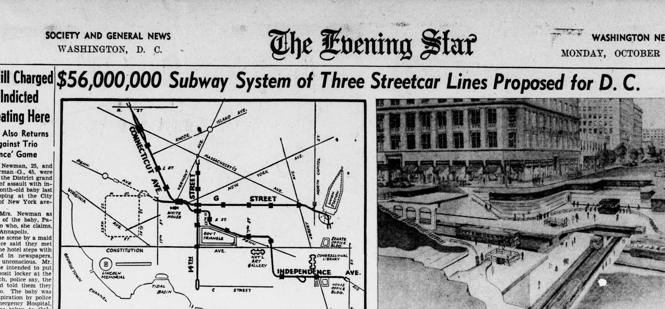
We dug up the front page of The Evening Star from Monday, October 23rd, 1944, and the banner across page B-1 says it all: “$56,000,000 Subway System of Three Streetcar Lines Proposed for D. C.” The price tag was actually a touch higher than the headline rounded it to, $56,400,000, which works out to the better part of a billion dollars in today’s money.
If this sounds familiar, that’s because the District had been flirting with the idea for decades. A downtown subway was floated all the way back in 1912 and went nowhere. The 1940s version was bigger, bolder, and came a lot closer than you might think.
A city bursting at the seams
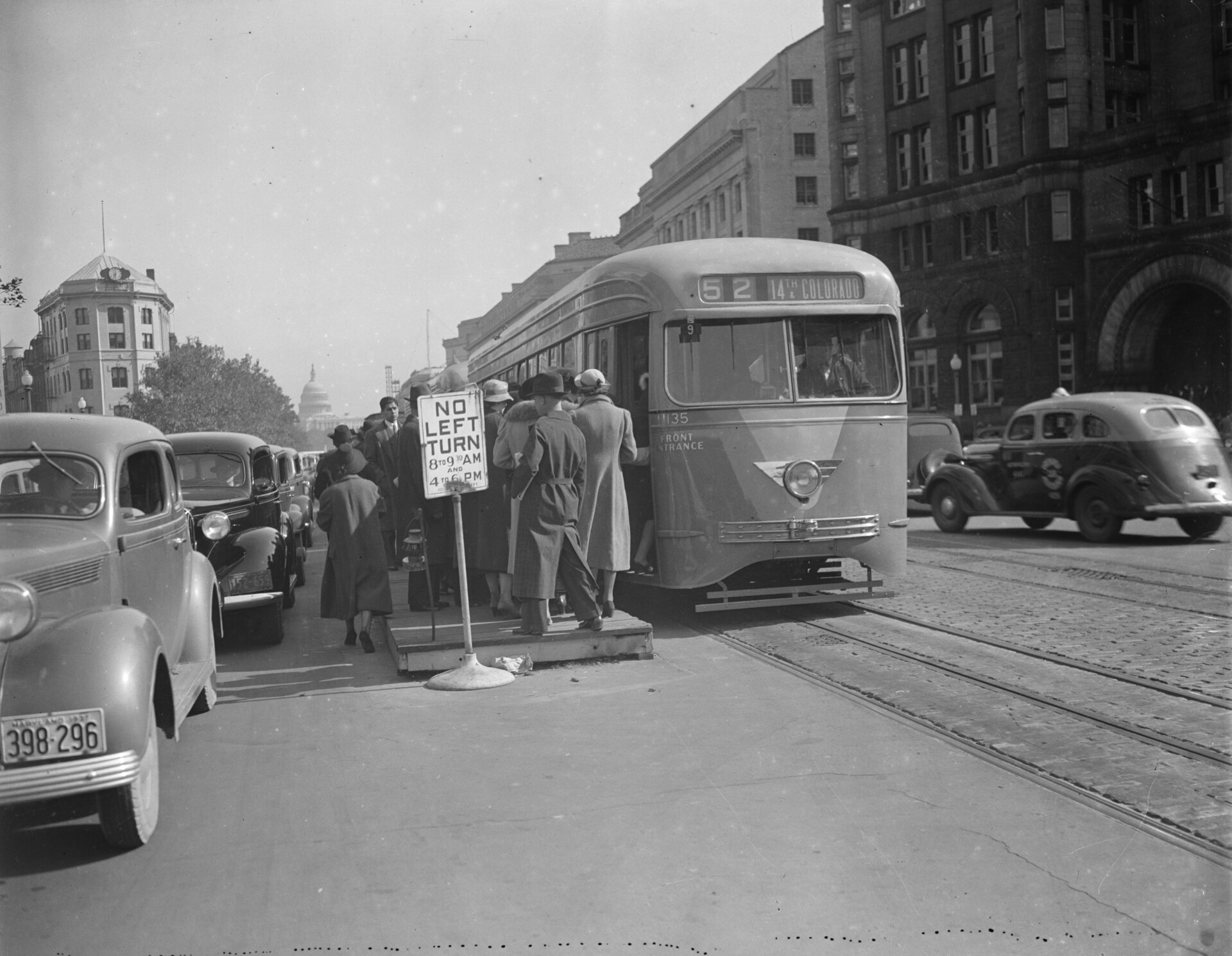
Between 1930 and 1950, Washington exploded. Roosevelt’s New Deal had ballooned the federal government after the Depression, and then the war called tens of thousands more workers to town to manage the bureaucracy of war. In just two decades the city’s population nearly doubled, from 486,000 to 802,000. (The Civil War did something similar, jumping the city from 75,000 to 132,000.) All those people needed to get to work, and the downtown streetcars were barely moving.
How slow? The engineers actually measured it. In the central business district, streetcars were averaging three to six miles per hour, hardly better than before the war, and private cars weren’t much quicker. Drop those streetcars into a tunnel, the consultants figured, and they would average 16 miles per hour, saving the typical rider 10 to 15 minutes on every trip.
The 1944 plan
The plan came from two consulting firms hired by the District government, the J. E. Greiner Company and De Leuw, Cather & Company. On October 23rd, 1944, the Commissioners released the engineers’ “master plan” to the public, in the words of the Star, “without recommendations but with a request for studied reactions from public and private groups.” Here is how the paper opened the story:
Construction of three street car subway systems costing about $56,400,000 was proposed today by consulting engineers of the District Government as the major element of a broad postwar traffic relief to speed travel in the city’s central area. Such a program, they contended, was necessary to prevent congestion from reaching “disastrous proportions” and to halt a decentralization trend which “threatens to explode the city.”
Read that last line again. In 1944 they were already terrified that Washington would “explode” into the suburbs if downtown stayed clogged. You know how that story ends. The decentralization they feared happened anyway, on a massive scale, and it is still happening today.

Three lines, 7.1 miles of tunnel
The heart of the plan was 7.1 miles of tunnel carrying three streetcar subways:
The three subways would be: Fourteenth street, from south of Thomas Circle to the underground car terminal near Maine avenue; Connecticut avenue-G street, running from Connecticut avenue and R street to Union Station, and a Pennsylvania avenue line, from Eighteenth street N.W. to Second street S.E.
If you ride Metro today, those routes will feel eerily familiar. As the transit writers at Greater Greater Washington have noted, the Connecticut Avenue and G Street line traces almost exactly what the Red Line does now between Dupont Circle and Union Station, and the Pennsylvania Avenue line foreshadows the Blue, Orange, and Silver lines between Farragut West and Capitol South. The 1944 engineers were quietly sketching the bones of Metro thirty years early.

And it would have set a record. In 1944, Boston had the longest streetcar subway in the country, about two and a half miles plus a one-mile branch. Philadelphia’s downtown streetcar tunnel was under a mile. Newark and Rochester had short ones threaded through old canal beds. Washington’s 7.1 miles would have dwarfed every one of them.
Who pays?
That was the catch, and the report dodged it. The cost, the consultants wrote, should be split “equitably” among everyone who benefited, and they pointed to the Federal Government as having the greatest interest of all. They were blunt about the stakes, voicing deep concern about preserving the high values of downtown real estate and keeping shops and shoppers from being driven out to the fringes, which would cost the District government a fortune in lost tax revenue.
So why didn’t it happen?
Mostly because nobody ever said yes. The Commissioners had asked for reactions, not approval, and the plan simply sat. A slimmed-down version surfaced in 1946 at about $34 million, with the fancier mezzanine stations stripped out, but it never found funding either.
There was a deeper problem, too. The whole scheme was built around streetcars, and Washington’s streetcars were living on borrowed time. After a bitter 1955 strike, the system was sold and reorganized as D.C. Transit, under explicit orders to convert to buses. Early on Sunday, January 28th, 1962, car 766 rolled into the Navy Yard car barn for the last time, ending nearly a century of trolley service in the capital. A streetcar subway with no streetcars to run in it was a non-starter.
The dream that became Metro
The idea didn’t die, though. It just kept changing shape. Back in 1912, the District Commissioners had pushed for a downtown subway with a grand terminal at 15th and Pennsylvania, and in 1918 Alabama Senator Joseph F. Johnston even introduced a bill to charter a Capital City Subway Company. Both efforts collapsed. We told that whole story over here.
The real turning point came in 1960, when Congress passed the National Capital Transportation Act and stood up a federal agency, the National Capital Transportation Agency, to finally crack the problem. Under administrator Darwin Stolzenbach, a Kennedy appointee, the agency pushed past the highway-first crowd and recommended a regional rail rapid transit network. President Johnson signed the rail plan into law on September 8th, 1965, the Washington Metropolitan Area Transit Authority was created in 1967, and on March 27th, 1976, the first Metro trains finally rolled, from Farragut North to Rhode Island Avenue on the Red Line.
That was 64 years after the 1912 proposal and 32 years after the engineers handed the Commissioners their $56 million blueprint. When the trains finally came, they ran in deep tunnels rather than shallow streetcar subways, and they carried sleek aluminum rail cars instead of trolleys. But the routes? Take one more look at that 1944 map. Washington had been drawing this thing for a very, very long time.
Anything you’ve always wondered about Metro’s near-misses and might-have-beens? Tell us in the comments.