Skip to content
The Best Of
Neighborhoods
Southwest DC
Waterfront
Maryland
Gaithersburg
Rockville
Bethesda
Hyattsville
Silver Spring
Bladensburg
Virginia
McLean
Falls Church
Alexandria
Vienna
Arlington
Southeast DC
Congress Heights
Navy Yard
Capitol Hill
Anacostia
Northeast DC
Trinidad
Woodridge
Deanwood
Brookland
Northwest DC
Tenleytown
Park View
Friendship Heights
Brightwood
Crestwood
Sheridan-Kalorama
The Palisades
Logan Circle
Petworth
Glover Park
Bloomingdale
Georgetown
Woodley Park
Dupont Circle
Columbia Heights
Cleveland Park
Adams Morgan
Mt. Pleasant
Chevy Chase
Cathedral Heights
Chinatown
Lost Neighborhoods
Hell’s Bottom
Swampoodle
Murder Bay
Notable People & Places
Places
Washington Monument
Library of Congress
The White House
The Capitol Building
Dulles Airport
People
Franklin D. Roosevelt
Calvin Coolidge
Officer Sprinkle
Dwight D. Eisenhower
Warren G. Harding
William McKinley
Abraham Lincoln
John F. Kennedy
Teddy Roosevelt
Woodrow Wilson
-ad 189-
Published
February 27, 2014
Exploring D.C. History Through a 1937 Map of Neighborhood Boundaries
Take a journey through D.C. history with this 1937 map of neighborhood boundaries. Learn more about the city's past and explore the changes that have taken place over the years.
Three Stories from the Corcoran Gallery's History
Revisiting History: A Look at the Cuban War Mission to the United States in 1917
No posts found
-ad 188-
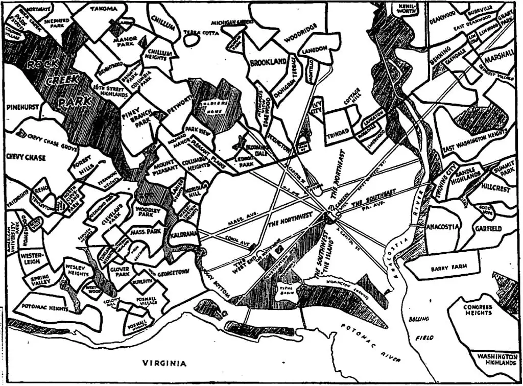
Here’s a great old map that we found showing all the neighborhood boundaries from
1937
.
1937
map of D.C.
-ad 617-
More For You
Exploring the Last Farm in the District: A Look at the 1921 Map of Bellevue Highlands
A Look at the Dupont Circle Building from the Air in the 1930s
No posts found
Back from Memorial Day: Little Girl Tries Roller Skating with Pillow Bumpers
The Near-Lynching of Tom Smothers in Washington, D.C. and Frederick Douglass' Role in Saving Him
No posts found
The 1933 Chesapeake and Potomac Hurricane: The Wreck of the Crescent Limited Train
Tragedy in the Snow: The Story of Little Betty Amberger and the 1939 D.C. Snowstorm
No posts found
A Rare Find from the Boston Public Library
1800 Plan of Washington and Capitol Hill Lots
No posts found
Electric Lights and the New Era of Progress: Remembering President Woodrow Wilson's Inauguration
Dulles Airport Opening Dedication Footage From 1962
Exploring an 1857 View of Washington, D.C. with the Smithsonian in the Distance
No posts found
-ad 615-
Why Is It Named Trinidad?
Who Were the Original Land Owners in Washington, DC?
1890s Map of Diarrhea Deaths in Washington
No posts found
-ad 616-
This Retro Metro Infomercial from the 1970s Is Amazing!
Where Washington's Historic Chain Bridge Gets Its Name
Fire and Explosions Threaten to Destroy Rosslyn
No posts found
-ad 630-
Popular Posts
1895 Bird's Eye View of Brookland
No posts found
Why Is It Named Ballston?
Shaw, Mt. Vernon Square, and Dupont Circle: A 19th-Century Property Value Comparison
A Trip Down Memory Lane - Exploring the "Lawyers' Row Block" in Arlington from the Early 1990s
A Rare Look at the Dupont Circle Metro Station - Vintage Photos of Washington, D.C.
No posts found
Enjoy daily
Ghosts of DC stories.
SUBSCRIBE
No thanks.
x