
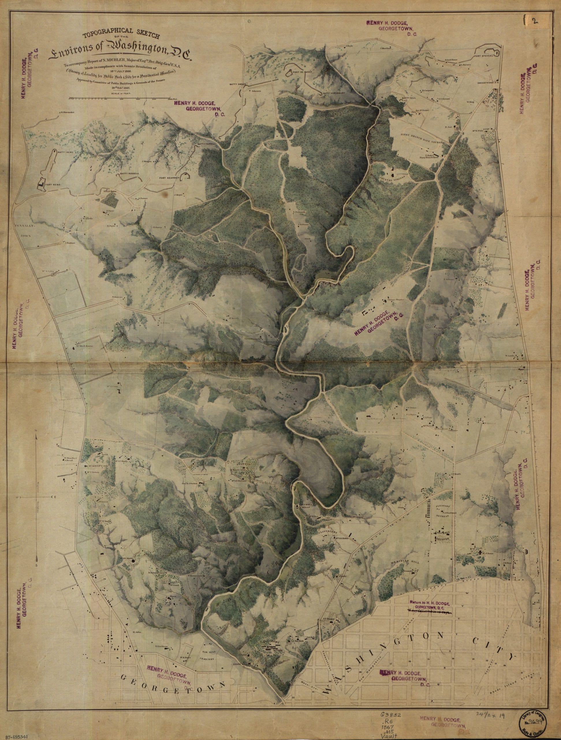
This is a beautiful topographical map of the area that would become Rock Creek Park. The map was done in 1866 in compliance with a Senate Resolution of July 18th, 1866.
This is a beautiful topographical map of the area that would become Rock Creek Park. The map was done in 1866 in compliance with a Senate Resolution of July 18th, 1866.
Comments are closed.
Looks like Taylor Lane Road became Columbia Road, presumably because it went just above Columbia College.
Actually it had been “Tayloe’s Lane” , leading to “Petworth” the country estate of Colonel John Tayloe whose city home was the Octagon House. He also was the creator of the race track near 14th St and Kenyon on land leased from the Holmead family which operated from early 1800’s to 1840 or so. Wonder if “Taylor” is a typo. You (GoDC) would make quite a coup if you could find that racetrack on a map!
It also shows clearly the Columbian College campus east of Meridian Hill, along 14th St. And that interesting grouping of houses along the western border of the campus. This was post war, so it does not show the Civil war hospitals or encampments. But there were settlements of “contrabands”(escaped slaves) associated with those uses left after the war. One of Boss Shepherd’s actions in the next decade was to clear those settlements , when real estate on the hills outside the original city of Washington was attracting interest–such as General WT Sherman’s brother John Sherman’s purchase of the Stone estate east of 14th which he named Columbia Heights.
And something else : when I finally got the zoom to work so the map could be read: look at the title: “…Location for a Public Park & Site for Presidential Mansion” . I could not locate any marking of where the mansion might have been proposed ..I know Sherman and Mary B.Henderson were lobbying for a White House on the hill.(no doubt on land they each owned).There was also a movement to relocate the entire capital of the US to the midwest/St.Louis? Actually, it was probably Boss Shepherd’s improvements to infrastructure that may have quashed that.
Anyone have any idea how I can make/get a poster of this!? Beautiful!
Would also be interested in getting a copy of this and framing it — ! love love love.
I get a 404 error when I click on the image.
I did a Google Images search and found it here…
http://cdn.ghostsofdc.org/wp-content/uploads/sites/7/2013/01/27162431/ct001303.jpg
Should be fixed now