
You’ve probably seen the headlines by now. The GSA just sold a 940,000-square-foot federal building at 301 7th Street SW for $24.26 million. Bloomberg is running features about how the Brutalist L’Enfant Plaza district “may not survive.” WTOP is calling the emerging neighborhood “Fedlandia.” Fifteen million square feet of underused federal office space, stretched between the National Mall and the waterfront, potentially up for grabs. The biggest redevelopment opportunity in Washington.
So we got curious. What was actually on this land before all those federal buildings went up? We went into the Evening Star archives at the Library of Congress and found some fascinating stuff.
A Neighborhood, Not a Wasteland
Before the concrete towers, before the underground shopping mall, before the Metro station, this patch of Southwest Washington was a neighborhood. A dense, complicated, very much alive neighborhood.
We’re talking Victorian row houses. Alley dwellings built in every gap between buildings, many without electricity or running water. There were corner groceries and churches, Black-owned businesses, a community of Black families and Eastern European Jewish immigrants, many of whom had been there since the Civil War. By the early 1950s, roughly 23,000 people lived in the area that would become L’Enfant Plaza and its surroundings.
The conditions were rough in places, with no indoor plumbing in many of the alley dwellings and overcrowding in buildings never designed for that many people. But this was a neighborhood that worked. Neighbors lent each other money and food. Children played in the streets. Residents recalled that people “stuck together.” If you’ve ever looked at our old photos of Southwest in the 1930s and 1940s, you’ve seen some of these streets. They were poor, but they were full of people.
Then came the outsiders’ view.
“Clear the Slums”
The groundwork had been laid years earlier. Back in 1945, Congress passed the District of Columbia Redevelopment Act, creating the Redevelopment Land Agency and handing it the power of eminent domain: the legal authority to seize private property for public use. By June 5th, 1949, senators were pushing Congress for immediate funds to get the program moving. The Evening Star reported that the RLA “has been starved to death financially.”
By the end of 1952, the first official urban renewal plan for Southwest, designated “Area B,” had been approved. In late 1953, the RLA began acquiring property. Residents were given $200 for moving costs and promises of affordable replacement housing. A displaced grocery store owner named Ezekiah Cunningham put it this way in 1954: “Well, it seems like they’re handin’ out a passel o’ joy and a passel o’ sorrow.”
Not everyone went quietly. A department store owner named Max Morris, whose store sat in the renewal zone but wasn’t blighted at all, sued. He argued the government couldn’t take his perfectly functional property just because the neighborhood around it had been declared a slum. The case went all the way to the Supreme Court. In November 1954, the justices ruled against him, 8 to 0. The decision in Berman v. Parker gave the government sweeping authority to condemn entire neighborhoods for redevelopment. It’s still cited in eminent domain cases today.
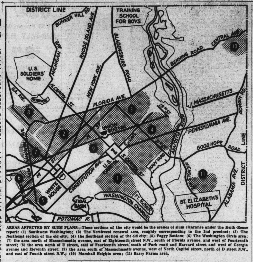
By January 14th, 1955, the Keith-Rouse report had mapped 11 sections of the city for “slum clearance or renewal projects.” Southwest Washington was Zone #1. The Evening Star published the map. It’s one of those images that stops you cold: a newspaper calmly numbering 11 neighborhoods for demolition, and the neighborhood where 23,000 people lived is at the top of the list. (If this reminds you of what happened to Murder Bay a generation earlier, you’re not wrong.)
And here’s one of the Gordon Parks photographs from the Library of Congress FSA-OWI Collection, showing daily life in the Southwest alley dwellings. These are the people and places that were about to be erased.
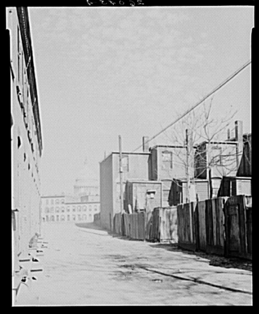
You can also browse the full HABS/HAER photo set of the Southwest Washington Urban Renewal Area at the Library of Congress for more images of what the neighborhood looked like before demolition.
The Demolition, by the Numbers
Here’s what happened next. Beginning in the spring of 1954, demolition crews leveled 4,800 structures across 560 acres. Some 23,000 residents were displaced, including 4,500 Black families relocated mainly to Northeast and Southeast DC, often with only a fraction of their homes’ value in compensation. Roughly 1,500 businesses closed. By the time it was over, ninety-nine percent of the buildings in Southwest had been demolished.
Critics called it the “Negro Removal Program.” A 1966 study on outcomes for the displaced residents found that a quarter of the people who were moved never made a single friend in their new neighborhood. They’d lost not just their houses but the entire social fabric that held their lives together.
On April 23rd, 1954, the Evening Star ran an editorial defending the plans, praising what it called a “sweeping face lifting in the blighted water-front area.” The language tells you everything about how the people who lived there were being thought of: blight to be cleared, not neighbors to be consulted.
For more on what the demolition looked like as it unfolded, here’s the Evening Star’s coverage from September 1st, 1955. And Boundary Stones has an excellent deep dive into the full cost of urban renewal in Southwest DC. The Smithsonian and Docomomo US have also documented the displacement extensively.
Zeckendorf’s $70 Million Dream
So a neighborhood of 23,000 people was bulldozed. What was the grand vision that was supposed to justify all that destruction?
This is where the story gets wild.
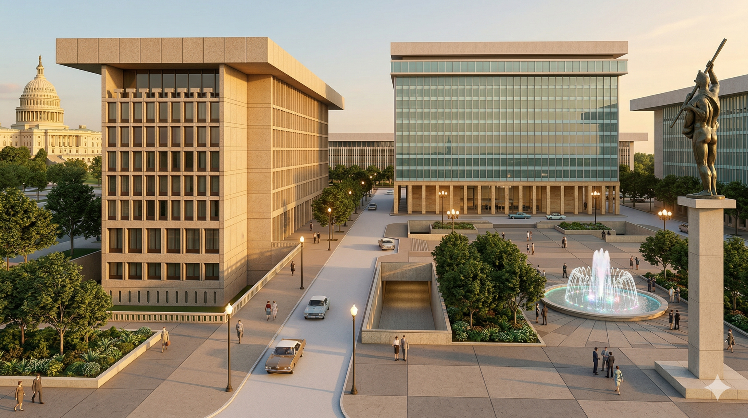
In February 1954, a New York developer named William Zeckendorf proposed a 20-acre cultural center on the cleared land. He called it “L’Enfant Plaza.” The plan included a concert hall, an opera house, outdoor restaurants, and a 400-foot-wide, grass-lined pedestrian promenade connecting to the Potomac waterfront. He hired I.M. Pei as master planner.
The Evening Star covered it like a moon landing.
On October 27th, 1961, the front page reported that Zeckendorf and the Redevelopment Land Agency had agreed on a price of $23.42 per square foot for a 99-year lease on almost 7 acres of “choice L’Enfant Plaza land.” That was over $20 more per square foot than he’d paid for 14 acres of nearby Southwest land just 17 months earlier. The total fee: $7 million, at $420,000 per year at 6%. The plan included a 1,000-room hotel and a 2,200-car underground garage. The cost of the Tenth Street Mall and garage alone: $12 million.
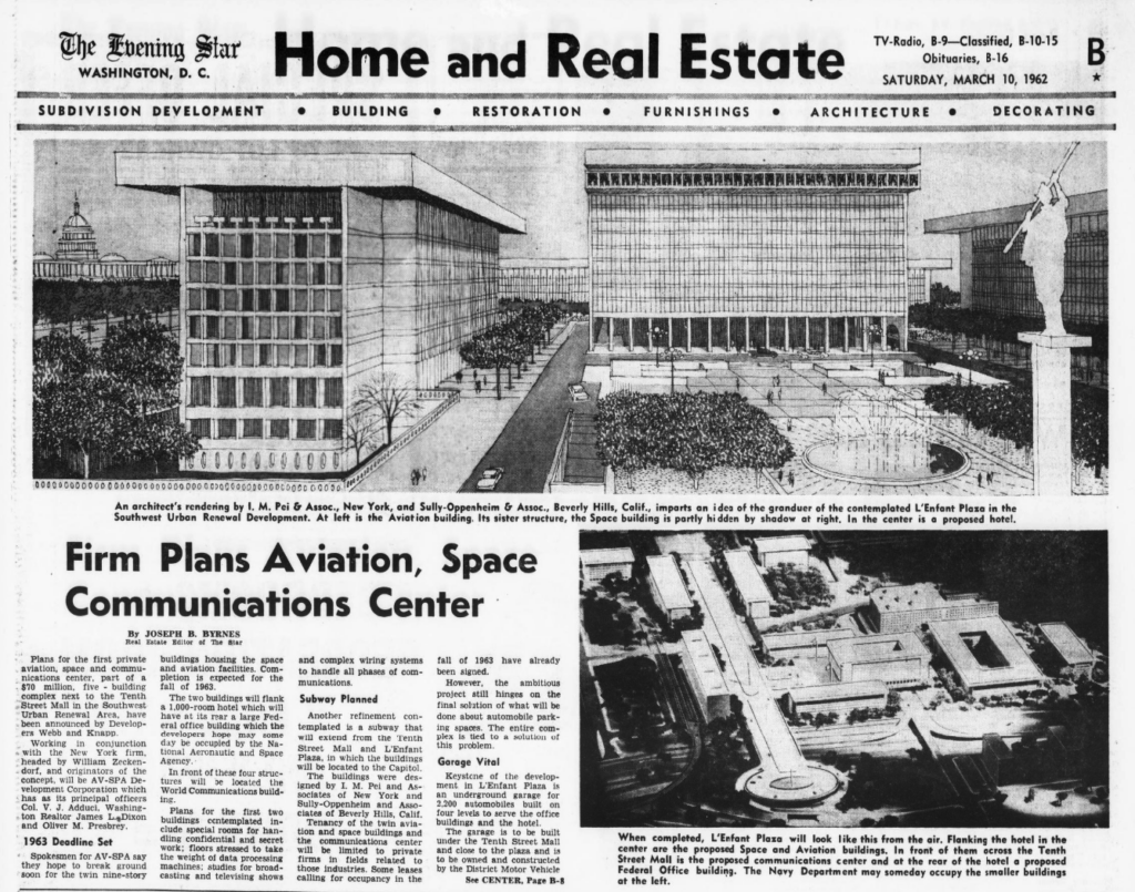
Then on March 10th, 1962, the Star ran a story with an I.M. Pei architectural rendering showing the dream version of L’Enfant Plaza. The headline announced:
“Plans for the first private aviation, space and communications center, part of a $70 million, five building complex next to the Tenth Street Mall in the Southwest Urban Renewal Area, have been announced by Developers Webb and Knapp.”
Compare the renderings to what’s there. What do you think?
You Know How This Story Ends
The concert hall and opera house? Never built. Washington’s performing arts center ended up in Foggy Bottom instead, as the Kennedy Center. The eight planned office buildings got shrunk to three. The outdoor restaurants from the Pei renderings, the 400-foot promenade to the Potomac, none of it was ever built.
And then the whole thing fell apart. Zeckendorf’s real estate empire collapsed. His company, Webb & Knapp, went bankrupt in 1965, right in the middle of construction, and he had to sell his interest in the project.
What got built instead were the stark Brutalist office towers designed by Pei’s partner Araldo Cossutta. Three slabs of raw concrete and glass where the renderings had shown a graceful complex of eight buildings, outdoor dining, and a promenade wide enough to rival the Champs-Elysees. The Tenth Street Mall, renamed L’Enfant Promenade, was supposed to be a tree-lined pedestrian boulevard connecting the Mall to the waterfront. Instead it became a windswept stretch of broken brick pavers and dying landscaping, flanked by concrete walls.
When L’Enfant Plaza finally opened to the public in June 1968, the Washington Post called it “a triumph of good architecture over bad planning.” That might be the most Washington sentence ever written.
Others were less generous. Architecture critics have described L’Enfant Plaza as “a dead zone, an overscaled void where you expect to see tumbleweeds blowing through at night or on weekends.” Greater Greater Washington, writing when Pei turned 100, called his DC buildings “notorious.” Washington City Paper described the whole area as “D.C.’s biggest urban planning disaster.” Fast Company traced how DC became a Brutalist playground, and L’Enfant Plaza is Exhibit A.
If you’ve walked through the plaza on a weekend, you know what they mean. It’s quiet in a way that doesn’t feel peaceful, just empty.
And Now?
Which brings us back to “Fedlandia.”
The GSA sold the building at 301 7th Street SW to D.C.-based Dalian Development for $24.26 million, the Liberty Loan Building is already under contract, and the Forrestal Building may be next. All told, fifteen million square feet of federal space sits between the National Mall and the waterfront, 87% of it underused. The National Capital Planning Commission is studying the whole area for redevelopment.
The early proposals are ambitious. One vision calls for demolishing the Brutalist structures, capping a section of the freeway, and extending the National Mall south to the waterfront. The numbers being floated include 2.4 million square feet of residential space, 800,000 square feet of museum and cultural space, and 200,000 square feet of hotel. What nobody has answered yet is whether any of the housing would be affordable, especially on land with Metro access and a view of the Washington Monument.
Nobody is being displaced from their homes this time. These are office buildings, not alley dwellings. But this is the third time in 70 years that someone has stood on this piece of ground and drawn up plans for what comes next. The first vision was a cultural center with opera houses and promenades. It went bankrupt. The second was a bureaucratic campus of concrete towers. It’s being sold off. The third is just getting started.
If your family lived in Southwest Washington before the bulldozers came in 1954, we’d love to hear from you.
