
The Inaugural Ride That Started It
January 20, 1961. The motorcade crawled down Pennsylvania Avenue toward the Capitol. Kennedy in the back of a limousine, waving to crowds that had dug out from eight inches of snow the night before.
Writing for Architectural Forum three years later, Douglas Haskell described what Kennedy saw from his seat. The slum-pocked north side of America’s main ceremonial street was, even over the bands and the cheers, “shockingly apparent.” A later PBS account adds the quote Kennedy reportedly gave Arthur Goldberg, who was about to be sworn in as Labor Secretary the next day and was riding in the same procession: “It’s a disgrace. Fix it.”
The north side of Pennsylvania Avenue in 1961 was empty lots, abandoned buildings, liquor stores, and peepshows. The south side was the monumental Federal Triangle. Between them ran the route of every American inaugural parade since Jefferson.
Goldberg took the complaint seriously. Unlike Kennedy, he came back and actually did something about it.
Moynihan Writes the Future
On August 4, 1961, at a cabinet meeting, Kennedy established the Ad Hoc Committee on Federal Office Space. Goldberg co-chaired. The actual work fell to Goldberg’s 34-year-old Special Assistant, Daniel Patrick Moynihan.
Moynihan spent the better part of a year on it. On June 1, 1962, he delivered “Report to the President by the Ad Hoc Committee on Federal Office Space.” He wrote two sections that would quietly reshape American cities: “Guiding Principles of Federal Architecture” and “The Redevelopment of Pennsylvania Avenue.”
The key line was Moynihan’s: “We must do something about the north side of Pennsylvania Avenue.”
Kennedy responded by creating the President’s Council on Pennsylvania Avenue. He appointed Nathaniel A. Owings, founding partner of Skidmore, Owings & Merrill, as chairman. The rest of the roster was mid-century American planning royalty. Chloethiel Woodard Smith. Dan Kiley. Paul Thiry. Ralph Walker. Douglas Haskell, the editor of Architectural Forum, who ran the committee’s report. Frederick Gutheim, Frederick Holborn, William Walton, and Moynihan himself.
They worked for more than a year in what was later described as “closely guarded, top-level” secrecy.
The 1964 Plan
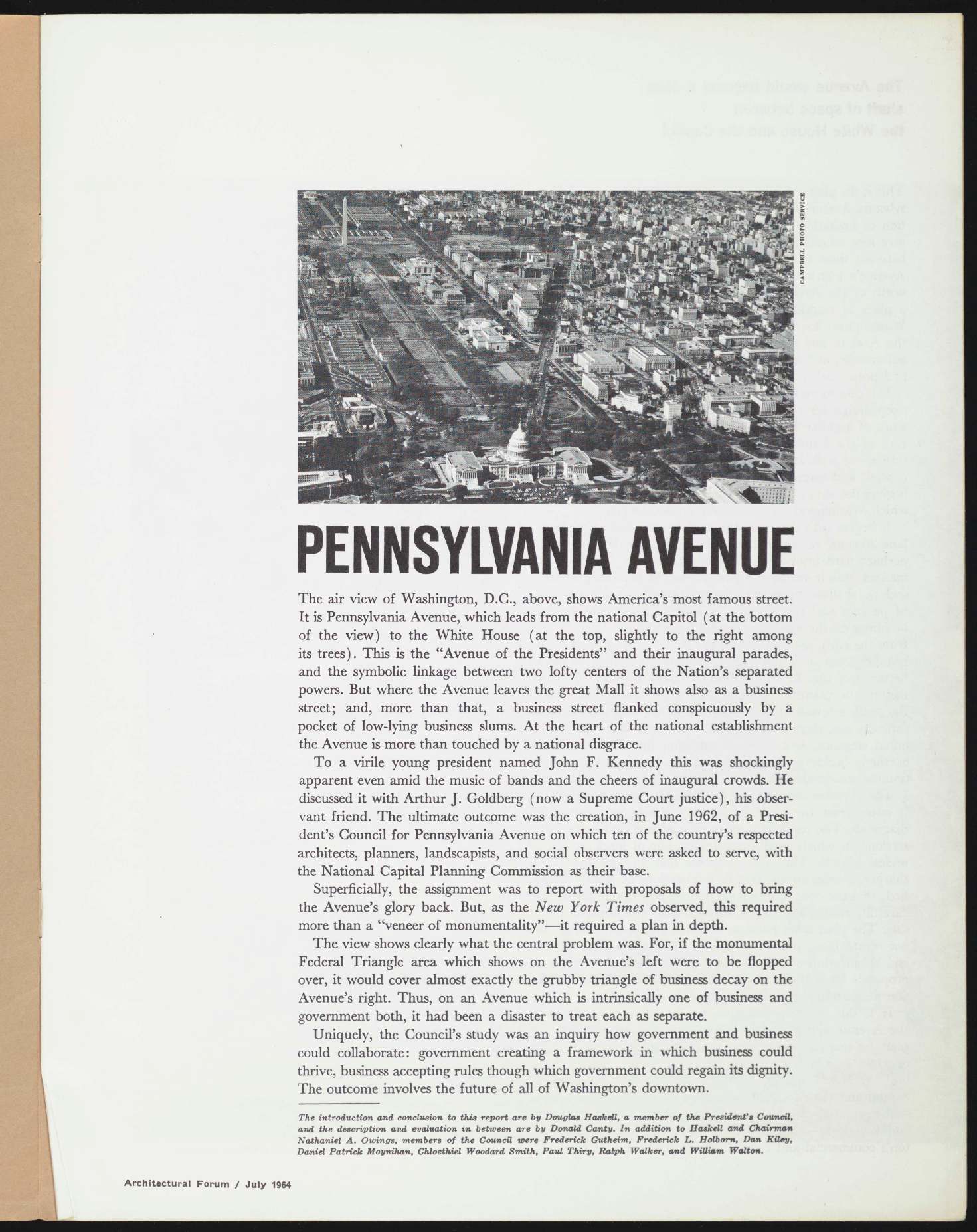
April 1964: the plan was unveiled. July 1964: the renderings and the full text ran in Architectural Forum. August 1 through September 13, 1964: the Museum of Modern Art in New York exhibited the physical model.
The model alone was worth the trip. Theodore Conrad, the Jersey City modelmaker whose work on Lever House and the Seagram Building had anchored a decade of mid-century landmarks, built a scale model of the entire redesigned avenue and the new northern quadrant. MoMA put it in a gallery with the Solovioff renderings on the walls.
What did the plan actually propose?
Start with the pavement. The Council wanted Pennsylvania Avenue repaved. Eight moving lanes. A permanent granite median. And the surface itself, in the Council’s words, “rich but subdued,” perhaps hard brick laid over concrete.
One architect on the team told the Post the brick “will not only look different but sound different” to motorists.
The sidewalks were supposed to become “graduated shelves, shallow three-level grandstands” for parade-watching. The buildings on the north side would be held back 75 to 80 feet from the curb. Five feet of the south sidewalk would be taken from cars and given back to pedestrians. Three rows of formally trimmed trees on the north side. Two rows on the south.
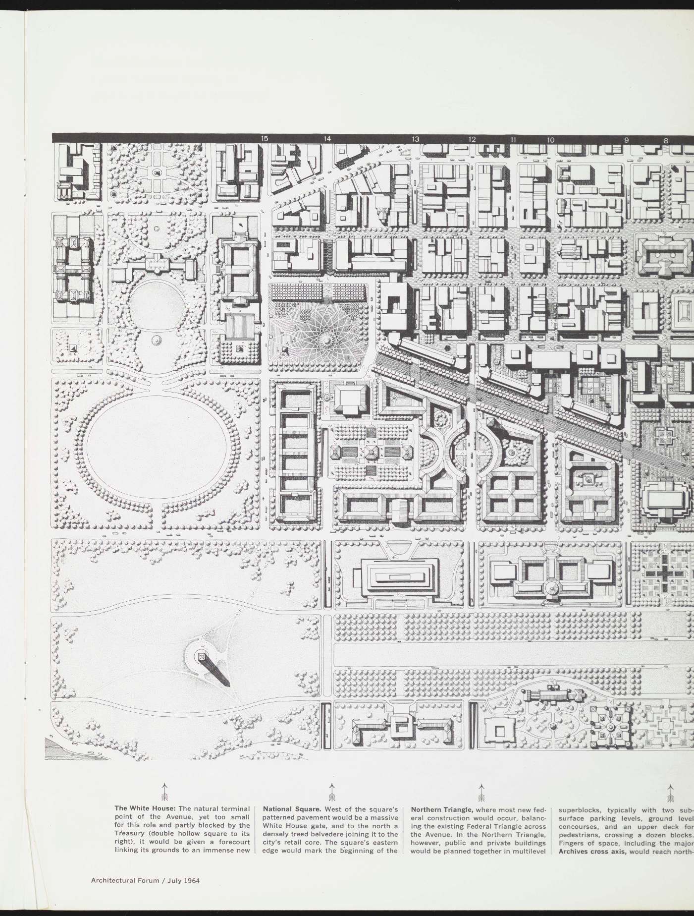
Then the tunnels.
Ten of them, buried beneath the new northern quadrant. The most dramatic was E Street, which the Post described on May 31, 1964:
The Keystone of the plan is the designation of E st. as the principal east-west route through the heart of downtown. Between 6th and 13th sts., E st. would be simply a “depressed street,” a road sunk beneath ground level and roofed over at intersections, but mostly open to direct sunlight. At 13th, however, it would become a tunnel, dipping under the proposed National Square and continuing beneath the southern fringe of the White House grounds, emerging at a point just west of 17th st.
Underneath all of this: 10,000 parking spaces.
The plan assumed you would drive to downtown Washington, disappear underground into one of ten portals, park in one of the 10,000 spaces, and emerge on foot into a reorganized civic landscape. Above ground, pedestrians, arcades, belvederes, and trees. Below ground, the automobile, out of sight.
National Square
The boldest piece of the plan was at the western end of the avenue.
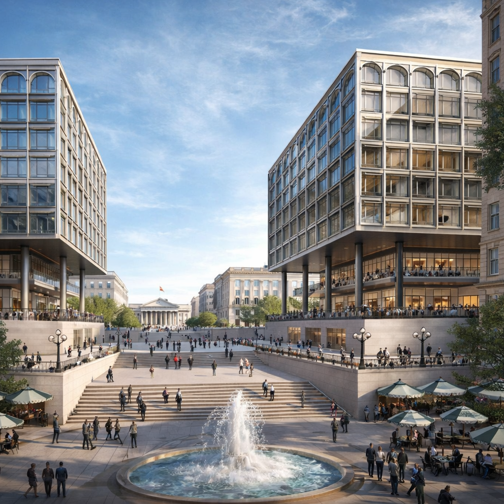
If you walk from the Willard Hotel to the Treasury today, you cross an open plaza paved in black granite and white marble. It’s called Freedom Plaza now. Originally Western Plaza. It’s about 200 feet wide.
The 1964 plan would have put, on the same ground, a ceremonial square eight hundred by nine hundred feet.
They called it National Square.
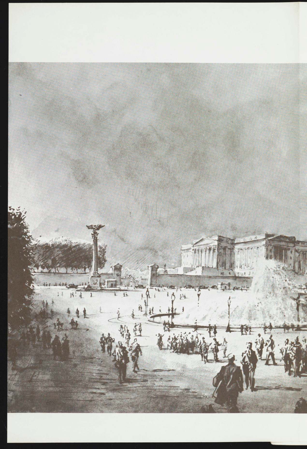
The rendering is by Nicholas Solovioff, an architectural illustrator whose drawings appeared regularly in Fortune, Sports Illustrated, and Architectural Forum. This is the left half of the two-page spread he made for the President’s Council.
You can see what they were trying to do. A monumental new White House gate, flanked by sturdy columns. The Treasury colonnade on the right. Modernist buildings on the north side, fronted by a glass-roofed shopping arcade. Crowds of pedestrians. Trees. Open space on a ceremonial scale America had never built before.
The Council’s own description, from the July 1964 Architectural Forum:
The new White House gate would be large enough to be seen from far down the Avenue, would be designed by a master, would be strong enough to command respect, and would be enhanced by being sturdily flanked. Behind the gate would be a smaller square, Treasury Place, intended as a White House forecourt.
The belvedere along the north side would sit 20 feet above the square, 200 feet deep, covered with “tree planters, tables for outdoor restaurants, and convenient seats.” Underneath the belvedere: a glass-roofed shopping arcade acting as “a dramatic gateway to the shopping district.”
The east edge was reserved for “a new press and broadcasting center.” The existing National Press Building would be the square’s “most prominent displacee,” which is a polite 1964 way of saying “we’re tearing that down.”
The south was “given over to culture and entertainment.” The District Building would be converted into an auditorium for “ceremonies, symphony, or theater.”
And then the sentence that really lands. The square, the Council wrote, would be:
a place of national celebration, of national mourning, of greeting for the nation’s guests.
They were trying to build an American Place de la Concorde.
Underneath, 14th and F Streets would tunnel beneath the square. A 600-car garage at the same subsurface level. Fountains above. “Seats, tables, vending accommodations, and umbrella-shaped shelters, all removable easily in advance of parades.”
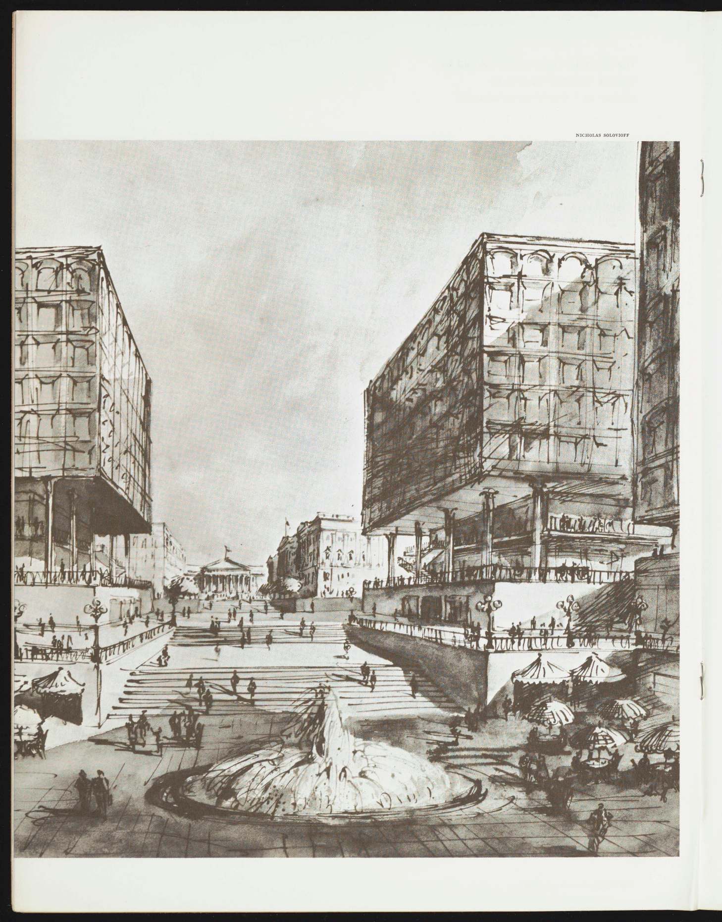
The cross-axis ran north from Pennsylvania Avenue at the National Archives. Stone steps. Fountain. Arcaded buildings flanking. Outdoor cafes. It would have anchored the Northern Triangle superblocks, the Council’s counterweight to the existing Federal Triangle across the avenue.
This cross-axis was never built either.
Kennedy Is Dead. The Plan Lives. Briefly.
November 22, 1963. Dallas.
The Council kept working. The report was already drafted. Owings and his team finished the plan in the months after the assassination and delivered it to Lyndon Johnson, who had inherited the whole project.
LBJ liked what he saw. In 1964 he converted the President’s Council into the President’s Temporary Commission on Pennsylvania Avenue and kept Owings on as chairman. The American Institute of Architects endorsed the plan at its 1964 convention in St. Louis. The Commission of Fine Arts approved it in principle.
For a moment it looked like the thing might actually happen.
Then money.
Johnson’s attention moved to Vietnam and the Great Society. The Temporary Commission scaled National Square down to half its original size and started looking for private development partners to help pay for the northern quadrant. The partners proved to be hard to find.
The plan was still alive. It just wasn’t being built.
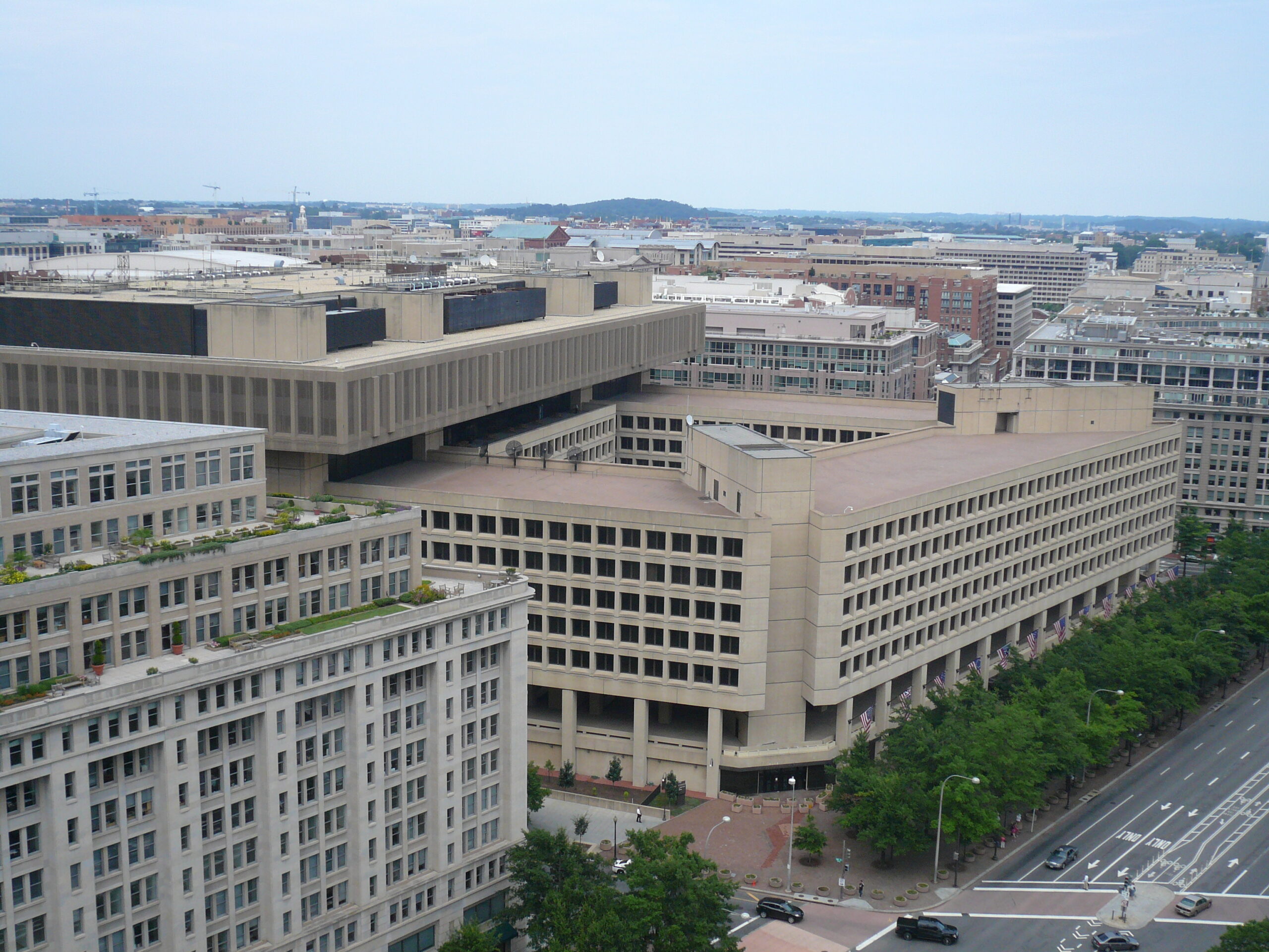
The FBI Builds a Fortress
What killed the 1964 vision wasn’t a budget line. It was a building.
The J. Edgar Hoover Building. Started as a design problem in 1963. Finished as a concrete fortress in 1975. A full block of blank Brutalist walls on Pennsylvania Avenue’s north side.
Owings fought the FBI on every design demand. He wanted pedestrian arcades along the Hoover Building’s ground floor. He wanted retail. He wanted restaurants and shops and the kind of street life Moynihan had been demanding since 1962.
The FBI wanted a fortress. Specifically, in the Bureau’s own words, they wanted “a structure which was bomb-proof on the first few stories and had but a few, tightly secured access points.”
The FBI’s argument against arcades is, even now, hard to read without blinking:
Rapists and muggers would hide in the arcades, making Pennsylvania Avenue unsafe for pedestrians and workers.
On September 14, 1967, the National Capital Planning Commission sided with the FBI. No arcades. No retail. No street life.
John Woodbridge, who had been Chief of Design on the 1964 plan, said later that he was “upset with the way the massive, Brutalist-style J. Edgar Hoover Building disrupted foot traffic and retail trade.”
Forty years later, in 2009, the NCPC and the Commission of Fine Arts admitted in their Monumental Core Framework Plan that they had been wrong. The Hoover Building’s “fortress-like presence” and security requirements had “prevented street-level public uses around the entire block,” ultimately preventing Pennsylvania Avenue’s envisioned revitalization.
Which is bureaucratic English for: we picked the wrong side in 1967.
The PADC Era and the Smaller Dream
The second act of this story belongs to two men: Owings and Moynihan.
October 27, 1972. Congress passed the Pennsylvania Avenue Development Corporation Act. Nixon signed it on October 30. PADC organized officially in April 1973, with retired Air Force general Elwood Quesada as its first chairman. Owings moved from the Temporary Commission to PADC’s board. Moynihan, by then Nixon’s urban affairs adviser, got involved too.
They pushed. They made deals. They fought preservation battles.
PADC approved its final master plan in October 1974. You can read about what it actually built in our 1974 Pennsylvania Avenue revitalization plan post, but here’s the short version.
The E Street tunnel was dead. The 10,000 underground parking spaces were dead. Pennsylvania Avenue was not paved in brick. There was no monumental White House gate.
The Old Post Office, which the 1964 Council had wanted demolished down to the clock tower, was saved and restored. The Willard Hotel, which the 1964 plan would have cleared, was saved by a 1974 legal fight and restored in 1986.
National Square, the 800 by 900 foot civic plaza that was supposed to anchor the whole avenue, would come last. Smaller. Differently designed. By different architects.
What Stands There Now
November 1, 1980. Western Plaza opens at 14th and Pennsylvania. Designed by Venturi, Rauch & Scott Brown. A much smaller plaza, maybe a quarter the size of what Owings wanted. Paved with an inlaid map of Pierre Charles L’Enfant’s 1791 plan for Washington, in black granite and white marble.
An 18th-century plan laid into the pavement on the ground that had been reserved for a 20th-century one.
In 1988 it was renamed Freedom Plaza in honor of Martin Luther King Jr., who worked on “I Have a Dream” at the Willard next door.
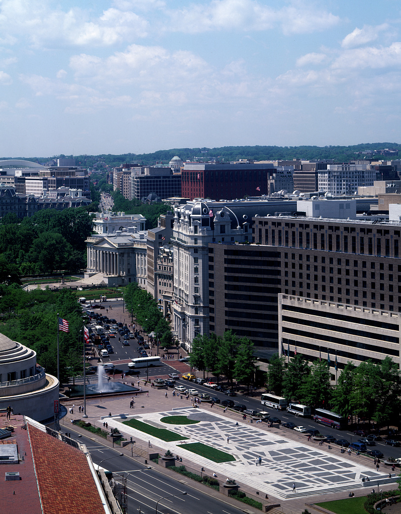
Walk to 14th and Pennsylvania today. Stand in the middle of Freedom Plaza and look west toward the Treasury.
You’re standing where Owings drew 800 by 900 feet of open plaza. You’re standing where he wanted a monumental White House gate, a belvedere north of you, a glass-roofed shopping arcade under the belvedere, a press center to the east, and the District Building converted into an auditorium on the south.
Underneath your feet, in the 1964 plan, 14th Street and F Street would be running through tunnels. A 600-car garage would be operating at tunnel level. Above ground, removable umbrellas for parade day.
None of it exists. Not the gate, not the glass arcade, not the tunnels, not the brick paving on Pennsylvania Avenue, not the 10,000 parking spaces below ground, not the tiered sidewalks, not the National Square.
Nathaniel Owings died in 1984. The plan he’d spent a decade on was mostly still on paper.
Well, of course some of those tunnel;s on the map did get built: 12th Street, 9th Street and 3rd Street (here called the “Center Leg of Inner Loop”) all go under the Mall. E Street? Meh.
These tunnel proposals appeared in a document, iIRC from 1961 “Downtown Progress”.
I have some images from that report reproduced here:
http://wwwtripwithinthebeltway.blogspot.com/2014/12/previous-center-leg-air-rights.html