
This is a Capital Transit Company schematic from 1936. It shows the numbered routes that ran through downtown Washington on a Sunday, each line representing a set of rails embedded in the pavement you’re standing on right now. Route 10 to Rosslyn. Route 20 to Cabin John. Route 22 to Beltsville. Route 80 to Catholic University. Route 30 to Friendship Heights. Route 76 to 7th and Florida, NW.
Twenty-six years later, every one of them was gone.
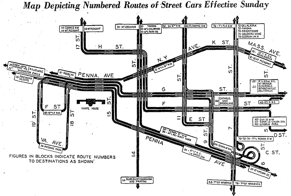
What the Map Shows
The schematic is centered on the White House. The grid runs from 19th Street on the west to 6th Street on the east, from Massachusetts Avenue at the top down to C Street. Each numbered box is a route that picks up its passengers downtown and heads out to the neighborhoods listed inside.
Read them like a phone book of the city:
Route 10 to Rosslyn, out across the Key Bridge. Route 22 to Washington Circle. Route 20 to Cabin John, the branch line that ran out along what is now MacArthur Boulevard to the Potomac. Route 30 to Friendship Heights. Route 30 to the Bureau of Engraving and Printing. Route 32 to Takoma. Route 34 to Potomac Park. Route 44 to Connecticut Avenue and Union Station. Route 40 to Lincoln Park. Route 42 to Mt. Pleasant. Route 52 to 14th and Colorado. Route 54 to 14th and Park Road. Route 60 to 11th and Monroe. Route 62 to U and 14th, and to the 7th Street Wharves. Route 70 to Georgia Avenue and Alaska, to Takoma, to Brightwood, to the Soldiers’ Home, to Georgia and New Hampshire. Route 74 to the Soldiers’ Home by a different path. Route 76 to 7th and Florida, and down to the wharves. Route 78 to the wharves. Route 80 to Catholic University in Brookland.
And the suburban lines reaching across the District line into Maryland: Route 20 out to Mount Rainier. Route 22 to Riverdale, Branchville, and Beltsville. Route 12 to Seat Pleasant. Route 15 to Kenilworth.
That’s one map. One Sunday’s schedule. A system carrying nearly half a million rides a day.
A Brand-New Company on an Old Track
“Capital Transit Company” had existed for three years when this map was printed.
On January 1, 1933, a Congress-approved reorganization merged Capital Traction Company into a subsidiary of the Washington Railway and Electric Company, and renamed the combined operator Capital Transit. The two original companies had been running most of the District’s streetcar lines since the 1890s, each with its own cars, its own transfers, and its own fare structure. Congress had been trying to force them together for a decade. The Depression finished the argument.
The new Capital Transit Company inherited both systems. The numbered-route scheme that runs across this map is one of the visible signs of that unification: instead of a “14th Street line” and a “Mt. Pleasant line” you had Route 52 and Route 42, each a piece of a single network with transfers at the downtown hubs.
The streets were still the same. DC streetcars ran, by act of Congress, on underground electric conduit in the central city rather than from overhead wires. The rails and the pavement around them had to be maintained to a higher tolerance than in any other American city. When you see photographs of downtown Washington in this era, the tracks are always visible in the asphalt.
The Peak
1936 was the peak, or close to it.
Franklin Roosevelt’s New Deal had poured tens of thousands of new federal workers into the city, most of whom rode the streetcars to work. The Bureau of Engraving and Printing had its own route. Catholic University had its own route. So did the Soldiers’ Home, the 7th Street Wharves, the Navy Yard, and Lincoln Park. Ridership was headed toward a wartime high of roughly a million boardings a day by 1944.
The cars themselves were a generation out of date. Most of the rolling stock dated to the 1910s and early 1920s: wood-bodied, tall, slow on hills. The company knew it. In October 1937, the first of Capital Transit’s new streamlined PCC streetcars, built by the St. Louis Car Company, entered service in an orange-and-silver paint scheme that would become the visual identity of the system for the next quarter century. Capital Transit would eventually roster close to five hundred PCCs.
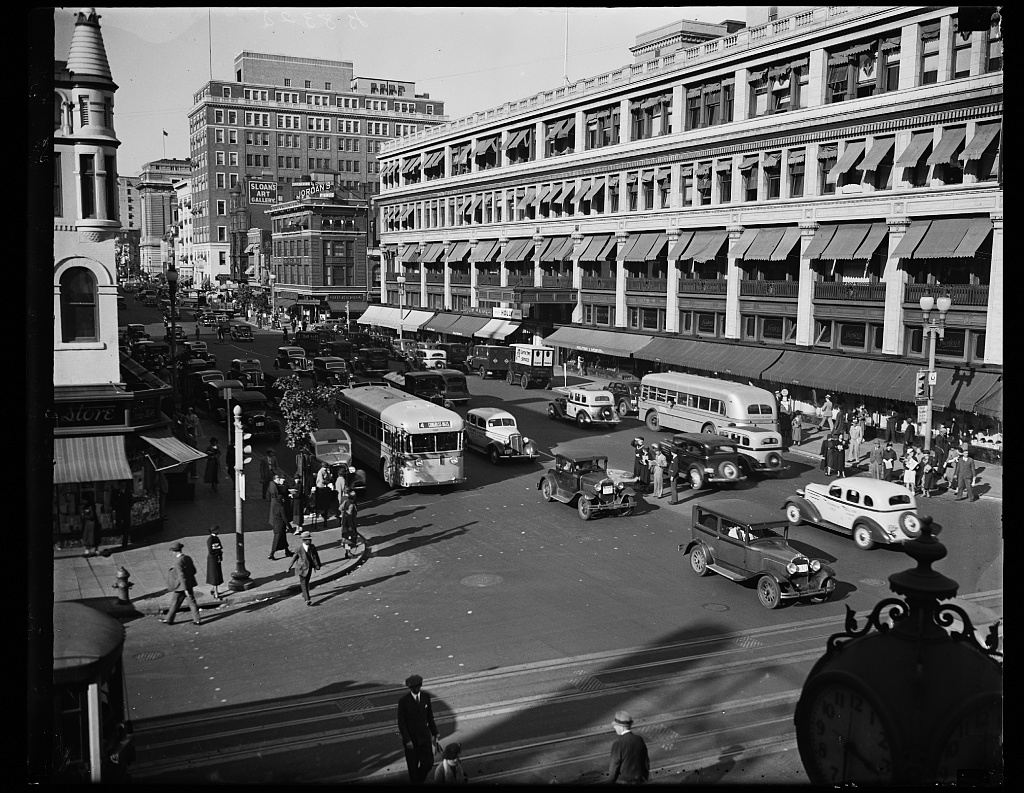
You can see the pre-PCC downtown streetscape in a Harris & Ewing photograph taken the year before this map was printed. Tracks run down the middle of the street. The conduit slot is visible between the rails. Two Capital Transit buses, a Ford sedan, and a patchwork of pedestrians fill the block. No overhead wires anywhere.
What Was Already Disappearing
Look at the map again and pick out the bus-marked routes. There aren’t many yet. There will be more.
The first substantial round of DC streetcar abandonments happened in the early 1930s, just before the merger. Bus substitution on low-ridership lines kept accelerating through the decade. The Ninth Street line, one of the oldest in the system, had its streetcars pulled in 1936 and replaced by buses running in from Hyattsville. The Evening Star covered the re-routing as a civic occasion. “The first line of transportation for Ninth Street since street car service was discontinued last year,” the Star reported on March 14, 1937.
It was a pattern that accelerated in the 1940s and ran out in 1962. The postwar Capital Transit owners, especially Louis Wolfson after 1949, saw more profit in buses and in the real estate under the rail yards than in running rail cars. A 1955 wage strike, Congressional revocation of Capital Transit’s franchise in 1956, and the immediate sale to financier O. Roy Chalk set the final trajectory. Chalk’s successor company, DC Transit, ran the last streetcar in the District on January 28, 1962. A few of the cars survived in service or in preservation and can still be ridden at the National Capital Trolley Museum in Colesville.
We’ve written about the tail end of the system, including the Silver Sightseer, the air-conditioned tourist trolley Chalk rolled out as a swan song. We’ve also written about how Metro Center and the Metro lines replaced the downtown streetcar hubs this map depicts, and about the long-abandoned Capital Traction Company powerhouse that once electrified it all.
The Ghost Network Under Your Feet
Most of this 1936 map is still legible in the modern city, if you know where to look.
The numbered Metrobus routes that now run the same corridors are roughly descended from the streetcar routes. The 30s buses still run down Pennsylvania Avenue. The 90-series buses still run up 14th Street. The S2 and S4 still climb 16th Street the way the streetcars did. When you sit on a Metrobus heading out Georgia Avenue, you are, at some level, on Route 70.
You can still sometimes see the trackbeds, too. When a utility cut exposes the pavement on Pennsylvania Avenue, the old rails and the conduit slot come up out of the asphalt where they’ve been buried since the fifties and sixties. The Tennallytown streetcar line that killed a White House gardener in 1913 left its right-of-way along Wisconsin Avenue. The Dupont Circle trolley tunnel, excavated in the 1940s and abandoned with the rest of the system, is still down under the fountain. Every so often someone proposes turning it into a food hall.
By 1949, just thirteen years after this map was published, the system was already a historical curiosity. Here is what you could see on 15th Street in September of that year:
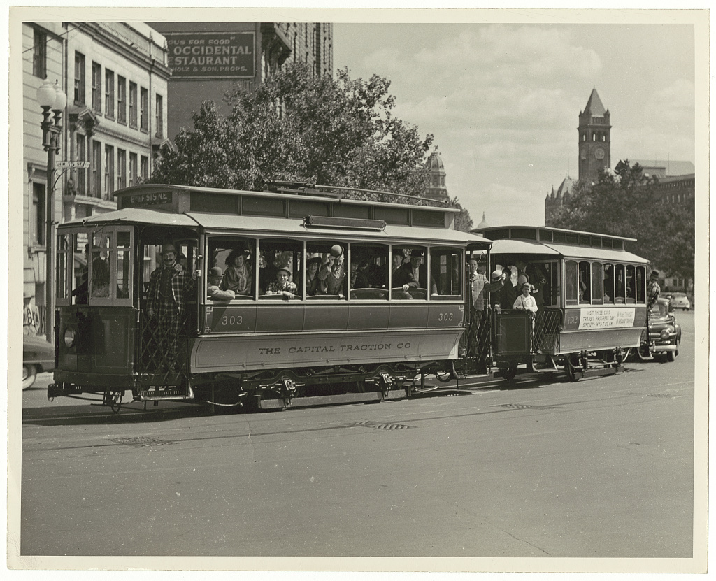
A streetcar fan club, running an open-sided “Gay Nineties” excursion car down 15th Street as a tourist novelty. The caption painted on the car reads “The Capital Traction Co.”, the predecessor company the 1933 merger had erased sixteen years earlier. The Occidental Restaurant sign is visible in the upper left. The Old Post Office clock is telling the right time.
1936 is the moment in the middle, when a system that seemed permanent was printing new route schematics for a Sunday rollout. Pick a number on the map. Pick Route 22 to Beltsville. Pick Route 80 to Catholic U. Ride the line in your head, all the way to the end.
Then get off, walk back, and try to find the rails in the street.
Love your map of DC’s old streetcar lines. Where did you find it?
Not sure if this exact map is there but there are some like it in “100 Years of Capital Traction”
Interesting to see that Metrobus still uses some of the old streetcar route numbers for the same or similar routes (like the 30s, 50s, etc.).