
Who owned the land that became Washington, DC? It wasn’t the government, and it wasn’t George Washington. In the spring of 1791 the ground under today’s White House, Capitol and National Mall belonged to a small group of Maryland planters, merchants and farmers.
Washington had to talk them out of it, and he did it in Georgetown in three days.
He rode into town on Monday, March 28, 1791, and took lodging at Suter’s tavern, the Fountain Inn. By Wednesday, March 30, the landowners had signed an agreement handing their farms over in trust for the new federal city. They became known as the original proprietors.
You’ll often read that there were 19 of them. The National Park Service uses that number, and so did this post when we first wrote it in 2012.
The agreement itself carries 18 names, and a few owners never signed at all. The real count depends on who you include, and we’ll get to that.
One more thing up front: this wasn’t eminent domain, and it wasn’t exactly a sale or a donation either. It was a deal, and a pretty clever one.

Bought or Donated? A Little of Both
Congress set the rules in the Residence Act, approved July 16, 1790. It put the permanent seat of government on the Potomac and let the President’s commissioners “purchase or accept” land for the federal city. Washington named three commissioners in January 1791: Thomas Johnson, David Stuart and Daniel Carroll.
Instead of buying the city outright, Washington got the landowners to sign an agreement. It opens like this:
We the subscribers, in consideration of the great benefits we expect to derive from having the Federal City laid off upon our Lands, do hereby agree and bind ourselves, heirs, executors & administrators, to convey in Trust, to the President of the United States, or Commissioners, or such person or persons as he shall appoint, by good and sufficient deeds in fee simple, the whole of our respective Lands, which he may think proper to include within the lines of the federal City
Here’s how the deal worked. The President could lay out the city however he pleased, and land that went into streets was given up for nothing.
Land taken for public buildings, squares and other public uses was paid for at twenty-five pounds per acre, which the Park Service puts at about $66 an acre.
Everything left over was cut into building lots, and the lots were split “fairly and equally” between the public and the old owners. The public sold its half to pay for the government’s buildings. The proprietors kept their half to sell themselves.
There were sweeteners, too. The owners kept the timber, and they kept farming their land until the lots were sold and occupied. Where the street plan allowed it, owners could keep a house, its outbuildings or a family graveyard by paying the public twelve pounds ten shillings per acre, half the going rate.
Why would anyone agree to that? Because half the lots in a capital city looked worth a lot more than a whole farm in rural Maryland. The agreement says it right in the first line: “the great benefits we expect to derive.”
Georgetown vs. Carrollsburg
The landowners came in two rival camps. One group held land near Georgetown. The other held land to the southeast, near Carrollsburg, a town that had been laid out on paper around 1770 by Charles Carroll, father of Daniel Carroll of Duddington, and was still only a paper town in 1791.
Each side wanted the public buildings near its own land. Both sides assumed the federal city would cover a few hundred acres at most, according to the editors of Washington’s papers.
Washington was already working the angles. On February 17, 1791, he told two Georgetown men, William Deakins Jr. and Benjamin Stoddert, to quietly buy up lots in Hamburgh in a way that “may not excite suspicions of their being on behalf of the public.” He hoped to get David Burnes’s farm for £15 or £17 an acre.

Then he showed up in person. His diary entry for March 28, 1791, says he left Bladensburg at half past six and was met a few miles out by “the principal Citizen[s] of the place.” He spent the next morning riding over the ground in a thick mist.
By the way, nobody knows exactly where Suter’s stood. Our 2012 version of this post put it at 31st and K Streets NW, following a 1955 Park Service finding.
A 1986 archaeological study found that corner wasn’t occupied until about 1810, according to Streets of Washington. We dug into that mix-up in our Old Stone House story.
That day, March 29, he called the landowners together. Here’s how he put it:
Finding the interests of the Landholders about George town and those about Carrollsburgh much at varience and that their fears & jealousies of each were counteracting the public purposes … I requested them to meet me at Six oclock this afternoon at my lodgings, which they accordingly did.
… instead of contending which of the two should have it they had better, by combining there offers make a common cause of it and thereby secure it to the district.
That evening meeting is where Washington first said out loud how big the city would be, the editors of his papers note. It would take in both the Georgetown and the Carrollsburg land. In his letter to Jefferson he put the whole at “from three to five thousand acres.”
It worked. On March 30 Washington wrote that the owners had decided that by fighting over “the shadow they might loose the substance.” They agreed to give up half of their land inside the city lines for public purposes and signed the agreement. He left Georgetown that day, dined in Alexandria and was home at Mount Vernon by evening.
“Even the Obstinate Mr. Burns”
The next day, March 31, 1791, Washington reported to Secretary of State Thomas Jefferson. He opened with a little victory lap: “Having been so fortunate as to reconcile the contending interests of Georgetown and Carrollsburg, and to unite them…”
He laid out the terms. The ground would be surveyed and laid off as a city, “which Major L’Enfant is now directed to do.” The present proprietors “shall retain every other lot.” Land for public use would be paid for “at the rate of Twenty five pounds per acre.” And “No compensation is to be made for the ground that may be occupied as streets or alleys.”
All the principal landholders had signed, he wrote, except the buyer of one property who hadn’t shown up. Then came the best line in the letter:
Even the obstinate Mr. Burns has come into the measure.
More on him in a minute.
The Original Proprietors: 18, 19 or More?
The agreement of March 30, 1791, is published in the George Washington Papers. Twelve men signed the original, with John Suter, the tavern keeper, among the witnesses.
The first twelve were Robert Peter, David Burnes, James M. Lingan, Uriah Forrest, Benjamin Stoddert, Notley Young, Daniel Carroll of Duddington, Overton Carr, Thomas Beall of George, Charles Beatty, Anthony Holmead and James Peerce.
Six more names were added later: Abraham Young, Edward Peerce, John Waring (signed by Stoddert under a power of attorney), William Prout, William King and Eliphas Douglass (signed by Robert Peter as his attorney). That’s 18 proprietors on the paper.
William Prout was the no-show in Washington’s letter. He was an English merchant from Baltimore who had just bought about 500 acres from Jonathan Slater, running from the east side of Jenkins Hill to the Eastern Branch, at £20 an acre. Washington sent a rider after him, and Prout signed soon after.
Three landowners never signed at all: Joseph Coombs Jr., and Enoch and Thomas Jenkins. The agreement also left out the people who owned lots in the old town plats of Carrollsburg and Hamburgh. They got separate deals.
And then there’s Samuel Davidson, a Georgetown merchant who shows up on nearly every list of original proprietors. He didn’t sign it as a landowner. His name shows up only as the witness to Abraham Young’s signature.
Shortly after it was signed, he bought Edward Peerce’s share of the Port Royal tract. Historian Bob Arnebeck writes that Davidson paid $6,000 plus a 500-acre farm on the Gunpowder River north of Baltimore.
So where does 19 come from? We couldn’t pin it down. The Park Service’s history of the city’s parks says the agreement was signed by “nineteen original proprietors.” The Histories of the National Mall project, from George Mason University, says 15 landowners negotiated with Washington.
Funny enough, there is a nineteen in the record, just not this one. A February 21, 1791 agreement bound nineteen Hamburgh proprietors, who owned 48 town lots, to convey them to the government.
The safe answer: 18 proprietors signed the 1791 agreement, a handful of others held out or bought in right after, and “19” is the number that stuck.
The 1874 Map of the Original Landowners
If you want to see who owned what, this is the map. It’s titled “Sketch of Washington in Embryo, viz: Previous to its Survey by Major L’Enfant, 1792.” Dated 1874, it was compiled from the research of Dr. Joseph M. Toner, with the help of civil engineer S. R. Seibert.
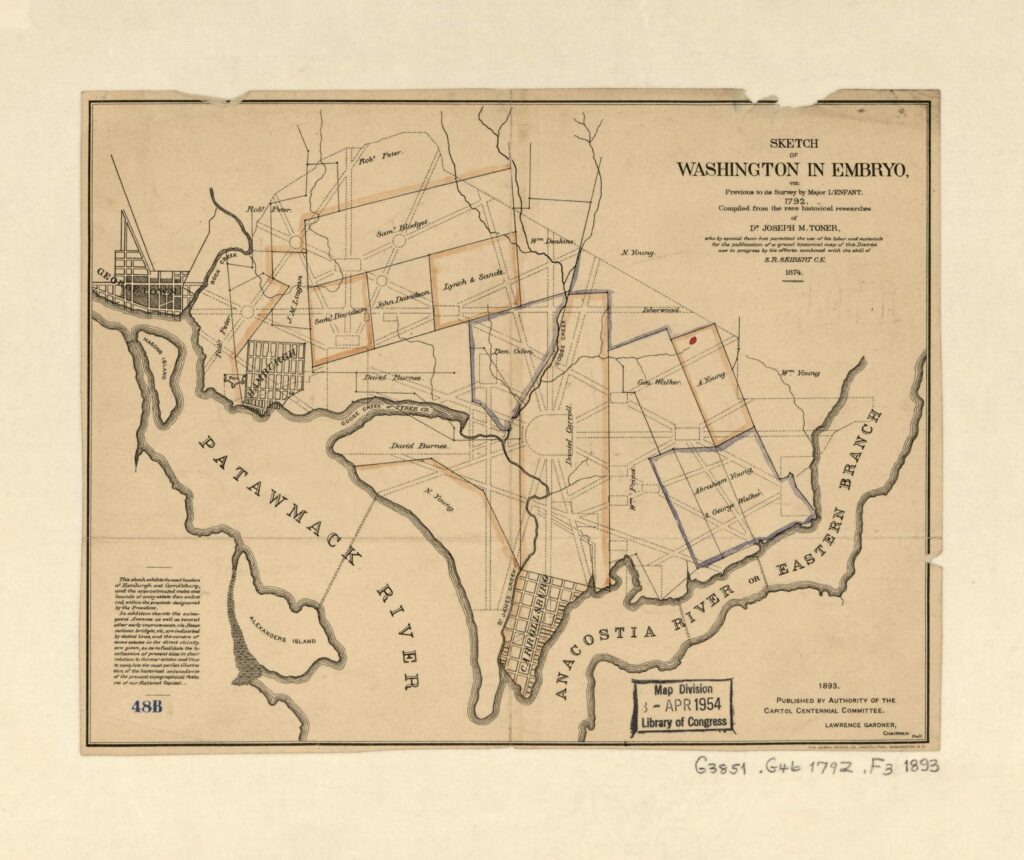
The copy at the Library of Congress is a facsimile of the 1874 map, printed in 1893 by the Capitol Centennial Committee. The Library describes it as a cadastral map showing landholdings in central Washington with the owners’ names.
Zoom in and the names jump out. David Burnes is near the mouth of Tiber Creek, Daniel Carroll is across the middle and N. Young is on the Potomac shore. Abraham Young, Wm. Prout and Robert Peter are there too.
You’ll also spot names that aren’t on the agreement, like Samuel Davidson and Lynch & Sands, because the map shows the land as it stood in 1792, after some of it had already changed hands.
There’s another version of this idea, with the old tract names drawn in: Port Royal, Jamaica, Beall’s Levels, Duddington Pasture, Hop Yard and Widow’s Mite.

David Burnes and the White House Land
Now, the obstinate Mr. Burns. He spelled it Burnes. He was a farmer whose family had held the land since the 1690s, and his tract sat right in the middle of the planned city, with a tobacco farm, orchards and the family house, according to Boundary Stones. Boundary Stones puts his tract at about 600 acres.
His land lay mostly north of what is now Constitution Avenue. It included the ground under the White House, the South Lawn and the Ellipse, according to the Histories of the National Mall project.
Washington wanted that land badly. In February 1791 he told his agents that if Burnes held out for £20 or £25 an acre, he “could wish his lands to be purchased even at those prices, rather than not obtain them.”
Burnes signed on March 30. On June 28, 1791, he executed his deed of trust to Thomas Beall (son of George) and John Mackall Gantt, the trustees for all the proprietors. The stated price was five shillings. The deed spells out how the lots would be split if nobody agreed on another method:
…such residue of the said lots shall be divided, every other lot alternate to the said David Burns, and it shall on that event be determined by lot whether the said David Burns shall begin with the lot of the lowest number laid out on his said lands or the following number…
A coin flip, more or less, for the future of downtown.
Then there’s the famous story. According to legend, Washington went to Burnes’s cottage to win him over and got an earful, including something like “what would you have been if you had not married the rich Widow Custis?” Boundary Stones calls the whole scene legendary. It only turns up in later local histories, and the details change with each telling.
Burnes kept farming after the deal, as the agreement allowed. He reportedly fenced off ground in the path of Pennsylvania Avenue to protect his crops. He sold off parcels over time and held out for good prices, sold the last of his lots in 1798, and died in 1799.
His daughter Marcia became one of the richest heiresses in the new city. She married John P. Van Ness, a New York congressman who later served as mayor, and they built a mansion on what was left of the Burnes property.
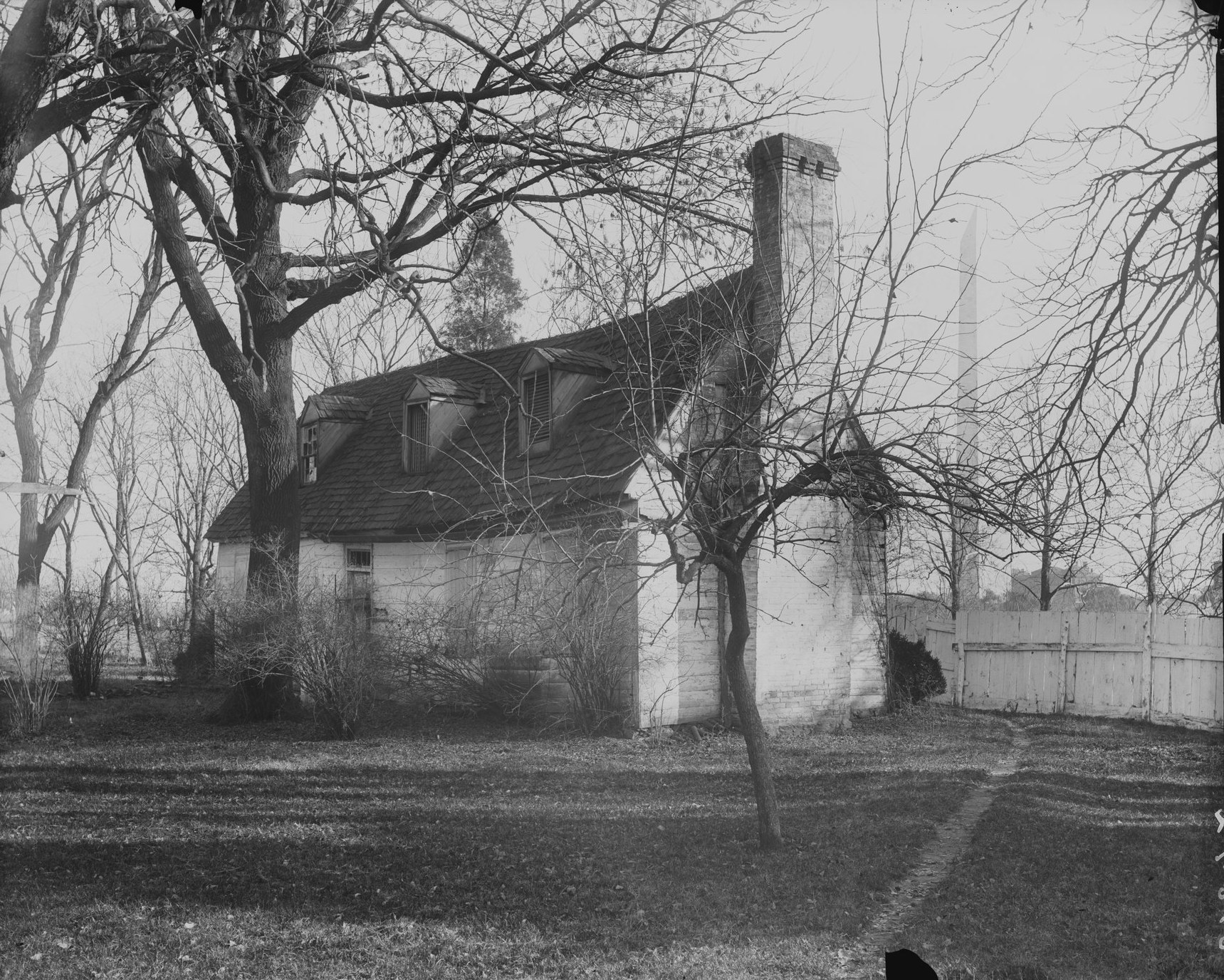
The little Burnes cottage on 17th Street hung on into the 1890s. Frances Benjamin Johnston photographed it with the Washington Monument rising faintly behind it, the photo at the top of this post. It was torn down in 1894, and the Pan American Union building now stands on the site, according to the Library of Congress.
Daniel Carroll of Duddington and the House in the Street
Daniel Carroll of Duddington held the biggest estate in the new city. Most of what became the Mall and all of the land under the Capitol was his, according to the Histories of the National Mall project. Don’t confuse him with Daniel Carroll the commissioner, a different man.
That hilltop had a long paper history. Back in 1663, a tract on or beside this hill was laid out for a Charles County gentleman named Francis Pope. It was called Rome, and it ran to an inlet called Tiber.
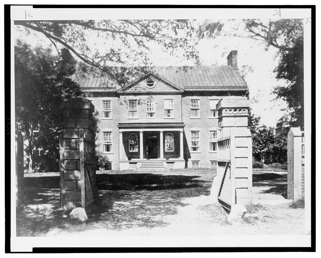
In 1791 Carroll started building a new house, and it sat in one of L’Enfant’s planned streets.
Around November 20, 1791, L’Enfant had workmen start tearing it down. Carroll went to court and got an injunction, but by then the house was partly torn down.
Washington was not amused. On December 1, 1791, he wrote the commissioners about “the demolition of Mr Carrolls house by Major L’Enfant, against his consent,” and agreed that L’Enfant “had no such authority from me.”
Before he even heard the house was down, Washington had offered Carroll a compromise. He could have it taken down and rebuilt the next spring “without any expence to you,” or finish it and live in it for six years before it was removed.
Carroll’s house was only one of L’Enfant’s fights with the commissioners. Washington cut him loose in late February 1792.
Notley Young, Uriah Forrest and the Rest
Notley Young owned the land south of Carroll’s along the Potomac, including the southern part of today’s Washington Monument grounds and the shoreline facing what is now East Potomac Park, which was still river and marsh. His house, with its outbuildings, gardens and quarters for the people he enslaved, stood until after the Civil War.
Uriah Forrest, a Revolutionary War officer wounded at Germantown and Brandywine, hosted Washington and the commissioners for dinner on March 29. He and Benjamin Stoddert owned nearly 1,000 acres north of Georgetown inside the surveyed district.
Samuel Davidson, the late buyer, deeded his Port Royal land expecting it to become part of a grand entrance to the President’s House. When the plan changed, he spent the 1790s arguing with the commissioners. He complained that “at this day there is no real fixed plan for the City of Washington,” according to the White House Historical Association.
What Happened Next
The survey was already under way. Andrew Ellicott, helped in the first months by Benjamin Banneker, ran the lines of the ten-mile square and set the boundary stones around it, while L’Enfant drew the plan.
On September 8, 1791, the commissioners met with Jefferson and Madison and named the city after Washington and the territory after Columbus. The next day they sent L’Enfant their system for naming the streets by letters and numbers.
The first public sale of lots opened October 17, 1791. It didn’t exactly set the world on fire. Thirty-five lots sold for £3,292 in all, but the commissioners bought four of them themselves to keep prices from sliding, so only 31 went to private buyers.
Most lots went for £75 to £120, and the best price was £201. Commissioner David Stuart blamed the weather, and the sale was closed early on the third day.
The proprietors’ big payday came slowly. The city grew in fits and starts, and the government didn’t arrive until 1800, when President Adams made the trip down from Philadelphia.
Today the Capitol sits on Carroll’s land. The southern edge of the Washington Monument grounds sits on Notley Young’s. And the obstinate Mr. Burns’s farm is the President’s backyard.
We dug this one up with help from AI and checked it against the original records below. Here’s how we use AI.