Skip to content
Ghosts of DC

Ghosts of DC

  • The Best Of
  • Neighborhoods
    • Southwest DC
      • Waterfront
    • Maryland
      • Gaithersburg
      • Rockville
      • Bethesda
      • Hyattsville
      • Silver Spring
      • Bladensburg
    • Virginia
      • McLean
      • Falls Church
      • Alexandria
      • Vienna
      • Arlington
    • Southeast DC
      • Congress Heights
      • Navy Yard
      • Capitol Hill
      • Anacostia
    • Northeast DC
      • Trinidad
      • Woodridge
      • Deanwood
      • Brookland
    • Northwest DC
      • Tenleytown
      • Park View
      • Friendship Heights
      • Brightwood
      • Crestwood
      • Sheridan-Kalorama
      • The Palisades
      • Logan Circle
      • Petworth
      • Glover Park
      • Bloomingdale
      • Georgetown
      • Woodley Park
      • Dupont Circle
      • Columbia Heights
      • Cleveland Park
      • Adams Morgan
      • Mt. Pleasant
      • Chevy Chase
      • Cathedral Heights
      • Chinatown
    • Lost Neighborhoods
      • Hell’s Bottom
      • Swampoodle
      • Murder Bay
  • Notable People & Places
    • Places
      • Washington Monument
      • Library of Congress
      • The White House
      • The Capitol Building
      • Dulles Airport
    • People
      • Franklin D. Roosevelt
      • Calvin Coolidge
      • Officer Sprinkle
      • Dwight D. Eisenhower
      • Warren G. Harding
      • William McKinley
      • Abraham Lincoln
      • John F. Kennedy
      • Teddy Roosevelt
      • Woodrow Wilson

Day: August 31, 2017

A Fascinating Map of D.C. Showing Where You Could and Could Not Park in 1922

November 7, 2023August 31, 2017 by ghostsofdc
Parking map of the congested area of Washington, D.C. (1922)

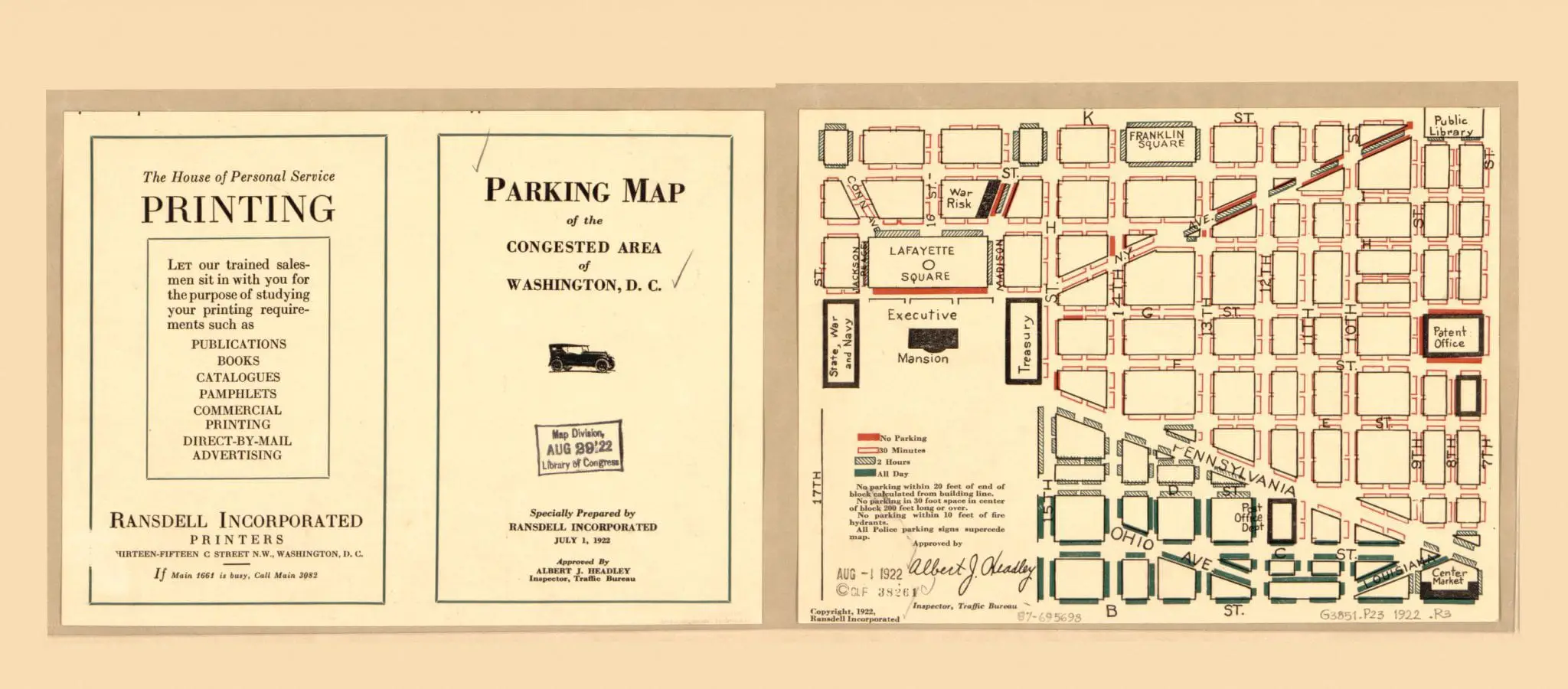
Take a look at this fascinating map of Washington, D.C. from 1922, showing where you could and could not park in the congested city. Click on it to zoom in on the details. Source: Library of Congress.

Categories GoDCers Love Maps Tags 1920s
© 2026 Ghosts of DC • Built with GeneratePress