Saturday, May 25th, 2013

Tag Archives: Anacostia

Feed Subscription

Then and Now: Bury’s Drug Store to Uniontown Bar & Grill

Bury's drug store around 1919

Well, this was a hopefully step to revitalize Anacostia, but the most recent owner made a couple bad decisions. Here is the building as it looked around 1919 as Bury’s drug store. And below is the current Google Street View of what used to be Uniontown Bar and Grill. The beautiful old building might have life again, according to the ... Read More »

Good Hope Road in 1916

Anacostia and Good Hope Road in 1916

Take a look at how different Good Hope Road in Anacostia looked in 1916. And below is the Google Map of the same area, with a pin marking the intersection of Good Hope Road and 19th Pl. SE. Read More »

Anacostia Street Frozen in Time (1919)

Anacostia home being constructed circa 1919

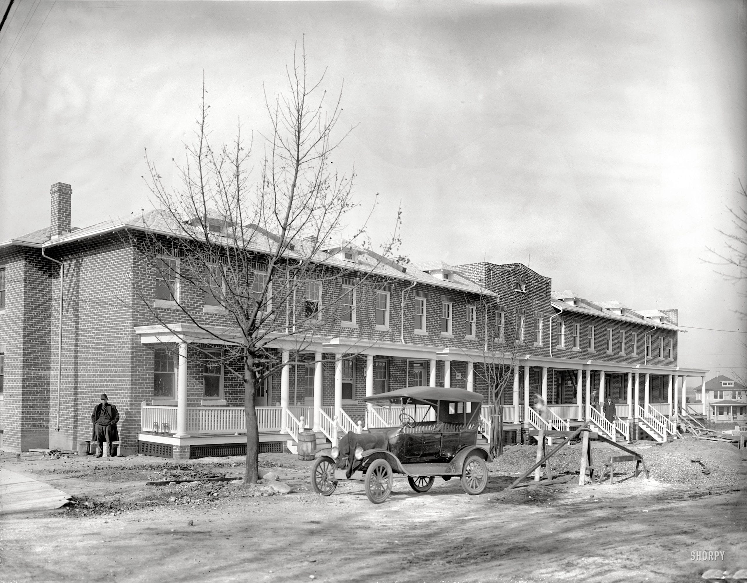
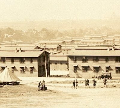
Here is a terrific shot of homes being built in Anacostia. This was taken around 1919 and this row appears to be the 1900 block of 16th St. SE. Check out the Google Street View below (it’s not quite the same angle because of the trees obstructed the view). This makes for a great “Then and Now.” Read More »

Grover Cleveland Gets Lost in 19th Century Anacostia

Grover Cleveland

This is a guest post by John (from The Lion of Anacostia), cross-posted here. While trying to confirm President Hayes visited Douglass at Cedar Hill, I came across this news item telling of President Grover Cleveland (the 22nd and, later, the 24th President) and his trusted friend Daniel S. Lamont getting, what appears to be, lost in 19th century Anacostia, lost on the Southside. In Life and Times Douglass lauds ... Read More »

Violence on Streets of Old Anacostia (1886)

Baltimore Sun - Letter From Washington

This is a guest post by John (from The Lion of Anacostia), cross-posted here. I walk the streets, alleys, back-cuts, and lounge on the corners of Anacostia everyday, every hour, every minute. Tour an abandominium or two. Reports and the widely held perceptions of violence and criminality in Anacostia, as I see it and know it, are over-rated. But that ... Read More »

To See Fairlawn Means a Lot

Fairlawn real estate advertisement from the Washington Herald - July 22nd, 1911

This is an advertisement for new development and real estate across the Eastern Branch, near Anacostia. Click on the ad for a closer look at what is a harsh window into a very different (and blatantly racist) time in Washington. Reading these anachronistic advertisements over 100 years later still makes you cringe at the way things were back then. Fairlawn ... Read More »

Congress Heights: The Healthiest and Most Delightful Suburb of Washington

Congress Heights advertisement - May 17th, 1902 (Washington Times)

Admittedly, I do not focus enough east of the river. I was doing a little digging around the Library of Congress archives and came across this gem. This is an advertisement for homes in Congress Heights, published on May 17th, 1902 in the Washington Times. Read through the whole thing. It’s amazing. Related articles Move to Cathedral Highlands: An Unobstructed ... Read More »

Three Things About Poplar Point and Anacostia Flats

Bonus Army eviction in 1932 (Wikipedia)

If you’re fortunate enough to be participating in WABA’s “Down the Tubes” ride tomorrow, the last stop on your journey is going to be Poplar Point. Probably 70% of District residents don’t know what this is or where it is, but a number of important historical events have happened here. One of these events involved a future president. 1. Bonus ... Read More »

Three Things About the Bryant Street Pumping Station

Bryant Street pumping station (Wikipedia)

You may or may not be aware of this, but it you’re part of the latter group, listen up. WABA (aka, the Washington Area Bicycle Association) is having a family-friendly event, collaborating with DC water to highlight some lesser-known local sites with some great hidden history. The ride begins at Fort Reno, heads over to the Bryant Street Pumping Station ... Read More »

A 17th Century History of Anacostia: Captain John Smith, Natcochtank and Settlement

Nacotchtank - Captain John Smith's map (1612)

Captain John Smith sailed up the Eastern Branch of the Potomac and was well received by the Nacotchtank, the Native Algonquin people in present-day Anacostia. The Captain’s oldest map, published in 1612, marks the area as Natcotchtank. In 1621 the small sailing vessel, Tiger, headed up the Potomac from Jamestown, Virginia, with 26 men aboard. The goal of the trip was to ... Read More »

Six Nazi Saboteurs Executed in Washington

George Dasch mug shot (1942)

Most of you probably are not aware that Nazi saboteurs landed on our shores early during World War II. On June 12th, 1942, a Nazi submarine reached the coast of Long Island, landing four German spies on the sandy beaches of Amagansett. U.S. Coast Guardsman, John Cullen discovered them while on routine beach patrol. George Dasch, leader of the landing ... Read More »

A Plane Crash in Anacostia

20120127-230504.jpg

Came across is crazy photo on Shorpy. This happened on November 9th, 1938 when two aviators, Lieutenant Colonel Leslie MacDill and Private Joseph G. Gloxner burned to death in the worst aerial tragedy in the history of Washington (until 9/11) after their airplane crashed on a street in Anacostia. They had just taken off from Bolling Field and their plane ... Read More »

Scroll To Top