
Ghosts of DCThe lost and untold stories of Washington

Try an address, a neighborhood, a name or a year, like “14th and U” or “1968.”

Not sure where to start?

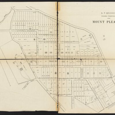
1874 Map of Mount Pleasant and Columbia Heights, DC

An 1874 Faehtz & Pratt map of Mt. Pleasant and Columbia Heights, from before the streets were renamed, when Newton St. was Howard and Monroe was Sheridan.

Posted 1 min read

This is a great old map, about a decade earlier than this one of Columbia Heights and Mt. Pleasant. Click on it for a larger version to see more details. In this, Howard is Newton St. and Sheridan is Monroe, before the streets were renamed in the early 20th century.

The Real Estate Directory of the City of Washington, D.C., Suburbs of Washington City, Serial Number 50 is a series of maps of recorded subdivisions beyond the city limits published by Faehtz & Pratt in 1874. Maps show streets, lot numbers and dimensions, property lines, and some building footprints. Landowners and estate names are included for large parcels. Outside of Georgetown, subdivision maps showing only property lines indicate that they were undeveloped at that time.
The Real Estate Directory of the City of Washington, D.C., Suburbs of Washington City, Serial Number 50 is a series of maps of recorded subdivisions beyond the city limits published by Faehtz & Pratt in 1874. Maps show streets, lot numbers and dimensions, property lines, and some building footprints. Landowners and estate names are included for large parcels. Outside of Georgetown, subdivision maps showing only property lines indicate that they were undeveloped at that time. (Dig DC)
The Email

Liked this one? Get more tomorrow.

Lost Washington stories in your inbox most mornings: the newest, plus a few from the archive.

Stories like these, most mornings
  • This story1874 Map of Mount Pleasant and Columbia Heights, DC
  • The Murder of Lola Jane Henry
  • Houdini’s Straitjacket Escape Above 15th and G Streets, 1922

Free. Unsubscribe anytime.

We use AI to help research, write and edit stories across our sites. Here’s how we use AI.Suggest a correction

The Kenesaw a view from the northeast (Flickr user: parkview dc)Read nextThe Kenesaw Building: The Suburbs of 1906 Washington, D.C.A 1906 Washington Times article praised the Kenesaw’s views and apartments while recalling opposition to its construction permit.Keep reading2 min read
On the Atlas

See the 2 places in this story.

Mount Pleasant · Columbia Heights

Open the map