
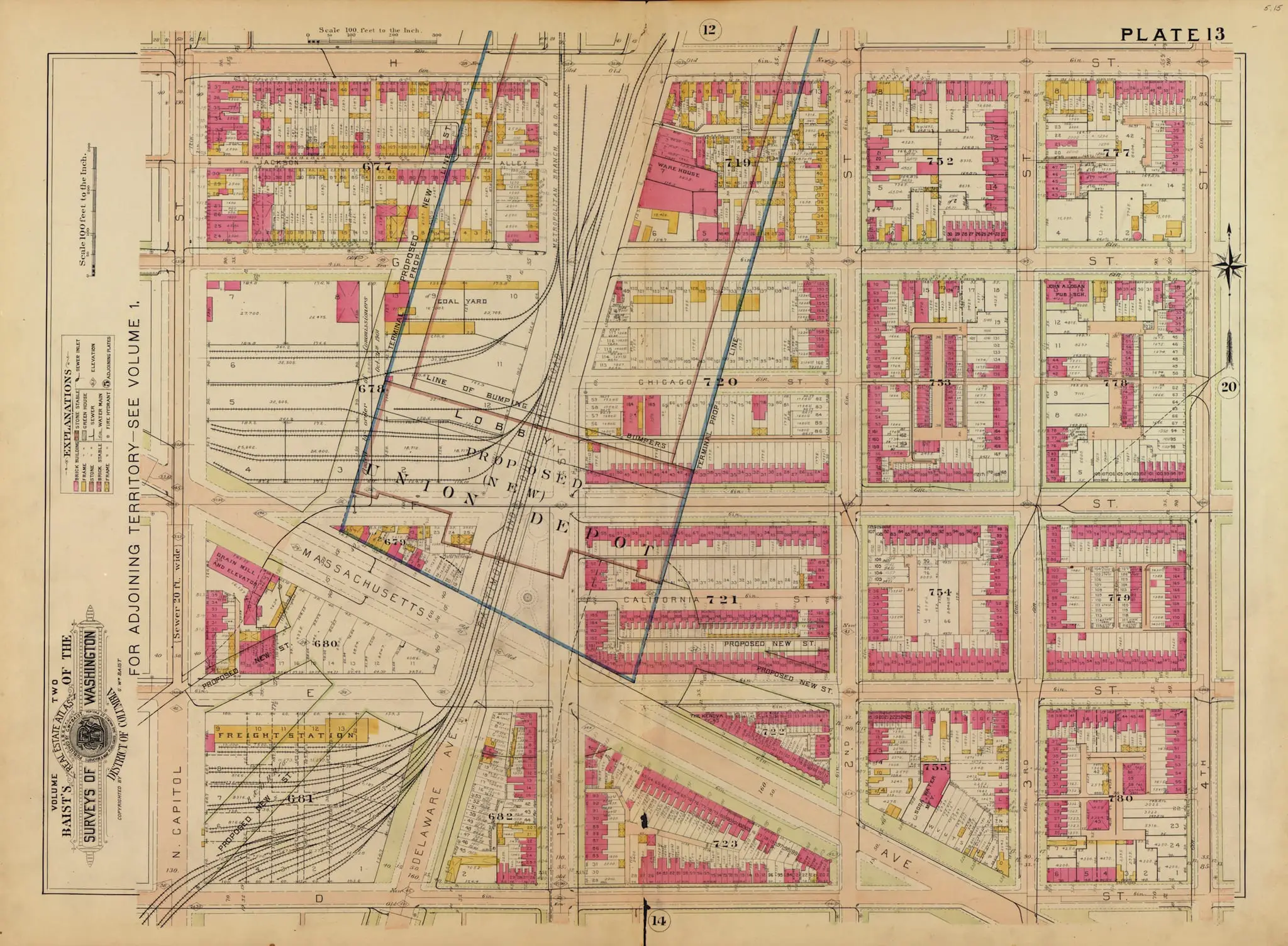
This is plate 13 of the 1903 Baist Real Estate Atlas of Washington. The existing street grid, the existing rowhouses, and the existing squares are all drawn in pink and yellow.
Superimposed in blue ink over the middle of it are the proposed rail approaches and station footprint of the not-yet-built Union Station. The block of text in the middle says PROPOSED UNION DEPOT. Every block and every house under that blue ink is about to be gone.
The neighborhood under the blue ink was called Swampoodle, and it was the reason the Irish vote in Washington mattered.
Why Swampoodle
The name came from a newspaper reporter in 1857.
Tiber Creek, the stream that drained the ridge from Florida Avenue down to the Potomac, ran through the low ground between what is now North Capitol and First Streets NE. It was boggy. It was prone to flooding. When the workmen broke ground for St. Aloysius Catholic Church at First and I Streets NE that summer, the reporter called the site a swamp full of puddles. Locals shortened it to Swampoodle.
By the 1860s the neighborhood had boundaries, if ill-defined ones: from K Street NE to G Street NE between 2nd Street NW and 2nd Street NE, with fingers of Irish settlement pushing east toward Florida Avenue along the creek. The residents were Catholic, mostly Irish, many of them refugees of the Great Famine who had come down from the northern cities to take federal and railroad construction jobs. They had goats and cows in their back alleys. They had saloons on the corners. They had a baseball ground at North Capitol and F Streets where the Washington Nationals played in the 1880s. They had two institutions that gave them a backbone.
St. Aloysius Catholic Church opened its doors in 1859 on North Capitol and I Streets, a tall brick basilica with Roman pretensions and a painted altarpiece by Constantino Brumidi. Gonzaga College High School, founded 1821, relocated to the same square in 1871. Both are still there. An 1861 panorama from the Capitol roof looking north shows the Swampoodle rooftops spreading out below the dome.
What the City Did to Tiber Creek
Tiber Creek is the subplot of every story about this part of Washington.
In the 1870s, under the sweeping public-works program of Alexander “Boss” Shepherd, the District buried the creek in a brick sewer along the line of North Capitol Street. From Florida Avenue to M Street, the sewer was twenty feet in diameter. Below M Street it widened to thirty feet. A stream that had defined the low ground and the neighborhood for a hundred years was now a tunnel.
The flooding continued. So did the Irish. But the creek had become an engineering problem. And an engineering problem was something Washington was about to solve at scale.
The McMillan Commission Picks a Site
The Senate Park Commission, organized in 1901 under Senator James McMillan of Michigan, pulled together the biggest names in American city-making. Daniel Burnham, fresh off the Chicago World’s Fair. Frederick Law Olmsted, Jr. Charles McKim. Augustus Saint-Gaudens. Their job was to rewrite L’Enfant’s plan for the monumental core of Washington, and their report, delivered to Congress in January 1902, included two decisions that together would kill Swampoodle.
First, the two existing train stations had to go. The B&O’s station on New Jersey and C Streets NW and the Pennsylvania Railroad’s station on the Mall itself were disfiguring the view from the Capitol to the future Lincoln Memorial. They had to be consolidated and moved.
Second, the new station would go north of the Capitol, on the site currently occupied by Swampoodle.
The Union Station Act of 1903 authorized it. Daniel Burnham got the design commission. The Pennsylvania Railroad and the Baltimore and Ohio agreed to share. The 1903 Baist plate above was drawn the same year, with the blue ink laid over the doomed blocks as a public notice.
Ten Blocks, One Hundred Houses, Sixteen Hundred People
When construction began in 1907, squares 714 through 720 came down. Over one hundred houses were demolished. Approximately sixteen hundred residents were displaced. Delaware Avenue, the main north-south street of Swampoodle, was buried under the rail yards between Florida Avenue and Massachusetts Avenue, leaving only a stub between L and M Streets NE. The buried section is still gone today.
Tiber Creek’s sewer stayed where it was. The tracks ran over the top.
The station opened in 1908. Here it is a year or two later, the plaza in front still empty of its Columbus Fountain, which would be dedicated in 1912.
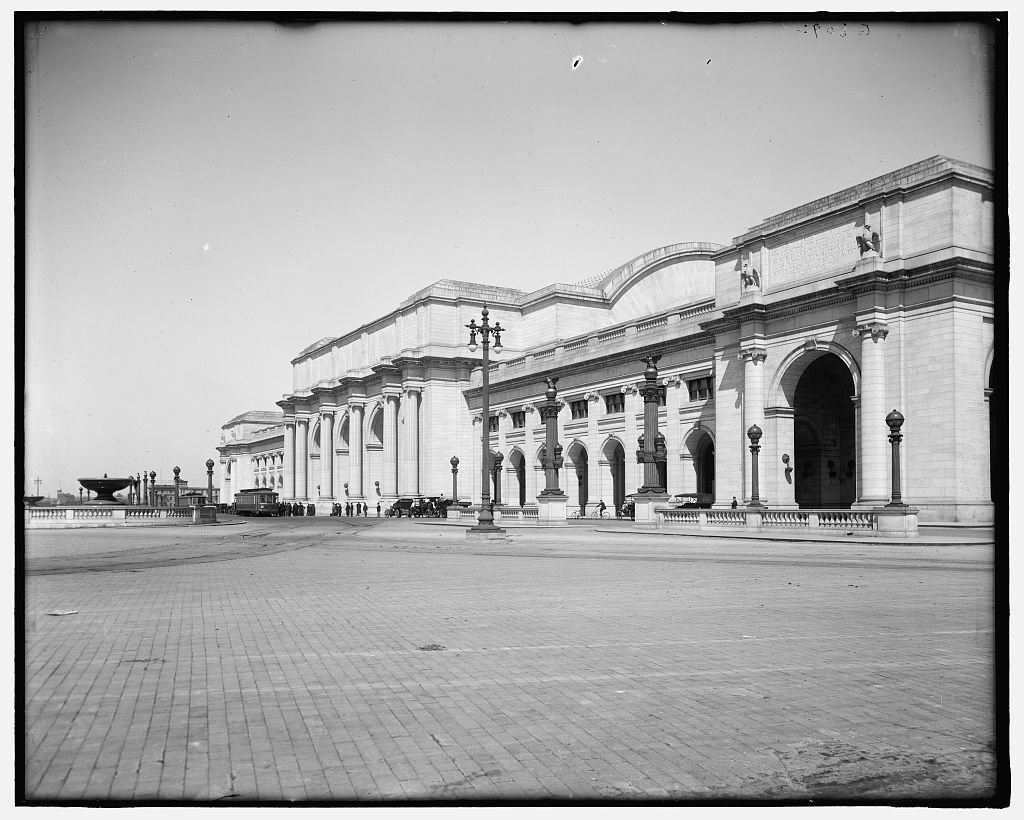
The marble and granite of Burnham’s facade. The bronze lampposts. The empty plaza where a neighborhood had stood six years earlier.
What’s Left
Swampoodle’s Irish had mostly scattered by the time Union Station opened, and not all of them had been displaced by the station. Many had already moved north to the new streetcar suburbs of Brookland and Brightwood. By the 1920s the surviving blocks around St. Aloysius were being resettled by Greek and Italian immigrants and by Black families pushed north out of Southwest. The name Swampoodle fell out of use.
St. Aloysius is still at 19 I Street NE. The Brumidi altarpiece is still inside. Gonzaga still teaches high school boys on the same square where it landed in 1871. The Government Publishing Office sits across North Capitol Street on land that used to be rowhouses. A few blocks of 19th-century brick rowhouses survived on the east side of the tracks and have been rebranded since 2007 as NoMa, shorthand for “north of Massachusetts Avenue.” Union Station itself looks very much like it did in 1963, or 1953, or 1908.
The word Swampoodle does not appear on any city sign. The buried creek does not appear on any map.
The blue ink on the 1903 Baist plate worked. The neighborhood it covered is gone.
Was this considered a disregard for the Irish Community at the time?
I hate to be a nudge but its hard to compare the two when they only overlap by one block.
FWIW, the plat map depicted above is available for free on Library of Congress’ website. they have a ton of maps, many as a very large high resolution scans, including three editions of Baist’s plat atlases that are great indicators of a changing DC landscape.