
Are you familiar with the District’s boundary stones? Yes, those stones, which happen to be the namesake of one of my favorite bars in Bloomingdale.
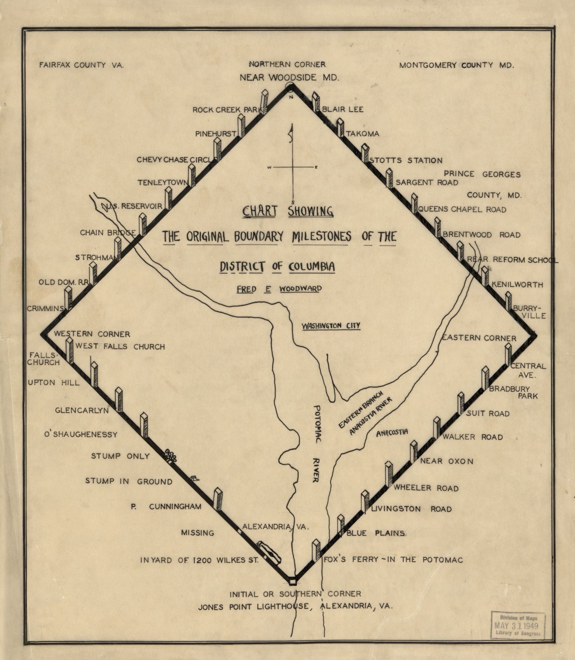
Here is a cool map that we dug up showing the location of all the boundary markers of the original District of Columbia. The original stones marking the boundaries of our new federal city were set up by Andrew Ellicott 1790.
According to the Library of Congress, this map is dated 1906 and was done by Fred Woodward.
Source: Library of Congress
By the way, isn’t it nuts that 60 years ago, people working in the archives or Library of Congress would just stamp the original maps with the date it was catalogued.
It’s interesting to see how big the original boundries of DC were so far into Virginia (and probably Maryland).
The boundaries haven’t changed. The Virginia portion, of course, was ceded back and is now Arlington County and Alexandria City.
For lots of cool information about the boundary stones, including photos, go to http://www.boundarystones.org/
You beat me to this. It is a great resources with articles and other cool things. The article “The Boundary Monuments of the District of Columbia” was my personal favorite because it has a lot of images of the stones from the turn of the century I think.
Have you ever visit any of the boundaries? My goal is to visit all one day.
I’d really love to. Have you or Mike?
There’s one on Southern Avenue. It’s in a fence and was right in front of an apartment building my cousin lived in, and down the street to where I lived on PA Ave years ago. It was never encased in the fence before they built the Apartments back in the 1960’s and people didn’t even know what it was. Then one day they put a fence around it.
Check out the Boundary Stones Bike Ride hosted by Boundary Stone Public House! The 3rd annual will be this September. You can start training for the 60 mile ride now. 🙂
I visit all 40 site in a day on the first Sunday in May and have done so for the last 10 years. Amazing and Educational. I could go on and on about the history of the survey, the history of the preservation effort, and the current status of each of the stones and what has transpired with them since 2005.
I discovered the stones back in the seventies while doing land surveys in Arlington. It was cool both visiting them and actually using and referencing them in my surveys.
I’ve been to a few. One on Western Avenue (“Tenleytown” in the map above) is actually on the Maryland side of Western Avenue a block from River Road, near Fessenden St., in a little cage to protect it from vandalism.