Skip to content
Ghosts of DC

Ghosts of DC

  • The Best Of
  • Neighborhoods
    • Southwest DC
      • Waterfront
    • Maryland
      • Gaithersburg
      • Rockville
      • Bethesda
      • Hyattsville
      • Silver Spring
      • Bladensburg
    • Virginia
      • McLean
      • Falls Church
      • Alexandria
      • Vienna
      • Arlington
    • Southeast DC
      • Congress Heights
      • Navy Yard
      • Capitol Hill
      • Anacostia
    • Northeast DC
      • Trinidad
      • Woodridge
      • Deanwood
      • Brookland
    • Northwest DC
      • Tenleytown
      • Park View
      • Friendship Heights
      • Brightwood
      • Crestwood
      • Sheridan-Kalorama
      • The Palisades
      • Logan Circle
      • Petworth
      • Glover Park
      • Bloomingdale
      • Georgetown
      • Woodley Park
      • Dupont Circle
      • Columbia Heights
      • Cleveland Park
      • Adams Morgan
      • Mt. Pleasant
      • Chevy Chase
      • Cathedral Heights
      • Chinatown
    • Lost Neighborhoods
      • Hell’s Bottom
      • Swampoodle
      • Murder Bay
  • Notable People & Places
    • Places
      • Washington Monument
      • Library of Congress
      • The White House
      • The Capitol Building
      • Dulles Airport
    • People
      • Franklin D. Roosevelt
      • Calvin Coolidge
      • Officer Sprinkle
      • Dwight D. Eisenhower
      • Warren G. Harding
      • William McKinley
      • Abraham Lincoln
      • John F. Kennedy
      • Teddy Roosevelt
      • Woodrow Wilson

1900s

The 1900s opened with the Senate Park Commission’s plan to redesign the National Mall, launching one of the most ambitious urban transformations in American history. Theodore Roosevelt’s presidency brought energy and ambition to the capital, and the city’s grand Beaux-Arts institutions began rising across downtown. These posts cover Washington at the dawn of the American century.

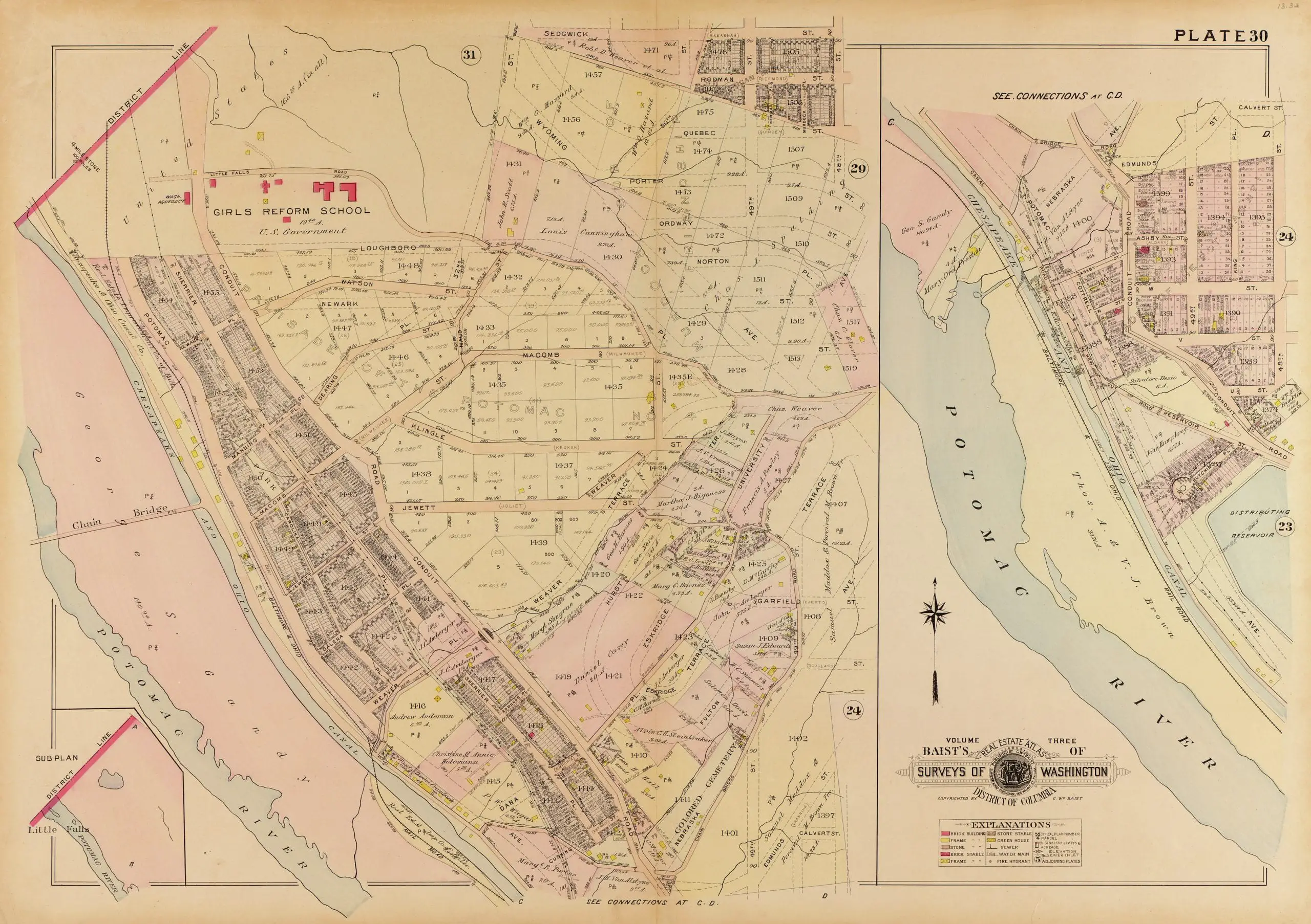
A History of Tennallytown: From 1903 Map to Google Map

November 9, 2022May 25, 2017 by ghostsofdc

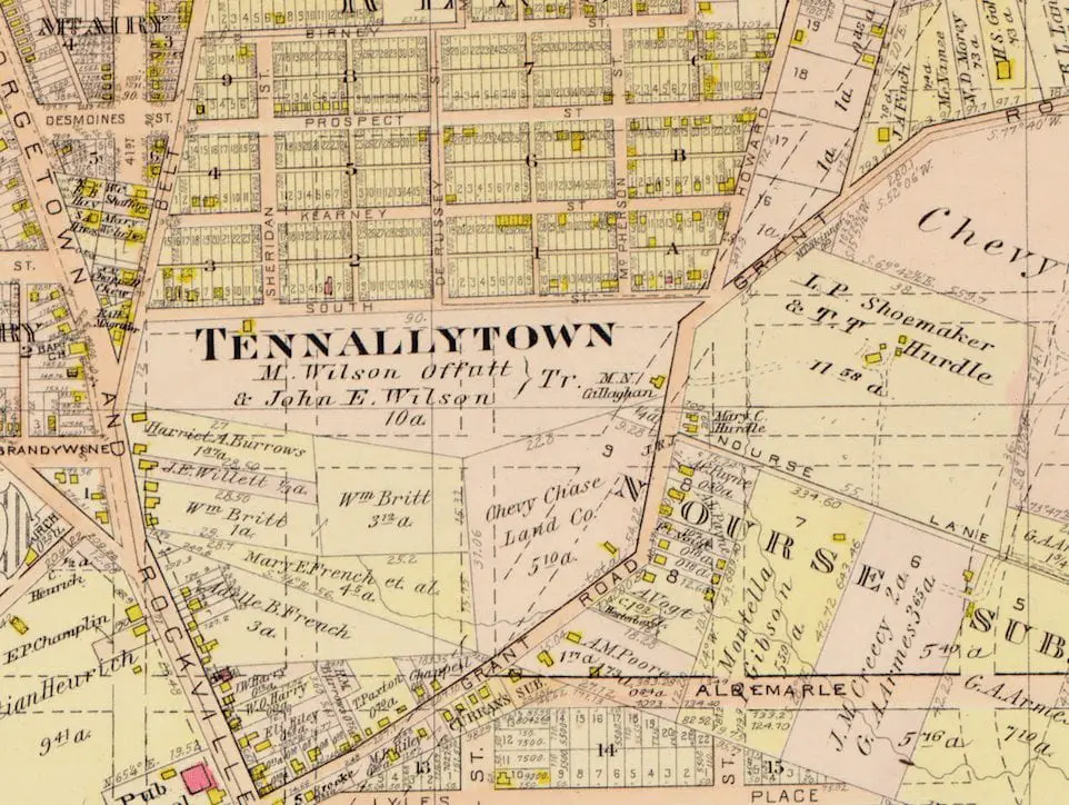
Take a journey through time with this fascinating post about the history of Tennallytown. From a 1903 map to a modern-day Google Map, you won’t want to miss this fascinating post.

Categories GoDCers Love Maps Tags 1900s, Tenleytown 1 Comment

Exploring the Past and Present of Washington, DC with Maps

November 9, 2022May 24, 2017 by ghostsofdc

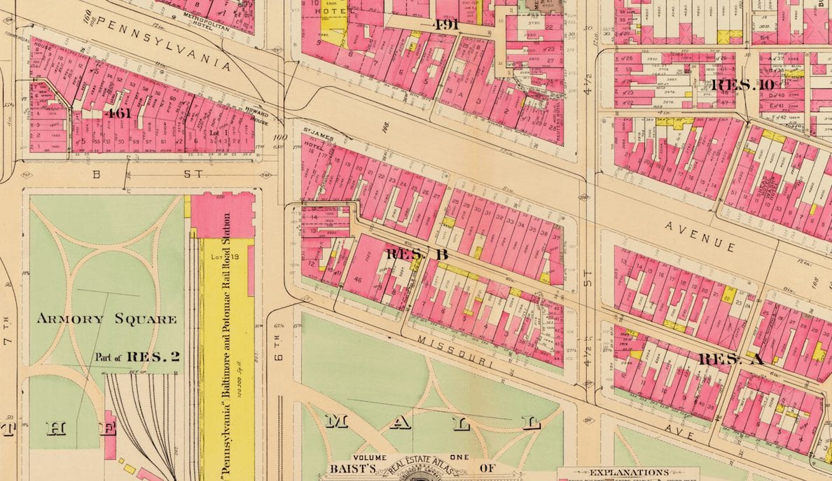
Digging into the past of Washington, DC? Check out this comparison of an old 1903 Baist map of DC near the Capitol and a Google Map of the same area in 2017. See how much things have changed!

Categories GoDCers Love Maps Tags 1900s, National Mall

15th and F Streets NW in the Early 1900s: Horse Carriages and a Bicyclist

April 27, 2026June 30, 2016 by ghostsofdc
View of 15th & F Streets, NW looking east with horse carriages and a bicyclist pictured.

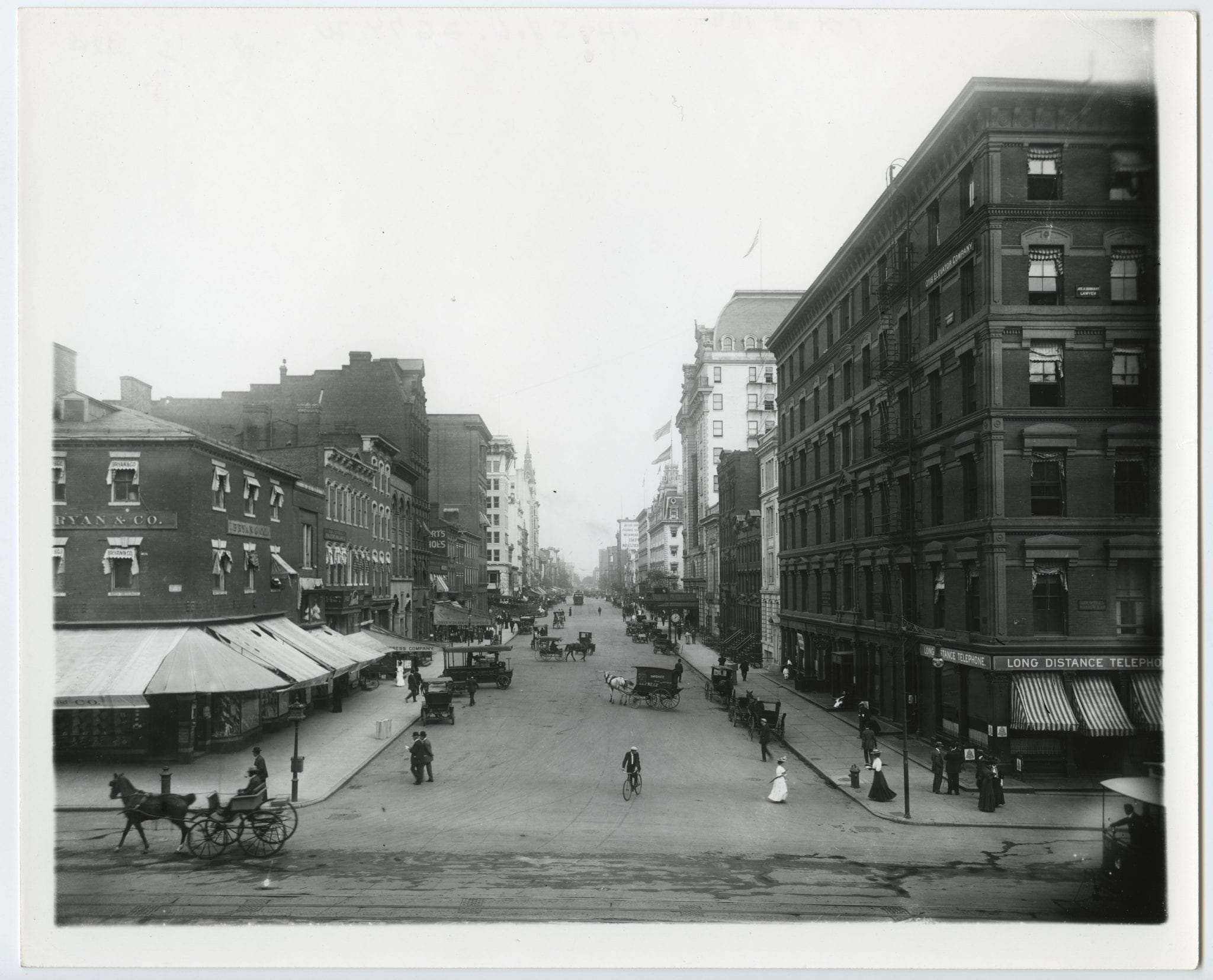
A photograph of 15th and F Streets NW in the early 1900s, showing horse carriages and a bicyclist sharing the street.

Categories Faces & Places of Yesterday Tags 1900s, Architecture

A Look at Historic Homes in Washington Heights from 1904 and Today

November 9, 2022May 5, 2016 by ghostsofdc
Evening star., May 07, 1904

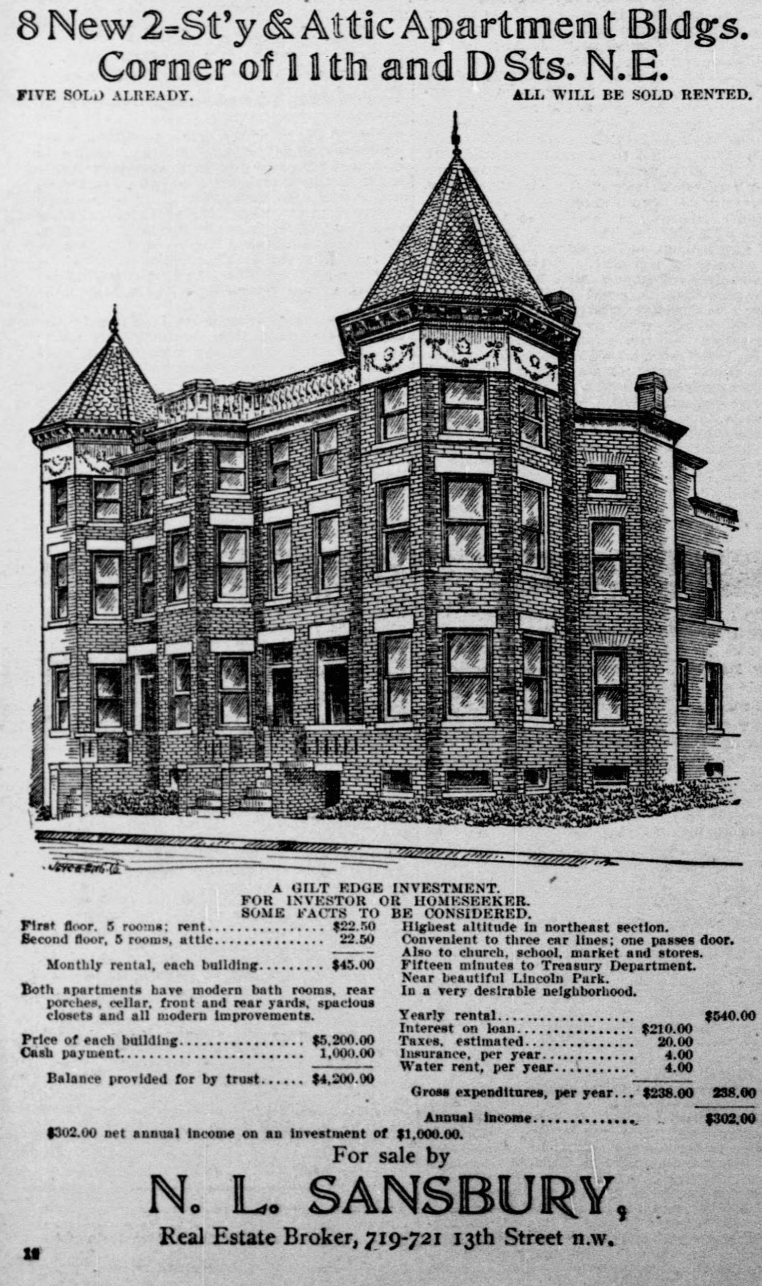
Take a look back in time with this cool old advertisement from 1904 for homes in Washington Heights. Compare it to what the same homes look like today using Google Street View!

Categories Old Ads & Classifieds Tags 1900s, Capitol Hill 1 Comment

Take a Look at what the Jefferson Memorial Area Looked Like Before 1943

November 9, 2022September 2, 2015 by ghostsofdc
The view south from the top of the Washington Monument. Ice covers half of the Tidal Basin

Take a look at this great photo from 1908 showing what the area around the Jefferson Memorial and the Capitol Building looked like before the memorial was completed in 1943.

Categories Notable People & Places Tags 1900s, Jefferson Memorial

Unearthing a 1909 Map of the Palisades During a Birthday Celebration

November 9, 2022September 1, 2015 by ghostsofdc
1909 map of the Palisades

Mrs. Ghost, Ghost Baby and I spent a nice Saturday afternoon celebrating a birthday at a lovely home in the Palisades. We found an old 1909 map of the area. Check out the results and the source of the map in our blog post!

Categories GoDCers Love Maps Tags 1900s, The Palisades

Washington, D.C. in 1904: A Full Map of the City and Surrounding Area

November 9, 2022July 7, 2015 by ghostsofdc

This 1904 map from the Library of Congress covers Washington, D.C. and the surrounding region in detail. It shows the city a year before the Height of Buildings Act was passed and decades before the highway system reshaped the area. Click through to zoom in.

Categories GoDCers Love Maps Tags 1900s 11 Comments

Why Is It Named Clarendon?

April 23, 2026May 18, 2015 by ghostsofdc

Clarendon started as a rail-stop development along the Georgetown to Falls Church road, now Wilson Boulevard.

Categories Why Is It Named...? Tags 1900s, Arlington 6 Comments

Tragic Drowning of a Young Man on the Potomac River, 1908

November 9, 2022April 29, 2015 by ghostsofdc
Potomac River

This is a sad story of a young man, John McCalip, who was drowned in the Potomac River in 1908, shortly before his wedding. Read more about his story and the tragedy that happened on the river.

Categories From the Crazy Vault Tags 1900s, Potomac River 2 Comments
Older posts
Newer posts
← Previous Page1 … Page3 Page4 Page5 … Page23 Next →
Explore the Archive
The Best Of Old Ads & Classifieds Then and Now Lost History
GoDCers Love Maps From the Crazy Vault Faces & Places of Yesterday If Walls Could Talk
Historical Events Notable People & Places This Day in History Guest Posts
Three Things… A Personal Story Why Is It Named…? Featured
Ghosts of DC© 2012–2026 Ghosts of DC · AI Policy